At uz prijedete ke Dzbanu z
kterehokoliv smeru, s opukou se zcela jiste setkate. Tato
specificka hornina totiz formovala okolni krajinu hned dvakrat. Za
prve stoji za vznikem hlubokych udoli a plochych nahornich
planin jako je Rovina nad Kounovem, anebo planina, na kterou vas
privede tato kes. Za druhe se opuka v uplynulych staletich
stala oblibenym stavebnim materialem a domy postavene z
neomitnutych belavych kvadru jsou symbolem zdejsiho kraje. Je
zajimave, ze opuka je velmi mistni zalezitosti. Jen obtizne by se
vam podarilo najit ve svete horninu se stejnymi vlastnostmi. Svedci
o tom i to, ze pro opuku neexistuje jednoznacny termin v jinych
jazycich. V nemcine je tento typ horniny nazyvan Flammenmergel,
Schwammflitstein nebo Amberger Tripple, v anglictine pak
spongilite, calcitic spongilite nebo cretaceous spongilite,
nespravne pak i marl, marlstone nebo clay marl. Jak
komplikovane proti napr. vapenci (Kalkstein, limestone) nebo
piskovci (Sandstein, sandstone).
Opuka krajinotvorna
Opuka patri mezi horniny usazene.
Mezi hlavni slozky patri spongility (spongiliticke jilovce), ruzne
formy kremicitych usazenin, zpevneny jil a ruzne mnozstvi kalcitu
plniciho funkci pojiciho materialu. Opukove usazeniny
vznikaly v druhohorach zhruba pred 90 miliony let na dne
kridoveho more. Dokladem puvodu opuk jsou zkameneliny morske fauny
a tvori je predevsim lastury a ulity mekkysu. Typickou primesi
opuky jsou mikroskopicke jehlice morskych hub tvorene opalem (tzv.
spongie - odtud obcas pouzivany nazev spongilit). Opukova vrstva je
silna 3 - 12 metru. Sama o sobe je pomerne tvrda, lezi ale na
mekkem permskem piskovci. Tento piskovec snadno zvetrava a po
jeho odplaveni dochazi i k odlamovani svrchni opukove vrstvy. To
vysvetluje podobu zdejsiho kraje: Celistva opukova vrstva nahornich
planin je z okraju "ohlodavana" eroznimi vlivy. Jakmile jednou
vznikne v tabuli zarez, eroze nabira na rychlosti, udoli se
prohlubuji a rozsiruji. Jejich sklon zustava prudky, protoze jejich
horni cast je opevnena opukou a nepoddava se erozi tak rychle jako
mekci hornina pod ni.

Opuka mestotvorna
V Cechach je nekolik oblasti, kde
se opuka tezila - predevsim v okoli Prahy (Bila hora, Petrin, nyni
jediny cinny lom v Predni Kopanine), dale Dzbansko na Rakovnicku. V
severnich Cechach jsou zname lokality v okoli Loun (Zemechy) a
Zernosek. Nekolik mene vyznamnych lokalit se nachazelo i ve
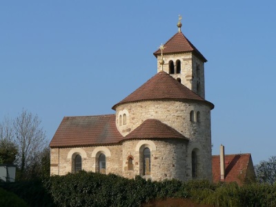
vychodnich Cechach. Opuka pro svoji lehkost a snadnou
opracovatelnost byla v minulosti zakladnim stavebnim materialem
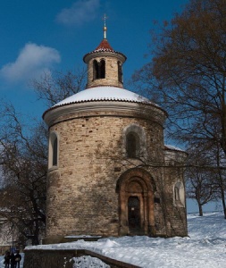
vsech okolnich stredovekych mest, vcetne Prahy. Jsou z ni postaveny
vsechny romanske rotundy, bazilika sv. Jiri na Prazskem hrade,
klaster sv. Anezky ceske a mnohe dalsi vyznamne stavby. Opuka byla
pouzivana rovnez jako socharsky material - pripomenme znamou
keltskou hlavu z Mseckych Zehrovic nebo sarkofagy Premyslovcu v
chramu sv. Vita. Krasny a historicky cenny je napriklad detsky
opukovy nahrobek Premyslovny Guty II. (+ 1207), dcery Vaclava II.,
nalezeny v klastere sv. Anezky ceske na Starem meste. Z opuky je
rovnez postavena rada vesnickych domu a kostelu v mistech jejiho
vyskytu, tedy i ve vesnicich kolem Dzbanu. Mnohe z nich jste jiste
zahledli cestou sem.

Kostel sv. Mari Magdaleny,
Predmi Kopanina
foto Martin Vavrik, Wikimedia Commons |

Rotunda sv. Martina,
Vysehrad
foto Adam Zivner, Wikimedia Commons |
O kesi
Nejpohodlnejsi pristup je od
silnice spojujici Hredle a Treboc. Tam muzete zanechat sve auto
(viz parkovaci waypoint). Od silnice jdete za sipkou po
zlute znacene turisticke trase. Vsimnete si, ze jdete tesne po
hrane nahorni plosiny. Na mnoha mistech staci jen par kroku vlevo
do lesa a stojite nad eroznim srazem. Obcas se vam podari
zahlednout udoli pod vami. Od jara do podzimu vsak vyhled byva
zakryty korunami stromu, proto doporucuji navstivit vyhlidkove
misto uvedene ve waypointech. Je to jen kousek od cilovych
souradnic. Ty vas privedou na okraj jednoho z poslednich
fungujicich opukovych lomu v Cechach. Vstup do lomu je zakazan
navzdory tomu, ze prekazky vstupu jsou spise symbolicke. Lomovou
stenu si muzete dobre prohlednout i z cesty.
 |
Podminky pro zalogovani nalezu:
- Na emailovou adresu uvedenou v profilu mi prosim poslete
odpovedi na nasledujici otazky:
a) Jak opuka vznikla?
b) Od ceho je podle vaseho nazoru odvozen nazev "opuka"?
c) Shybnete se a vezmete do ruky jeden z mnoha opukovych ulomku.
Dobre si jej prohlednete a ohmatejte. Popiste vysledky vaseho
zkoumani.
d) Jaka je podle vas pricina toho, ze z opuky postavene domy
zustavaji casto neomitnute?
- Nepovinne: Ke svemu logu pripojte prosim vasi fotografii na
vyse uvedenych souradnicich s lomem v pozadi.
|
 |
Whatever
direction you come from, you will surely see "opuka". This unusual
rock has formed the country around Dzban twice: First, its
presence led to the formation of deep valleys and flat table
mountains - like the one where this earthcache is located. Second,
opuka was the most popular construction material in past, and
buildings from white stones are very typical for the villages in
the surrounding area. Opuka is a very local, specific rock. It
would be very difficult to find an identical mineral elsewhere in
the world. You can see it even on its name in other languages: In
German it is called Flammenmergel, Schwammflitstein or
Amberger Tripple. In English similar rocks are called spongilite,
calcitic spongilite or cretaceous spongilite, incorrectly
also marl, marlstone or clay marl. How complex compare
to e.g. limestone (Kalkstein) or sandstone (Sandstein).
Opuka shaping the country: Opuka
belongs to sediments. Its main components are spongilits, various
forms of silicate sediments, hardened clay and variable amounts of
calcite that plays the role of a glue. Opuka sediments were
formed in mesozoic era about 90 million years ago, on the bottom of
cetraceous sea. The proof of opukas origin are fossils of sea
fauna, especially molluscoids' shells. A typical component are also
microscopic needles of sea sponges containing opal. Opuka layer is
about 3 - 12 meters thick. It is relatively hard, but it is just
above soft permian sandstone. This sandstone is easily eroded and
as it is being washed away, the harder opuka layer above it starts
breaking and falling down too. This explains the presence of table
mountains and deep cuts of valleys in them: Once the erosion finds
its way into the opuka layer, it keeps progressing, the valleys
grow deeper and wider while the slope continues to be very steep -
because the top layer is "fortified" by opuka and resists better
the erosion.
Opuka shaping the towns: There are
sevaral areas in Czech R. where opuka has been mined - especially
around Prague, in Dzban area (i.e. here), or in Northern and
Eastern Bohemia. Opuka as a light and easy to shape rock was a
key construction material of Czech medieval cities, incl. Prague.
All Romanesque rotundas are built from opuka, as well as the
basilica of st. George at Prague castle, or the monastery of st.
Anezka the Czech. Opuka was also frequently used by sculptors -
let's mention the Celtic head that was found in Msecke Zehrovice
not far from here, or coffins of Premyslid kings in Prague
Castles's st. Vitus cathedral. Opuka was also used for less noble
but equally nice village houses and churches in the villages around
Dzban. You must have seen many of them on the way here.
About the cache: The easiest access is
from the road connecting Hredle and Treboc. You can leave your car
there (see parking waypoint). From the parking follow the path
marked by yellow tourist signs. Please note you will be closely
following the edge of the plateau. Very often it would take
just a few steps among the trees on your left hand side and you
would find yourself on top of a very steep slope. From time to time
you will get a chance to see the valey down below you. For most of
the year the view is obstructed by trees, so if you really want to
enjoy it please visit the viewpoint (see the waypoints). It is not
far from the final coordinates. Those will bring you near one of
the three last active opuka quarrys in Czech Republic. The entry is
prohibited, but you can easily see the opuka wall from the
road.
To
log the find:
- Please send me answers to the following questions via my
profile:
a) What is the origin of opuka?
b) The word "opuka" can be translated as "cracking stone". What do
you think is the origin of the Czech name?
c) Please find one opuka stone, touch it, feel it. Please
describe your findings.
d) In your opinion, why do the opuka buildings have the stones
exposed, i.e. without any plaster?
- Optional: Please attach a photo of yourself in front of
opuka quarry.
|
