Table mountain Vidoule
CZE
Vyrazna tabulova hora tvorena
reliktem horizontalne ulozenych kridovych vrstev s vychozy na
okrajove hrane. Refugium drobnych zivocichu a vyznamny krajinny
prvek.
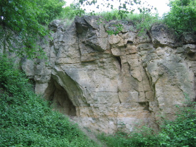
Ukazka tabulove hory, geologicke profily perucko - korycanskym
souvrstvim cenomanu s cetnymi skalnimi vychozy piskovcu prekrytymi
vrstvou slinu az slinovcu (opuk) spodniho turonu, ktere tvori
vrcholovou plosinu (jiz mimo CHU). Ze zkamenelin muzeme uvest druhy
Inoceramus labiatus, Enoploclythia leachi a Rhynchostreon
suborbiculatum. V podlozi kridy zvrasnene bridlice a piskovce
ordovickeho stupne beroun. Vetsinou oligobazicke hnede pudy, misty
obohacene splachy slinovcu, casto narusene nekdejsi tezbou.
Pramenny horizont.
Prevazuje druhotna chuda, casto poloruderalni vegetace. Steny
geologickeho profilu vetsinou zarostle vysadbou akatu a naletem
bezu cerneho, osiky a jivy, pouze jizni svah hosti na byvalych
mezich a pastvinach teplomilny travnik s valeckou praporitou a
kostravou zlabkatou. Z brouku stepniho charakteru zde byly zjisteny
i vyznamne druhy, napr. strevlicci Ophonus schaubergerianus,
Cymindis angularis, z fytofagu mandelinkoviti, napr. Coptocephala
rubicunda, Cryptocephalus violaceus, drepcik Aphtona cyanella a
stitonos Cassida rufovirens; z celedi Urodontidae Urodon conformis,
z nosatcovitych napr. bezkridle druhy Otiorhynchus fullo, O.
velutinus, tri druhy z rodu Trachyphloeus. Na jiznim otevrenem
svahu mekkysi s ohrozenou trojzubkou stepni (Chondrula tridens).
Bohaty kerovy porost je hnizdistem ptactva, napr. strnada obecneho,
penice cernohlave, drozda zpevneho, dnes jiz jen ojedinele tuhyka
obecneho, penice hnedokridle. Slavik obecny a dalsi druhy se
pravidelne zastavuji na tahu.
Severni usek je dnes umele zalesnen, prevazne nepuvodni borovici
lesni, porosty prirozenejsiho slozeni jsou az pod horizontalni
cestou, na vychodni strane lem starsich dubu, na jizni svahu
teplomilna vegetace. Zbytek je bezlesy nebo zarustajici
krovinami.
Lesni porosty jsou obhospodarovany v souladu s ochrannym rezimem. V
minulosti cely okraj plosiny Vidoule lemovaly piskovcove lomy,
takze piskovce zde, zejmena na severni strane, vystupuji v podobe
skalnich sten.
V soucasne dobe je CHU zahrnuto do prirodniho parku Kosire - Motol,
jehoz souvisly lesni komplex na severnim svahu primo navazuje na
zalesnenou hranu a zahrnuje i porosty v parku historicke usedlosti
Cibulka.
Pro uznani logu musite splnit:
Do logu vlozte fotografii (dle
spoileru) ze souradnic earthcache, na ktere jste Vy a piskovcova
skala za Vasimi zady.
Odpovezte na par otazek emailem
pres profil:
Jaky je vyskovy rozdil mezi vrcholem hory Vidoule a souradnicemi
earthcache?
Jaky typ kamene tvori vychodni cast tabulove hory Vidoule?
Na souradnicich N50° 03.415 E014° 21.488 se nachazi informacni
tabule pro zjisteni potrebnych informaci.
ENG
Eastern and partly also the northern
and southern edges of the Vidoule plateau above Jinonice and
Cibulka.
Distinct table mountain consisting in a relic of horizontal
Cretaceous strata with outcrops on the edge. Refuge of minor
animals and significant landscape element.
Example of a table mountain, geological profiles of the
Peruc-Korycany formation of the Cenomanian with numerous sandstone
outcrops, covered with a layer of marles to marlites of the Lower
Turonian, forming a plateau (outside the protected area). The
number of fossils includes Inoceramus labiatus, Enoploclythia
leachi and Rhynchostreon suborbiculatum. Below the Cretaceous
strata there are folded shales and sandstones of the Beroun step of
the Ordovician. Mostly oligobasic brown soils, locally enriched
with marlite outwash, often disturbed by past quarrying.
Aquifer.
Prevailing secondary poor, often semiruderal vegetation. The walls
of the geological profile are mostly overgrown with planted false
acacia and wind-swept elder, aspen and willow. Only the southern
slope hosts thermophilous grass with Brachypodium pinnatum and
Festuca rupicola on former balks and pastures.
From the number of beetles of steppe character even some
significant species have been ascertained, including Ophonus
schaubergerianus and Cymindis angularis from the ground beetles.
The phytophagous beetles include e.g. Coptodephala rubicunda and
Cryptocephalus violaceus from the leaf beetles, Aphtona cyanella
from the flea beetles, Cassida rufovirens, Urodon conformis, the
wingless Otiorhynchus fullo and O. velutinus from the snout
beetles, three species of the Trachyphloeus family, and others. The
southern open slope hosts the molluscs including the endangered
Chondrula tridens. The rich bushes are the nesting site of such
birds as the yellowhammer, the blackcap, the mistle thrush, today
only solitary red-backed shrike, and the common warbler. The
nightingale and other species stop regularly in passing.
The northern part has been forested artificially, mostly with
non-indigenous scots pine. Vegetation of a more natural structure
can be found below the horizontal road. On the eastern side there
is a border of older oaks, the southern slope is covered with
thermophilous vegetation. The remainder is free of woods or
overgrowing with shrubs.
The woods are exploited in accordance with the protection regime.
In the past the whole edge of the Vidoule plateau was bordered with
sandstone quarries, as a result of which the sandstones appear as
rock walls, particularly on the northern side.
At present the protected area is incorporated into the Kosire -
Motol natural park the forest complex of which on the northern
slope merges with the forested plateau edge and includes also the
vegetation in the park of the historical farmstead of Cibulka.
To log this cache you have to
Upload in the log photo (as spoiler)
from the earthcache coordinates with you and Vidoule sandstone rock
behind you.
Answer few questions with
email:
What is the difference in the altitude between the mountain Vidoule
and the earthcache coordinates?
What type of stone forms the eastern part of the table mountains
Vidoule?
With coordinates N50° 03.415 E014° 21.488 is information boards
will provide information.