Der Wasserfall befindet sich am Ende des Tals und mit seiner Höhe von 70 Metern ist der höchste Wasserfall in den Steirischen Alpen. Der Wasserfall wird durch den Bach Riesachbach gebildet. Der Bach fließt durch ein wildes Tal, in dem wird viele Kaskaden von dem See Riesachsee gebildet. Der See selbst hat ein glazial Herkunft. Rund um den Wasserfall ist ein Weg, die viele Brücken hat.

The waterfall is located at the end of the valley Untertal, leads him trail Alpinsteig Wilde Wasserand and with the height of 70 meters is the highest waterfall in of Schladming Tauers. The waterfall is formed by a brook Riesachbach, which flows the wild valley on which is creativy many cascades from lake Rieachsee.
Dept. Geography and Geology, University of Salzburg - geology neighborhood of Schladming - STUDY
Waterfall: A waterfall is usually a geological formation resulting from water, often in the form of a stream, flowing over an erosion-resistant rock formation that forms a sudden break in elevation or nickpoint. Some waterfalls form in mountain environments where the erosive water force is high and stream courses may be subject to sudden and catastrophic change. In such cases, the waterfall may not be the end product of many years of water action over a region, but rather the result of relatively sudden geological processes such as landslides, faults or volcanic action.
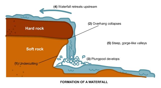
Formation: Typically, a river flows over a large step in the rocks which may have been formed by a fault line. Over a period of years, the edges of this shelf will gradually break away and the waterfall will steadily retreat upstream, creating a gorge of recession. Often, the rock stratum just below the more resistant shelf will be of a softer type, meaning undercutting, due to splashback, will occur here to form a shallow cave-like formation known as a rock shelter or plunge pool under and behind the waterfall. Eventually, the outcropping, more resistant cap rock will collapse under pressure to add blocks of rock to the base of the waterfall. These blocks of rock are then broken down into smaller boulders by attrition as they collide with each other, and they also erode the base of the waterfall by abrasion, creating a deep plunge pool or gorge. Streams become wider and more shallow just above waterfalls due to flowing over the rock shelf, and there is usually a deep pool just below the waterfall because of the kinetic energy of the water hitting the bottom.
 |
Types of waterfalls :
- Block: Water descends from a relatively wide stream or river.
- Cascade: Water descends a series of rock steps.
- Cataract: A large waterfall.
- Fan: Water spreads horizontally as it descends while remaining in contact with bedrock.
- Horsetail: Descending water maintains some contact with bedrock.
- Plunge: Water descends vertically, losing contact with the bedrock surface.
- Punchbowl: Water descends in a constricted form, then spreads out in a wider pool.
- Segmented: Distinctly separate flows of water form as it descends.
- Tiered:Water drops in a series of distinct steps or falls.
- Multi-step: A series of waterfalls one after another of roughly the same size each with its own sunken plunge pool.
To get log permission you must answer the following question and task :
- Take a foto (optionaly) you with GPS and the waterfall in the background on coordinates - spoiler
- What is altitude at the position ?
- What type of waterfall that is ?
All answers send to my email krutizlab.geo@gmail.com
Short clip from Riesachwasserfall