The published co-ordinates will take you to the general vicinity of the carpark. All questions and tasks can be completed from within a short walking distance of here.
History
The Glass House Mountains were named by Lieutenant James Cook in 1770. It is believed that Cook thought the peaks resembled the glass furnaces in his hometown of Yorkshire, England.
For generations the Glass House Mountains have held great significance for the Aboriginal people. Their creation stories and beliefs are reflected in the strong links that remain today. Because these mountains are of high spiritual significance to the local indigenous people, you are asked to be considerate and use only the existing walking tracks and lookouts provided.
The fire lookout has been here since the 1930’s. It has been modified to cater for visitors while still being used for fire spotting. Depending on weather conditions rangers and forest officers can keep a year round watch from fire towers like this in the area.
Geology
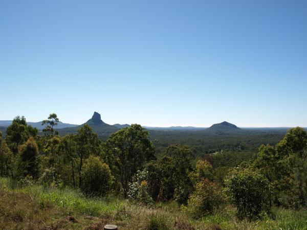
There are at least a dozen plugs, the remains of volcanoes that pushed their way up through thick almost-horizontal layers of sandstone. It is hard to imagine what it would have been like as the volcanoes were erupting, spewing red-hot ash and lava from their vents and darkening the atmosphere with ash and fumes.
The lava was rich in silica and formed rhyolite and trachyte, volcanic rock that is typically yellow, pink, pale grey and other light colours. Silica-rich lavas are thick like porridge and leave characteristic steep sided volcanic plugs.
Many of the plugs have well developed columnar jointing. The northern face of Mt Beerwah is one prominent example, and the exposed columns are dubbed ‘The Pipe Organ’. Such long columns suggest the lava was extruded rapidly, generating a large volume that solidified and cracked as one extrusion.
At around the same time, volcanic eruptions of a different kind were active to the north and west. In this case the lava was basaltic in composition, rich in iron and magnesium, and it was hotter and more fluid than the lava that formed the plugs. This red-hot molten rock ran like water across the sandstone plateaus and solidified to form thick basalt caps, the Mapleton plateau being one example. Basalt lava forms rich red and brown soils ideal for farming and for the development of rainforest.
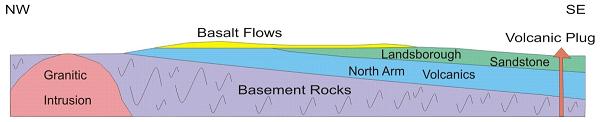
The countryside around the Glass House Mountains is made of sandstone, geologically called the Landsborough Sandstone. The thick strata are visible in road cuts along the highway. The Landsborough Sandstone is part of an interconnected series of sedimentary basins called the Great Australian Basin, which extends from the east coast of Australia for thousands of kilometres south and west into New South Wales, west into South Australia and the Northern Territory and north to Cape York in northern Queensland.
The thickness and geographical extent of the strata point to deposition from massive surges of flowing water. Dinosaur footprints are found in some sandstone horizons near Brisbane, and out west near Winton. In other parts of the basin the well preserved remains of plesiosaurs and dinosaurs have been discovered.
Just before the Glass House volcanoes erupted, the landscape had been cut flat, forming an extensive plateau. After the eruptions a hundred metres of sandstone or more was eroded from the countryside around the volcanic necks leaving the remains of the plugs intact. Much of the basalt plateau was also eroded away but a remnant is preserved to the north and west, and is now a popular tourist destination.
Once you complete the following EarthCache requirements you can post your find without delay, as per the EarthCache guidelines. You will also need to verify your find by sending us a message with your answers to these questions and we will answer in due course:
1. Use the text "Glass House Lava Plugs - GC2A5JF" in your message.
2. Standing at the published co-ords how many mountains can you see?
3. What is your elevation here?
4. What is the highest mountain?
5. After the eruptions how many metres of sandstone were eroded from the countryside around the volcanic necks ?
6. What is "columnar jointing" and how is it formed ?
7. (OPTIONAL) Take a photo of yourself and GPS with the mountains in the background and post with your log.
Please DO NOT post answers with your log.