River Trebižat
Geography and
hydrology
River Trebižat is located in the south-western region of
Bosnia and Herzegovina. It's a part of the Neretva basin and it is
the Neretva major tributary.
The Trebižat is 51 km long and it is second
largest "sinking river" that drains into the underground and
reappears at resurgences various times in Bosnia and Herzegovina,
next to the Trebišnjica
river which is largest river of that kind on the world and also
part of the Neretva watershed.
The water regime of the Trebižat river is affected by the
abstraction of its water for hydropower
plants, irrigation and fish farming. The Trebižat river
flows through an area of remarkable ecological value hosting a
protected area such as the travertine-formation around Kravica
waterfall.
Travertine is a form of limestone deposited by
mineral springs, especially hot
springs. Travertine often has a fibrous or concentric
appearance and exists in white, tan and cream-colored varieties. It
is formed by a process of rapid precipitation of calcium carbonate,
often at the mouth of a hot spring or in a limestone cave. In the
latter it can form stalactites,
stalagmites and other speleothems.
It is frequently used in Italy and elsewhere as a building
material.
Travertine is a terrestrial sedimentary rock, formed by the
precipitation of carbonate minerals from solution in ground and
surface waters, and/or geothermally heated hot-springs. Similar (but softer and
extremely porous) deposits formed from ambient-temperature water
are known as tufa.
Although there have been many negative impacts in recent years
on the Trebižat river, the analyses of aquatic organisms,
river ecology and river morphology
showed a high diversity. Various actions are considered with the
aim of preserving the Trebižat river and its riparian ecosystem.
The area was assessed in terms of its geography, climate
conditions, historic heritage of the river, demography, geology of
the river and its tributaries, river hydrology and morphology,
ecological characteristics,
river pollution, river use and
river management.
Nine names of the river
Trebižat
Thanks to the fact that the Trebižat river looses and
reappears at resurgences various times people used to call it with
different names. Exactly nine names are known, every time it
resurfaces or enters the next area on its path the river got a new
name.
Kravica
waterfalls
A special characteristic of Bosnia and Herzegovina's water
systems are the plethora of waterfalls dotting the landscape. Among
the most beautiful and biggest are the: Štrbacki cascade
(23,5 m high – quantitively the biggest waterfall in BiH),
Martin Brod on the Una river, the Pliva waterfalls in Jajce (27 m)
and Kravica waterfall on the Trebižat River.
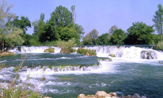
The most attractive landmark on the Trebižat River is the
Kravica waterfall, located
3 km downstream from the Vitaljina, in Studenci near
Ljubuški. Here the river drops into a horseshoe-shaped
canyon with a lake below the falls of 120 m in radius. The calcium
scale layer from the bottom to the top of the falls is
covered by grass and
moss. The same as the Krka
Waterfalls and Plitvice
Lakes, the Trebižat river is also in a constant process of
natural tufa deposit. It is known
that travertine barriers and waterfalls can grow only in a water of high
purity and quality, so it is not strange that the landscape of a
natural phenomenon the Trebižat was declared as a Nature
Park.
To log this Earth Cache you have to answer following questions
and send it to my e-mail adress in my profile.
1. Please tell me at least three different names of the river
Trebizat
2. Tufa is a variaty of which sort of stone?
3. Estimate the altitude of the Kravica waterfalls?
You dont have to wait for a log permission. I will contact you, if
something is wrong with your answers.
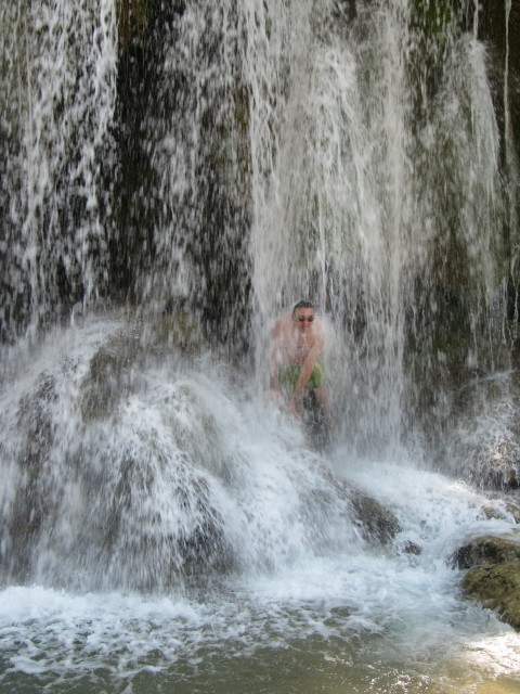
Please upload also a photo of you or your GPS-Device
with Kravica waterfalls.
Bosanski:
Trebižat je rijeka u Hercegovini, u južnom
dijelu Bosne i Hercegovine, duga od svojega izvora u Pec-Mlinima do
ušca u Neretvu u Strugama ukupno 50 km. Ona je nastavak toka
od Posušja (Tribistovo, kota 903), tako da je de facto
susrecemo pod devet imena.
Kravice su vodopad koji se nalazi tri km nizvodno od
Vitaljine, u Studencima blizu
Ljubuškog. Stvoren je radom sedronosne rijeke Trebižat.
Visina slapa krece se od ??? metara, s vodenim amfiteatrom ispod
slapa promjera 120 metara. Preko sedronosna sloja od dna do vrha
slapa izrasla je trava, mahovina, alge i lišajevi. Uz slap
su nikle konopljika, smokve i topole. Nekada su uz slap bili
aktivni mnogobrojni mlinovi i stupe za valjanje sukna.
Sedrena podrucja oko vodopada Kravice spadaju u geološke
spomenike prirode Bosne i
Hercegovine.
Pored Kravica na Trebižatu se nalazi i vodopad
Kocuša.