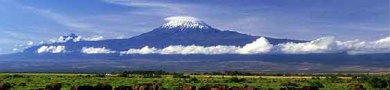
Mount Kilimanjaro is a snow-capped peak rising above the savanna of
eastern Africa, just 200 miles south of the equator. With a summit
of 19,341 feet, this is Africa's tallest mountain.It is also the
world's largest free-standing mountain.
Geography and History
Mount Kilimanjaro was formed about 3 million years ago during the
formation if the Great Rift Valley. Then nearly a million years ago
volcanic activities centered on a few specific points. Kilimanjaro
is not one single mountain peak but rather three volcanoes lying
practically on top of one another. The lowest summit, Shira, at
12,995 feet last erupted half a million years ago and is now
considered extinct. The other two peaks are dormant and have not
erupted for centuries. Mawenzi, at 16,896 feet is linked to the
highest summit, Kibo, by a broad ridge which gives the summit of
Kilimanjaro a “saddle” shape. Researchers believe
Kilimanjaro’s glaciers formed about 11,000 years ago, when
the region was undergoing a period of wet weather that allowed snow
to accumulate.
The coordinate for this Earthcache put you at the Arrow Glacier
Camp at roughly 15,970 feet. This is the edge of the Glacier.
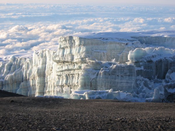
What Is A Glacier?
Glaciers are made up of fallen snow that, over many years,
compresses into large, thickened ice masses. Glaciers form when
snow remains in one location long enough to transform into ice. It
must have a huge basin to collect snow at the top which must stay
at freezing temperatures for many years. What makes glaciers unique
is their ability to move usually 100,000 times slower than a river.
Some glaciers are as small as football fields, while others grow to
be over a hundred kilometers long.
Disappearing Glacier
It is widely known that the Glaciers of Kilimanjaro are
disappearing. This can be seen in several photographs taken over a
period of time. The volcano Kibo is the highest point on
Kilimanjaro, about 19,340 feet above sea level. A rough survey in
1889 suggested that Kibo's icecap occupied about 12.5 square miles.
By 1912, more than two decades before Ernest Hemingway wrote his
masterpiece short story "The Snows of Kilimanjaro," it had dwindled
to about 7.5 square miles. By 1953 it had shrunk to about 4.3
square miles and by 2003 it was at a little more than 1.5 square
miles.
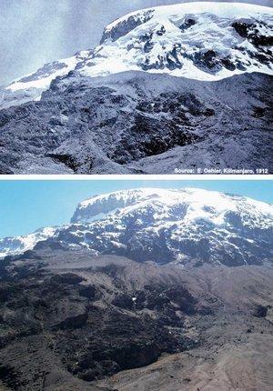
A photograph by Edward Oehler taken in 1912 (top) shows the
extent of the icecap atop Mount Kilimanjaro, and a similar photo
taken in 2006 by Georg Kaser illustrates the icecap's decline.
(Credit: Edward Oehler / Georg Kaser)
Sublimation
Even before the first Europeans reached the summit in 1889, the
weather has been dry in Eastern Africa. Since air near the
mountain's ice almost always is well below freezing, there
typically is no melting. Instead ice loss is mainly through a
process called sublimation, which requires more than eight times as
much energy as melting. Sublimation, caused by exposure to sunlight
and dry air, occurs when ice essentially skips the melting step and
evaporates. This can be likened to moisture-sapping conditions that
cause food to suffer freezer burn.
Log Requirements
You may log this cache and email the answers and coordinates at the
same time. Logs containing any answers to questions will be
deleted. You are not required to put yourself in harm’s way
to answer these questions.
1. Estimate the direction in which this glacier is moving
(approximate) based on physical features you observe.
2. Estimate the height of the Glacier from GZ based on nearby
features and approximations.
3. Look for evidence of the disappearing glaciers (dislodged rocks,
rounded edges, water pools, etc). Include a photo in your log
showing the evidence with the coordinates (optional)
4. Take a photo of the members in your party with the Glaciers in
the background and include your coordinates in your log.
(optional)
Send me an e-mail with #1 and #2.