Tour of Pine Creek Mystery Cache
-
Difficulty:
-

-
Terrain:
-
Size:  (regular)
Please note Use of geocaching.com services is subject to the terms and conditions
in our disclaimer.
This is a multi-stage mystery cache where you'll have to visit a
number of locations in and around Pine Creek to determine the final
set of coordinates for the cache. The hike will be about 14 miles
round trip and you can expect at least 4500' of elevation gain.
Probably about half of the hike will be without a trail. The order
you visit the waypoints is inconsequential and part of your
challenge will be to determine what order will work best for you.
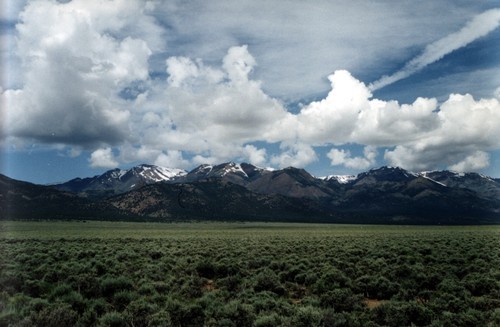
Pine Creek is a perennial stream that drains into the Monitor
Valley. It provides a welcome respite from the hot Nevada sun and
there is a pleasant trail the winds it's way along the edges for a
number of miles up into a small cirque below the Mt Jefferson
ridgeline. We camped at the NFS campground near the mouth of Pine
Creek for a couple of days over the Memorial Day weekend and had a
great time. The campground is in good condition and the price is
perfect (free :) )
At WP1 you will solve for the symbol %. You will find a gourp of
aspen trees that have been defaced by some overzealous knife
wielders. Look for the tree that has three initials carved over the
number 08.
_R_
08
Add the values (A=1, B=2, C=3, etc...) of the two missing initials
together and divide by two. Your answer will equal %.
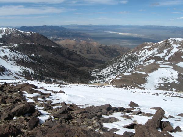
At WP2 you will be on the south summit of Mt Jefferson. Look for a
small building with some I-Beams used to keep the building itself
off of the ground. One of the I-Beams has a series of numbers and
letters stamped on it that look something like this: .
B2 3#2&9$
On the actual I-Beam the symbols #, &, and $; are actually
three different numbers. Replace the symbols with the corresponding
numbers and use them to help determine the coordinates for the
final.
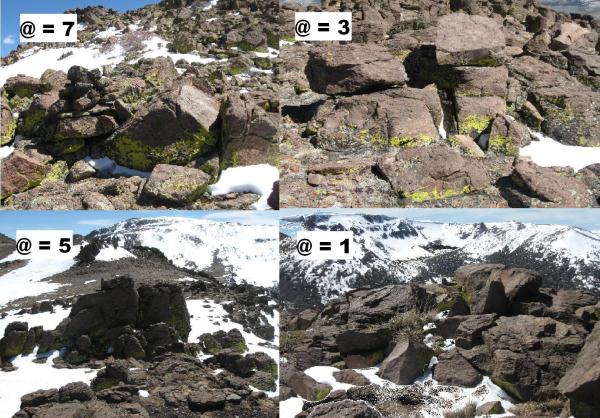
At WP3 you will find yourself standing near one of locations
depicted in a picture below. Use that information to determine the
value of @.
At WP4 you will find a benchmark very near the edge of the trail.
Above the word "Line" there are three words stamped into the metal.
Convert the last letter of the last word to a number (A=1, B=2,
C=3, etc...) and that number will equal *.
At WP5 you'll find something interesting, it is:
1. An aspen tree with multiple sets of initials carved into the
bark (then ? = 1)
2. A piece of metal from an unkown origin (then ? = 5)
3. A man-made cairn (then ? = 3)
4. A large naturally occurring pile of lichen covered rocks (then ?
= 8)
At WP6 you'll find a name carved into a tree above the date 1996,
it is:
1. Aaron (then ! = 2)
2. Susan (then ! = 4)
3. Mike (then ! = 6)
4. Sara (then ! = 8)
5. Randy (then ! = 0)
The cache can be found at the following coordinates: .
N 38 (%-?) & . (!+?) @ %
W 116 (@-$) # . (@+$) (&-#) (?+*)
Additional Hints
(Decrypt)
Vg jvyy yvxryl or rnfvrfg gb cnex lbhe iruvpyr arne gur pnzctebhaq.