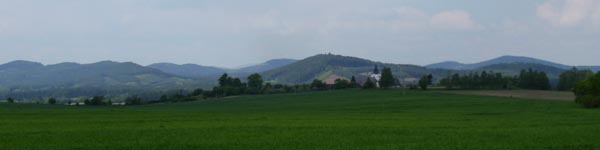
pohled na Sedmihori / view on the Sedmihori
 Listing v Ceském jazyce
Sedmihori
Sedmihori je soustava kruhove rozmistenych kopcu, prevysujicich
okolni teren o 100 – 150 metru. Cely masiv ma v prumeru 4
– 5 km a nachazi se v Zapadnich cechach, asi 10km severne od
Horsovskeho Tyna. Sedmihori je vybornou ukazkou ringove intruze, jednou z
nejlepsich v cele stredni Evrope. Jedna se take o uzemi s nejlepe
vyvinutymi formami zvetravani zuly v cechach.
Prstencove struktury jsou obecne povazovany za smisene
vulkanicko-plutonicke
komplexy, prime dukazy o povrchovych projevech vulkanicke cinnosti
u nich vsak casto chybeji.
Geologicke slozeni

nákres Sedmihorí / sketch Sedmihorí
Od okraje do stredu celeho granoidniho masivu se podstatne meni
jeho mineralni slozeni.
- Vnejsi cast je tvorena porfyrickou biotitickou zulou svetle
sede barvy. zula je stredne zrnita s vysokym obsahem draselneho
zivce (misty az 50%). V zakladni hmote je pritomen kremen,
plagioklas (oligoklas), biotit a zridka muskovit.
- Vnitrni cast tvori biotiticko-muskoviticka zula, belave az
okrove sede barvy, stredne az hrube zrnita. Hlavnim rozdilem oproti
vnejsi casti je stala pritomnost muskovitu a pouze ojedinela
pritomnost draselneho zivce. zivce v teto zule byly slabe postizeny
druhotnymi premenami (kaolinizace, sericitizace), a proto hornina
snadneji zvetrava. To podporuje pokles vnitrni casti.
- Jadro intruze tvori turmalinicko-muskoviticka zula. Je to
drobnozrnna belave seda hornina s drobnymi castmi draselneho zivce
s nizkym podilem slid.
Hranice mezi temito tremi castmi jsou pomerne ostre, ale presto
maji prechodny raz. Svym slozenim se tyto zuly priblizuji
cinonosnym zulam v Krusnych horach.
Vznik masivu
Zvetravani stredni casti by vsak samo o sobe nestacilo k vzniku
takto vyrazne modelace terenu. Vyrazne vystupovani Sedmihori ma
vysvetleni tektonicke. Zatimco cela oblast zapadne od marianskolazenskeho zlomu
poklesla, Sedmihori zustalo v puvodni vysi nebo se mirne zvedlo.
Poklesy okolniho krystalinika se
odehraly podel rady mladsich zlomu, z nichz nejvyraznejsi je
prokazan na jiznim okraji masivu.
Jednotlive kopce, tvorici Sedmihori, jsou oddeleny pomerne
hlubokymi sedly. Jejich vznik je zpusoben vyskytem puklin, ktere
prostupuji zulovy masiv. V mistech, kde jsou pukliny u sebe,
dochazi k rychlejsimu rozpadu horniny a vzniku hlubokych sedel. Ze
stejneho duvodu je cely prstenec otevren na vychodni strane. Tato
strana byla jiz drive narusena marianskolazenskym zlomem a proto
zde dochazi k rychlejsi erozi.
Stari sedmihorskeho pne je
radiometricky datovane na 315-280 milionu let a jeho vznik
nepochybne souvisi s
variskym vrasnenim.
Sedmihori tedy mohlo byt vulkanickym centrem v obdobi svrchniho
karbonu. O projevech vulkanismu z te doby mame radu dukazu v
sedimentech plzenske, radnicke i mnoha dalsich jezernich panvi
karbonskeho stari.
Projevy zvetravani, ktere zde naleznete
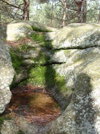
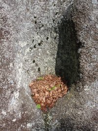
Skalní mísa / Rock bowl
Skalni misy
Kruhovite nebo ovalne prohlubne na hornich castech plochych
skalnich masivu se nazyvaji skalni misy. Vyskytuji se na vsech
typech hornin, nejcasteji vsak na piskovcich. Proto se s nimi take
nejcasteji setkavame v piskovcovych skalnich mestech. Vznikaji v
mistech mensi odolnosti horniny, pusobenim chemickeho i fyzikalniho
zvetravani. Uplatnuje se zde cinnost lisejniku, mechu, mrazu i
atmosferickych vlivu. Vetsina skalnich mis zadrzuje destovou vodu.
Tato voda se postupem casu stava vuci hornine velmi agresivni,
nebot vlivem slunecniho osvitu a obsahu mikroorganismu meni svoje
pH. Vlivem vsech techto faktoru je objem skalni misy stale
rozsirovan a vznikaji tak prohlubne az nekolik decimetru v
prumeru.
Mrazove sruby
Mrazove sruby jsou skalni steny, ktere vznikly roztrhanim a
rozpadem hornin podel prasklin. Podminkou vzniku Mrazovych srubu,
jsou dve na sebe priblizne kolme praskliny. Skrz tyto praskliny
prostupuje voda a soustreduje se zde. Zmrznutim zadrzene vody
vznikaji velke tlaky, ktere nadzvedavaji material nad sebou. Pri
rozmrznuti bloky poklesaji o neco nize nez se puvodne nachazely.
Mnohonasobnym opakovanim tohoto deje dochazi k trhani a ustupu
skalni steny. Takto utrzene bloky postupne sestupuji ze svahu a na
jejich puvodnim miste zustava strma stena - mrazovy srub. Pod nim
se vytvareji mirne uklonene kryoplanacni
plosiny, pokryte suti z rozpadlych skalnich bloku, tzv. kamenna
more.
Pseudokary
Pseudokary maji na rozdil od mrazovych srubu obloukovy prubeh.
Vznikaji stejnymi procesy jako mrazovy srub, avsak skalni masiv
musi mit pukliny ve vice smerech. Pro vznik pseudokaru jsou potreba
minimalne ctyri steny. Pseudokary jsou nejen typicke pro toto
uzemi, ale i velmi pekne na pohled.
Vase ukoly
Aby jste si mohli zalogovat tuto cache, musite splnit nasleduji
ukoly. Nezapomente si vzit metr!
- Vasim ukolem je zmerit prumer Skalni misy (te horni), kterou
naleznete na vychozich souradnicich - (waypoint Sklani misy - N 49°
37.588 E 012° 52.565). Az na misto Vas take dovede modra turisticka
znacka. Namerenou hodnotu odeslete na nas mail, uvedeny v nasem
profilu.
- Dobrovolny ukol - prilozte fotografii pseudokaru mrazoveho
srubu, kamenne misy, kamenneho more nebo jakehokoliv zajimaveho
utvaru, ktery pri Vasi navsteve Sedmihori naleznete.
Vyfotte se u nektereho z mrazovych srubu - (napr.
waypoint Mrazovy srub - N 49° 37.268 E 012° 51.379). Viz ukazkove
foto. Tato podminka byla zrusena aktualizaci pravidel dne
1.1.2011
Cache muzete logovat ihned, neni potreba cekat na potvrzeni
spravnosti odpovedi
 Listing in English
Sedmihori / The Seven Mountains
Sedmihori is a circular arrangement of hills, surmounting the
surrounding terrain by 100-150 metres. The whole massif has a
diameter of 4 - 5Km and is located in Western Bohemia, about 10Km
north of Horsovsky Tyn. Sedmihori is an excellent example of a ring
intrusion, one
of the best in the whole of Western Europe. It is also an area with
the most developed forms of weathered granite in the Czech
Republic.
Ring structures are generally thought to be mixed
volcanic-plutonic formations,
however, direct proof of nearby surface volcanic activity is often
missing.
Geological composition
nákres Sedmihorí / sketch Sedmihorí
The mineral composition of the whole granoid massif changes
dramatically from its edges to its centre.
- The outer part consists of light grey porphyric biotitic
granite. The granite has a medium grain with a high content of
potassium feldspar (in some parts up to 50%). Granite contains
quartz, plagioclase (oligoclase), biotite and, rarely,
muscovite.
- The inner part consists of biotitic-muscovitic granite with a
white to ochre-grey colour and medium to rough grain. The main
difference between this and the outer part is the stable presence
of muscovite and only a trace of potassium feldspar. Feldspars in
this granite were slightly affected by secondary changes
(kaolinization, sericitization) which are why the rock succumbs
more easily to weathering. This supports the sinking of the inner
part.
- The core of the intrusion consists of tourmaline-muscovitic
granite. This is a finely grained white-grey rock with minute parts
of potassium feldspar and a low content of mica.
The borders between these three parts are relatively sharp,
however, despite this there is a gradation between them. The
content of these granites makes them very similar to tin-containing
granites in the Krušný Mountains.
Massif formation
Weathering of the middle part would not have been sufficient,
however, for the formation of such distinct terrain. The distinct
shape of Sedmihorí is due to tectonics. While the whole area west
of Mariansbad fault sank, Sedmihorí remained at the same elevation
or was slightly raised. Sinkings of the nearby crystalinic areas
occurred parallel to the younger fault lines, most notably on the
southern edge of the massif.
The hills of Sedmihorí are divided by relatively deep saddles.
They were formed due to the presence of cracks throughout the
granite massif. The breakdown of rock in areas where cracks are
close to each other is quicker than in other areas and results in
the formation of deep saddles. For this reason there is an opening
on the east side of the ring formation. This side was affected by
the Mariansbad fault which is why it is subject to faster
erosion.
The age of Sedmihorí is radiometrically dated to be 315-280
million years and its formation is undoubtedly linked to the
Variscan orogeny.
Therefore, Sedmihorí could have been a volcanic centre in the
late Carboniferous (Pennsylvanian) period. We have much evidence
supporting volcanic activity from Pilsen, Radnice and many other
lake basin sediments from this period.
Examples of weathering patterns which you will find here
Skalní mísa / Rock bowl
Rock bowls
Circular or oval depressions on the upper parts of flat rock
massifs are called rock bowls. They are found on all types of
rocks, however, they are most commonly found on sandstone. This is
why we often find them on limestone rock formations. They form in
areas where rock has been weakened due to chemical and physical
weathering – caused by lichen and moss activity, freezing and
atmospheric factors. Most rock bowls collect rainwater. This water
becomes a serious factor in the weathering of rock bowls as
sunlight and the presence of microorganisms change its pH. This
causes the rock to widen over time which is how rock bowls as wide
as several decimetres are formed.
Frost weathering
Frost weathering are rock walls which formed by the tearing and
breaking down of rock along crack lines. Two approximately
perpendicular cracks are needed for the formation of rock
weathering. Water gets into the cracks and stays there. The
freezing of this water creates great pressure as water expands when
it freezes causing the rock either side of the crack to be pushed
apart. After the water melts, the rock moves down a little further
than it originally was. Repetition of this causes tearing and
recession of the rock wall. Blocks of rock which are torn off this
way gradually move downward and in their place is a steep wall
– Frost weathering. Crayoplanation plateaus are formed under
this, covered with ruins of broken blocks of rock, a so-called
scree.
Pseudokar
In contrast to Frost weathering, Pseudokars have a curved shape.
They are formed by the same processes as Frost weathering but the
rock must have cracks in various different directions. A minimum of
four walls are needed for the formation of Pseudokars. Pseudokars
are not only typical for this country but also beautiful to look
at.
Your tasks
In order for you to be able to log this cache, you must fulfil
the following tasks. Don’t forget your tape measure!
- Your task is to measure the diameter of the rock bowl (on the
top) which you find at the starting point which has the following
coordinates (waypoint rock bowl - N 49° 37.588 E 012° 52.565). A
blue tourist sign will also lead you to this starting point. Send
the rock bowl measurement to us via the email address on our
profile.
- Optional task – attach a photograph of a pseudokar, frost
weathering, stone sea etc.
Take a photo of yourself at one of the Frost weathering
– (e.g. waypoint Frost weathering - N 49° 37.268 E 012°
51.379). See sample photo. Edit because of new rules from
1.1.2011
You may log the cache immediately; there is no need to wait for
confirmation that your answer is correct.
Za preklad velmi dekujeme nasi kamaradce Sente
Shand.