|
Penha de
Prados [Celorico da
Beira]
(Vistas, para e da, Penha
de Prados)
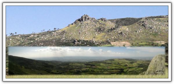
[PT] A Penha de
Prados, património natural, ocorre sobre um imponente Tor granítico
a 1152 m de altitude e pode ter sido, talvez, um antigo castro
pré-histórico. Constitui um miradouro natural, dominando uma vasta
região deprimida que ronda a cota dos 500 m, por onde corre o Rio
Mondego. Neste local o granito apresenta-se porfiróide biotítico de
grão médio, idêntico ao granito em que assenta a povoação e Castelo
de Linhares situado a SW. Repare-se que a serra se eleva desta
plataforma deprimida ao longo da grande falha Seia - Lousã de
direcção NE/SW que marca o início da elevação a norte da Serra da
Estrela. Este local é igualmente, atravessado pela falha Vilariça -
Manteigas de direcção NNE/SSW, que é bem evidenciada na paisagem
pelo alinhamento dos vales das ribeiras que atravessam a região. O
próprio Rio Mondego apresenta o seu leito marcado por alinhamentos
com estas duas direcções, evidenciando controlo tectónico do seu
traçado. Ao longe, a povoação de Fornos de Algodres, situada a meia
encosta na vertente oposta, marca igualmente o controlo tectónico
na morfologia da região.
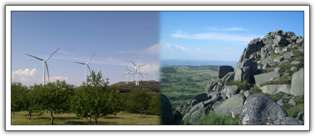
A zona onde se insere
a Penha de Prados faz a transição do andar basal para o andar
intermédio da Serra, numa paisagem profundamente humanizada, onde
pequenos bosques de carvalho-negral (Quercus pyrenaica), como os
situados a norte de Linhares e a nordeste de Prados, coexistem com
manchas de carvalho-roble (Quercus robur) e antiquíssimos soutos de
castanheiros (Castanea sativa). Tufos de Armérias e Narcisos
espalham-se pela paisagem.
Aqui ganham vida as
crenças animistas dos lusitanos, que acreditavam na permanência das
almas no sopro dos ventos, surgindo em cada recanto encruzilhadas,
nascentes e cumeadas que o cristianismo sacralizou, cruzes e
alminhas. Ali ao lado as modernas tecnologias das energias
renováveis fizeram erguer um moderno parque eólico (da Serra do
Ralo).
[EN]
“Penha de
Prados”, natural patrimony of Portugal, is a huge granitic
“Tor” situated at 1152 meters above sea level, and may
have been, perhaps, an old fort prehistoric. It’s a natural
viewpoint over a vast depressed region at about 500 meters above
sea level where flows the “Mondego” river. Here the
granite type is “porphyritic biotite” and presents an
average grain, similar to the granite on which the town and castle
of “Linhares” is built in, located at SW. Notice that
the mountain rises from this depressed platform along the great
fault “Seia – Lousã”, NE / SW targeted, which
marks the beginning of the north rising of the “Serra da
Estrela”. This site is also crossed by the fault
“Vilariça – Manteigas” in the NNE / SSW
direction, which is quite evident in the landscape by the alignment
of the valleys that cross the region. The “Mondego”
river, itself, flows according those two directions, indicating a
tectonic control layout. By far, the village of “Fornos de
Algodres”, located halfway up the opposite slope, also marks
the tectonic control of the region morphology.
The area where are
situated the “Penha de Prados” makes the transition
from the basement to the intermediate floor of the mountain range,
on a deeply humanized landscape, where small woods of black-oaks
(Quercus pyrenaica), such as those located at north of
“Linhares” and northeast of “Prados”,
coexist with several spots of oak-“roble” (Quercus
robur) and very old chestnut trees (Castanea sativa). Tufts of
Thrift and Daffodils are scattered over the landscape.
Here Lusitanian
animistic beliefs are brought to life. They believed that the dead
people souls remained on the blowing winds, and so it appears in
every corner, intersections, springs, and ridges that Christianity
sacralized, crosses and shrines (Alminhas). Near, the modern and
renewable energy technologies have razed up a modern wind farm
(Ralo mountain).
A cache vai levá-lo a este
belo miradouro natural, ao qual se acede por um, razoavelmente bom
e largo, estradão (N 40º 32.699' - W 007º 23.610') com cerca de 2,8
Km. Divirtam-se.
The cache will take you to
this beautiful and natural viewpoint, which can be reached by a
reasonably smooth and wide, dirt road (N 40º 32.699' - W 007º
23.610') approximately 2,8 Km. Enjoy.
Conteúdo inicial: Berlinde,
cavalinho, suporte de secretaria, conjunto de lápis de cera, anilha
"CMatos"
|