Reeds Peak Traditional Geocache
-
Difficulty:
-

-
Terrain:
-

Size:  (regular)
Please note Use of geocaching.com services is subject to the terms and conditions
in our disclaimer.
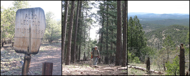
This cache is placed on Reeds Peak, a 10,015' mountain summit in
the Aldo Leopold Wilderness area of the Gila National Forest's
Black Range. The route described involves a ~13 m hike ONE WAY to
the summit. Hence, most cachers will want to spend the night on the
peak. There is an old cabin there which you can stay in if you want
to but bring a tent just in case. There is also a lookout tower
which you are permitted to go up into and have a look around. You
can't count on there being any water on the peak or the trail so it
is important to pack enough water--and food--for your
journey.
From NM-35, turn on North Star Rd. (NM-61, FR-150)--a nicely-graded
road--and travel for about 8 miles until you see a sign telling you
to turn right for the trailhead to Trails #74 and #77. Turn right
and follow the road about 3/4 m to the trailhead. (This road may
require high clearance.)
Start hiking at the trailhead but after .4 miles the trail splits
and you will have to choose one to follow as both head toward Reeds
Peak. Continental Divide Trail #74 takes immediately to higher
ground heading up ridges and bypassing smaller summits on the way
to the peak while Mimbres River Trail #77 stays in the canyons and
primarily follows the course of the river, eventually intersecting
Crest Trail #79 where you'll head north toward the peak.
Keep in mind that this is the wilderness and it is very remote.
There is no cell service and you will likely not see another human.
Remember to be respectful of the land by putting out your fires and
packing out your trash. Enjoy your trip and be sure to keep an eye
out for wildlife.
Additional Hints
(No hints available.)