Kittanning Overlook EarthCache EarthCache
Kittanning Overlook EarthCache
-
Difficulty:
-

-
Terrain:
-

Size:  (other)
Related Web Page
Please note Use of geocaching.com services is subject to the terms and conditions
in our disclaimer.
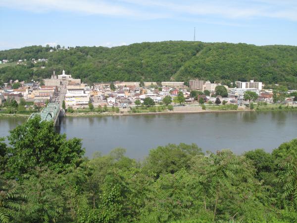
This earthcache will take you to a beautiful overlook of the town of Kittanning and from the overlook you will be able to see how the town sits on a flood plain. A floodplain is flat or nearly flat land adjacent to a stream or river that experiences occasional or periodic flooding. The cache coordinates is a reference point only for parking and getting you to the overlook area. There is no cache container hidden in the area.
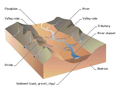
A valley formed by flowing water, or river valley, is usually V-shaped. The exact shape will depend on the characteristics of the stream flowing through it. Rivers with steep gradients, as in mountain ranges, produce steep walls and a narrow bottom. Shallower slopes may produce broader and gentler valleys, but in the lowest stretch of a river, where it approaches its base level, it begins to deposit sediment and the valley bottom becomes a floodplain.
Kittanning was an 18th century Native American village called Kit-Han-Ne was built on a floodplain of the Allegheny River. The village was at the western terminus of the Kittanning Path, an Indian trail that provided a route across the Alleghenies between the Ohio and Susquehanna river basins. The village, inhabited by Delaware (Lenape) and Shawnee Indians, was most likely the largest such village on the western side of the Alleghenies at the time, having an estimated 300–400 residents in 1756. Kittanning was settled in 1724 by Indians who had migrated from eastern Pennsylvania as white settlement rapidly expanded. The name means "at the great stream" in the Delaware language. During the French and Indian War, Kittanning was used as a staging point for raids by Delaware and Shawnee warriors against British colonists in the Juniata River valley in central Pennsylvania. In response, Lieutenant Colonel John Armstrong led Pennsylvania militiamen on the Kittanning Expedition, which destroyed the village on about 8 September 1756.
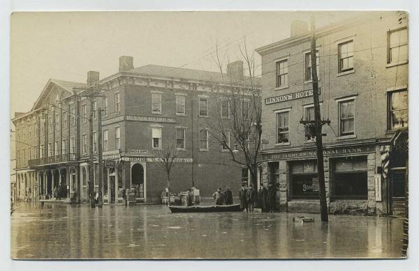
Floods have taken its toll in Kittanning through out many years recorded as early as 1832.
Flood Categories (in feet)
Major Flood Stage: 23
Moderate Flood Stage: 22
Flood Stage: 21
Action Stage: 17
The following are historical crests at Kittanning
(1) 30.70 ft on 03/26/1913
(2) 24.80 ft on 03/10/1964
(3) 24.60 ft on 01/22/1959
(4) 24.20 ft on 03/18/1936
(5) 23.70 ft on 06/23/1972
(6) 23.70 ft on 12/30/1942
(7) 22.70 ft on 01/20/1996
(8) 22.20 ft on 09/18/2004
(9) 22.20 ft on 02/14/1966
(10) 21.70 ft on 02/20/1981
Several flood control projects lie farther upstream on the river and its tributaries. One of these flood control projects is the Kinzua Dam and Allegheny Reservoir near Warren, Pennsylvania. When a storm hits, multi-purpose flood control reservoirs built and maintained by the Corps of Engineers retain excess water upstream of the dam. Controlled releases of this excess water prevent or reduce downstream flooding. Another unique problem occurs in the winter and spring along the river at Oil City, Pennsylvania. that requires a unique solution in the form of local flood protection ice control structures. Without Corps reservoirs, the Flood of January 1996 would have raised the crest at The Point in Pittsburgh by 9.7 feet and during the September 2004 flooding, the crest at The Point of 31.1 feet would have been 7.7 feet higher. Pittsburgh District reservoirs also proved their effectiveness during the June 1972 flooding when without Corps reservoirs the crest at The Point would have been 47.9 feet – 1.9 feet higher than the devastating St. Patrick’s Day Flood of 1936.
Water levels for the Allegheny River are predicted daily by the National Oceanic and Atmospheric Administration (NOAA). The water depth predictions are relative to each local flood plain based upon predicted rainfall in the Allegheny River basin.
Shortcut to National Oceanic and Atmospheric Administration (NOAA):
The U.S. Army Corps of Engineering constructed eight locks and dams on the Allegheny in the 1920s and 1930s. They guarantee a minimum 9-foot navigation channel for 72 miles from Pittsburgh to East Brady, Pennsylvania, and cost about $5 million annually to operate and maintain. These dams were not built for flood control, they were built only for navigation. Depending on where you stand at the overlook, you may see Lock and Dam #7.
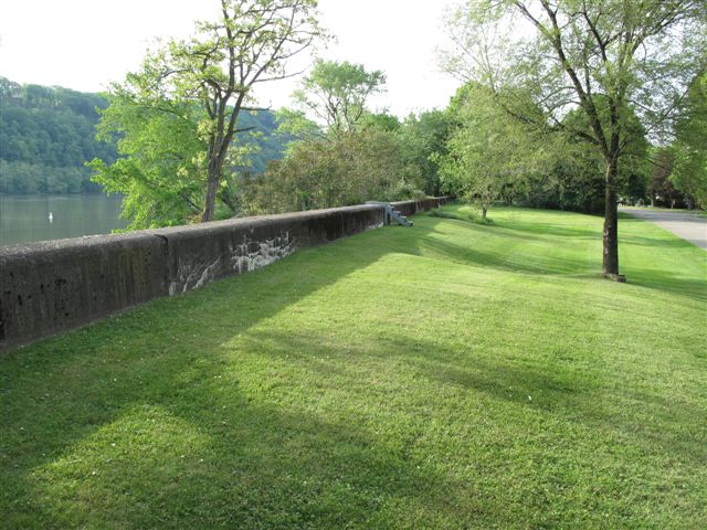
Because the water level was raised above Lock and Dam #7, the U.S. Army Corps of Engineers built a flood wall in Kittanning with a combination of federal, state and local money in response to the devastation of the 1936 flood. They have determined the condition of the Kittanning flood wall, built in 1940, is "unacceptable." It is one of three such structures in Western Pennsylvania rated as unacceptable as part a nationwide survey to determine the safety of levees in the post-Hurricane Katrina world. At nearly 67 years old, the Kittanning flood wall is the oldest. The flood wall stretches from just south of Dam No. 7 and north along Water Street, from Rebecca to Ewing streets.
The other two levees that are in danger are in Oil City, Venango County, and Vintondale, Cambria County.
Coordinates will take you to a very popular sightseeing area that you may look down upon the town of Kittanning. It's near the intersection of Bluff Street and Southern Street where public curb side street parking is available. Do not park in the grassy areas or in front of any driveways. The mowed grassy area is on homeowner's land so please respect how all the owners have taken care of the area for you to enjoy the view. You may look upon Kittanning anywhere along Bluff Street. Each spot has it's own unique view. Please practice CITO (Cache In Trash Out) This area is beautiful at night.
In order to successfully log this cache, you must complete two out of the three tasks:
1.) The posted coordinates are for the general overlook area. To prove you were here, take a picture of yourself or your GPS anywhere along Bluff Street with the town below in the background. Then attach it to your log when you are logging this cache.
2.) The Allegheny River's normal pool level is 769 feet above sea level. Using your altimeter on your GPS, Email me the difference in elevation between where you are standing at the overlook and the river. If you don't have an altimeter, then a good estimate will work. Do not put the answer of the elevation difference into your log. If you post the difference in your log, your log will be deleted.
3.) Looking down from the overlook at Kittanning, tell me how you view the height of the river. Using the walkways, lamp post or the stairs located in the community park below as a reference, let me know the status of the river whether the river level looks normal to you, or is the river flooding into the park or ever worse, if there is flooding into the town streets the day that you were there.
The most exciting way to learn about the Earth and its processes is to get into the outdoors and experience it first-hand. Visiting an Earthcache is a great outdoor activity the whole family can enjoy. An Earthcache is a special place that people can visit to learn about a unique geoscience feature or aspect of our Earth. Earthcaches include a set of educational notes and the details about where to find the location (latitude and longitude). Visitors to Earthcaches can see how our planet has been shaped by geological processes, how we manage the resources and how scientists gather evidence to learn about the Earth.
Congratulations hbowser with FTF. May he rest in peace!
Additional Hints
(Decrypt)
Erzrzore gb oevat lbhe pnzren