KARST, CACHE AND CAMEL (MALLORCA) EarthCache
KARST, CACHE AND CAMEL (MALLORCA)
-
Difficulty:
-

-
Terrain:
-

Size:  (other)
Please note Use of geocaching.com services is subject to the terms and conditions
in our disclaimer.
Edit 23.6.2012: In main season the parking area seems to cost newly four Euros.
Edit 5.10.2013: The parking costs 6 Euros by now!
Edit 31.3.2016: Even in low season the parking costs 6€!
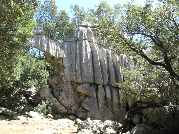
This Earthcache guides you through the karst around the monastery of Lluc to a bizzare stone formation with the shape of a camel, which is called "ES CAMELL".
Use the parking area of the monastery Lluc (free parking).
For the trip and return calculate about 40 minutes including the nearby cache "Steinkamel".
Geology:
Mallorca consists up to 90% of limestones. Before the big continantal drifts in the late middleages of earth the island was a hugh flat area. Because of the continental drifts the hugh carbonate stones ( depositions of the Trias and Jura area) were torn to pieces and pushed on top of each other, so that the Tramuntnana folded upwards. Through tectonical influences the stones were transported from their original place and tilted. The steep slopes point to Northwest and build there those markant cliffs. The flattenings out point to Southeast and move on to the central basin.
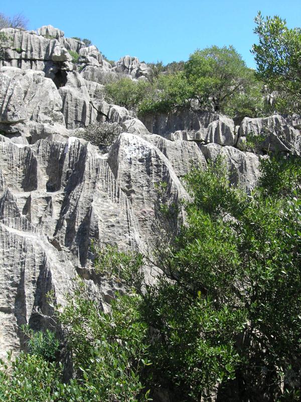
Karst is called a landscape shaped by the dissolution of a layer or layers of soluble bedrock, usually carbonate rock such as limestone or dolomite. Those compact limestones are at the surface often in a caracteristical pattern of grooves and ridges which are called Stripes = Karren = Grykes or Doline = Sinkhole = bowl. At first there is a chemical exhaustion, which will later erose further under the mechanical influences of spray, rain and meltwater. Karst landforms are generally the result of mildly acidic water acting on soluble bedrock such as limestone or dolostone. The carbonic acid that causes these features is formed as rain passes through the atmosphere picking up CO2, which dissolves in the water. Once the rain reaches the ground, it may pass through soil that may provide further CO2 to form a weak carbonic acid solution: H2O + CO2 ? H2CO3 (the acid). This mildly acidic water begins to dissolve the surface along with any fractures or bedding planes in the limestone bedrock. Over time, these fractures enlarge as the bedrock continues to dissolve. Openings in the rock increase in size, and an underground drainage system begins to develop, allowing more water to pass through the area, and accelerating the formation of underground karst features.
The Karst at this side belongs to the type "Merokarst", which is typical for Middle- and Westeurope containing a lot of karren and sinkholes. Besides this there are a lot of trees growing through the sinkholes, so that this formation is also called "green karst".
"Es Camell" is a rock made by erosion in the shape of a camel (beause we are broiler I consider the shape be mostly like a big hen ).
).
Description of your path:
Take waypoint R1 to find the entrance to the sports field. After croosing the field (exit: almost left corner at the oposite side) go over the bridge (R2). Shortly after the brigde you have to climb a little bit into the karst for your first task (Q1). Afterwards search for R3 (from the bridge a bit to the left), there begins the trail which leads you upwards. Don't miss looking back from time to time for having a nice view towards the mountains at the other side of the road. If you need a rest, take the karst bench at R4 or go straight ahead to R5. This is where the path to Es Camell braches off. You will find the camel at the headcoordinates. There you have to fulfil two more tasks (Q2 & Q3) (and to find the cache Steinkamel) before taking the same way back.
In the little office near the parking area you can get a free map of the trail.
To log this cache as a found you have to send me an e-mail via GC telling me the awnsers for tasks 1-3:
1.) At Q1 (N 39° 49.379 E 002° 53.377) measure the width of the little stripes and the width of the bigger one which contain the small ones.
2.) At Q2 (N 39° 49.416 E 002° 53.439) you will see an arch. Estimate the length and the width of the gap.
3.) Go behind the camel to Q3 (N 39° 49.425 E 002° 53.440). Tell me, if there are stripes and if, compare there width with your measurement of Q1.
4.) Edit 2.8.21: Foto-upload of you, part of you, your GPSr... in front of the camel in your online-log is required (re-allowed by GC since June 2019)
Found-Logs without the required e-mail will be deleted without comment. Do not wait for log-permission, just log your found directly after sending the mail; we will contact you if there is something wrong.
Und falls dies mindestens dein vierter unserer Mallorca-Caches sein sollte, darfst du unsere MallorGeoCoin discovern. Code in unserem Profil.

Additional Hints
(Decrypt)
Sbe cncreyrff pnpuref: Gnfxf: 1.) D1: Zrnfher gur jvqgu bs gur fznyyre naq ovttre fgevcrf. 2.) D2: Rfgvzngr gur qvzrafvbaf bs gur tnc. 3.) D3: Ner gurer fgevcrf ng gur onpxfvqr naq vs, pbzcner gurve jvqgu jvgu gubfr bs D1. 4.) Cubgb