This earthcache is located at the Poverty Point World Heritage Site and was developed with the full cooperation and permission of the Park Manager and with assistance provided by personnel in the Park Museum. Please be very respectful of this priceless historic site and enjoy your visit. The park is open 9 am to 5 pm daily and is closed Thanksgiving, Christmas and News Years Day. There is a $4 per person entry fee to be paid at the Museum. Make sure and ask for the driving tour guide brochure, it will be needed for the cache tour
 For 100 years, the National Park Service has preserved America’s special places “for the enjoyment, education, and inspiration of this and future generations.” Celebrate its second century with the Find Your Park GeoTour that launched April 2016 and explore these geocaches placed for you by National Park Service Rangers and their partners.
geocaching.com/play/geotours/findyourpark
Geology and The Formation of Macon Ridge
Several times in the history of the earth huge sheets of ice, or glaciers, covered large portions of its continents. The most recent episode of glaciation, the Pleistocene epoch, is commonly referred to as the Ice Age and began approximately 1.6 million years ago.
As the glaciers moved south they scraped and bulldozed rock and soil in front of them, and ground and crushed the material beneath them. Soil and rock that was pushed in front of the glaciers, or dropped as they melted, commonly formed long ridges called moraines. Moraines are a common feature in the midwestern and northern U.S. Many of the boulders scattered throughout the region are granites carried down from Canada. In fact, diamonds that were transported south from an as yet undiscovered source in Canada, have been found in the Great Lakes region of the U.S. Exposed bedrock in many places has long scratches, or striations, that were formed as the glaciers, carrying an assortment of rocks from other areas, ground over the bedrock. This grinding also produced large quantities of gravel, sand, and silt. An unsorted mixture of these materials brought by the glaciers is called till, which forms much of the soil of the northern states.
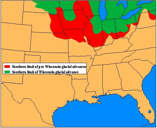
The southern limit all of the glacial advances, not including the Rocky Mountains, is approximately the present day location of the Ohio and Missouri Rivers, although the last (Wisconsin) advance did not reach as far south as some of the previous advances. The glacial advances and retreats also had a dramatic effect upon the geology and ecology of areas south of the glaciers. It took so much water to form the glaciers that the world sea level fell approximately 140 meters (425 feet). This exposed the flat continental shelves, now covered with water, as dry land. This lowering of sea level has the same effect as raising the land, which caused rivers to begin eroding deep valleys.
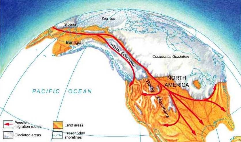
This land bridge, more than 1000 miles wide, was the pathway in which the ancestors of Poverty Point people first came to North America. Several times during the periods of glacial advance, an ice-free corridor remained open through Alaska and Central Canada. Over thousands of years, men and animals traveled this corridor and men gradually spread over North America and southward into Central and South America.
The Lower Mississippi, Tombigbee-Alabama, and Red River systems formed deep cuts in the existing land surface. As the glaciers melted and sea levels rose again, the valleys were filled with sediment carried by meltwater-swollen rivers. Most of the melt water south of the glaciers flowed into the Upper Mississippi, Ohio, and Missouri River basins. This sediment laden water fed into the Lower Mississippi River forming a huge flood plain that is over 500 miles long, and in some places almost 200 miles wide, which is often referred to as the Mississippi Delta.
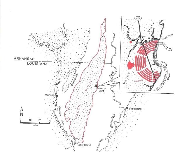
The Poverty Point site is located on the eastern edge of a long, linear terrace known as Macon (pronounced May-sun)) Ridge. Macon Ridge extends approximately 100 miles from eastern Arkansas southward into Louisiana. Macon Ridge is a terrace situated between the Mississippi River Valley to the east and the Arkansas and Ouachita River Valleys to the west. The general north to south pattern of Macon Ridge resulted from floodwaters of melting Midwestern glaciers deposited sand and silt also known as glacial outwash. About 12,000-14,000 years ago, soils blown by the wind covered Macon Ridge adding 15 feet to its surface. This wind blown soil is called loess (pronounced luss).
The Mounds
Poverty Point is a major archaeological mystery. The mystery centers on the ruins of a large prehistoric Indian settlement, the Poverty Point site. There on a bluff top overlooking Mississippi River swamplands in northeastern Louisiana is a group of artificial mounds and embankments. It is not the earthworks themselves that are so mysterious. Eastern North America is, after all, the land of the “Mound Builders”. These people once were thought to be highly advanced, extinct race, but now are known to be ancestors of Native Americans, such as the Creek, Choctaw, Shawnee, and Natchez. The real mystery lies in the size and age of the earthworks. They are among the largest native constructions known in eastern North America, yet they are old, older than any other earthworks of the size in the Western Hemisphere.
At least four distributaries of the Mississippi River, including Bayou Macon, Joe’s Bayou, Tensas Bayou and Tensas River were situated near the Poverty Point site. The proximity of the site to numerous rivers is the basis for the prevailing theory about the organization of Poverty Point trade exchange. Long distance trade was a hallmark of Poverty Point culture. Stones were moved over long distances, some up to 1,400 miles. Rocks were the major trade goods and furnished the raw materials for many tools.Some of the stone they used came from the Ohio and Tennessee river valleys. Soapstone for pots came from the Appalachian foothills of Georgia and Alabama. Some were traded in a natural unaltered condition, but many were circulated as finished or partly finished artifacts.
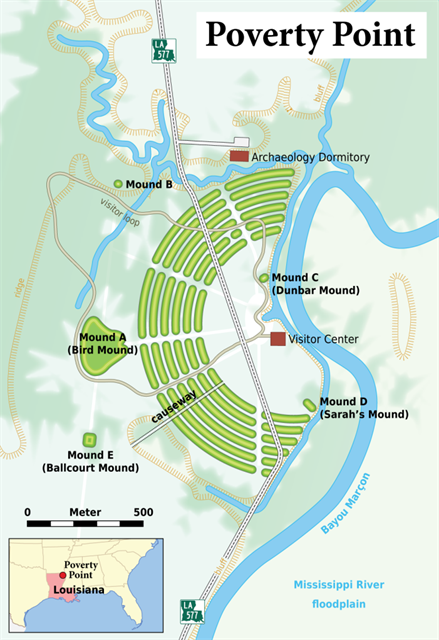
The Poverty Point inhabitants built a complex array of earthen mounds overlooking the Mississippi River flood plain. This accomplishment is particularly impressive for a pre-agricultural society. The central construction consists of six rows of concentric ridges, which at one time were five feet high. The five aisles and six sections of ridges form a partial octagon. The diameter of the outermost ridges measures three-quarters of a mile. It is thought that these ridges served as foundations for dwellings although little evidence of structures has been found.
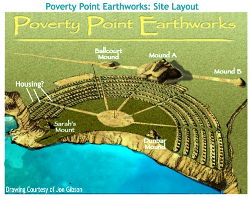
Outside the ridged enclosure are other mounds and embankments. The largest and most unusual is Mound A, located just beyond the outer ridge in the western part of the enclosure. This mound, thought to represent a flying bird, stands more than 70 feet high and measures 640 feet along the wing and 710 feet from head to tail. The flattened, or tail section of the huge structure was built in a depression some 12 or more feet deep. Two other mounds are within the Poverty Point Historic Site. About .4 miles north of Mound A is a doomed mound, known as Mound B, which is about 180 feet in diameter and 20 feet high. Mound C appears to be an oval shaped conical mound near the center of the plaza along the bluff overlooking Bayou Macon., only a remnant of the mound remains.
A team of geoarchaeologists have studied the Poverty Point site and particularly Mound A. (Geoarchaeology is a multi disciplinary approach that uses techniques and subject matter of geography, geology and other Earth sciences to examine topics which inform archaeological knowledge and thought.) This team determined that the total amount of earth moved to build the Poverty Point site was 665,163-764,555 cubic feet (or about 75 million cubic yards of soil). Considering that this feat was performed with manual labor utilizing most likely baskets to carry the dirt, this was a major accomplishment. The geoarchaeological team evaluated Mound A and based on testing and core samples determined that this mound was constructed in 3-6 months. Another extraordinary feat when you look at the dimensions of the mound noted earlier and understand that this mound is the second largest mound in North America that covers an area of at least 6 acres
To get credit for this earthcache you must answer the following questions at each of the locations noted. Do not post your answers to the cache page, please email them to me in order to get credit for your find.You will also have to post a photo of you and/or your GPS at the top of Mound A.
These questions and waypoints are on the vehicle tour and you can drive to each of sites and find the answers to the questions on the information boards along the way.
Waypoint 1 Mound C N 32 38.259 W 091 24.257
What is the length and height of Mound C?
Waypoint 2. Edge of Macon Ridge N 32 38.281 W 091 24.232
Walk a short distance East from the first Waypoint. You will cross the very old Floyd Trace, the sunken area which is a piece of an old 19th Century roadway. Once you cross that you will see the Blue-topped Post #22, which is on the hiking trail. The coordinates will take you North of the post about 10-15 yards to the edge of the Macon Ridge. Look at this area carefully and tell me in your own words what geologic event is causing the loss of the East Side of Mound C and the loss of Macon Ridge.
Waypoint 3. Mound B N 32 38.448 W 091 24.650
In 1955 there were 3 trenches excavated from Mound B that altered its shape. Who did that? (Name).
Waypoint 4 Mound A N 32 38.115 W 091 24.677
The coordinates will lead you to the top of Mound A. Take a photo of you and/or your GPS in front of the frame that held the informational sign. Post this photo with your log. (If for some reason that you are unable to climb to the top, I will accept a photo of you and/or your GPS at the bottom steps beside the blue topped trail post #10 with the mound in the background.)
Waypoint 5. Ridge 1 Southwest Ridges N 32 38.074 W091 24.363
The Southwest sector of the ridges is sometimes called what?
Please email me the answers to the questions and be sure to post a photo of you and your gps with your log. I hope you enjoyed your visit to Poverty Point and the earthcache.
|
| I have earned GSA's highest level: |
 |