VODNINY FINAL
UPOZORNENI:
1. Indicie nelze dohledat pri stavech vody nad 1. povodnovy stupen (odkaz).
2. Cache je nalezci velmi casto umistovana mimo svoji puvodni skrys. Zadam o dusledne vraceni na puvodni misto! V pripade problemu mne prosim kontaktujte.
3. Od podzimu 2010 doslo k mensi mistni uprave. Byla provedena zmena znaceni indicii, ktera by vsak nemela mit vliv na dalsi vypocet.
Cache není umístena na uvedených souradnicích. Souradnice Vás zavedou k prehrade Les Království. Jedna se o finalku serie VODNINY. Pro její vylusteni budete muset odlovit nasledujici tradicky:
cache GC27T4P VODNINY DEBRNÉ
cache GC26TFH VODNINY VERDEK
 Co to jsou VODNINY?
Vodniny je mnou použitý netechnicky termín, který kdysi dávno pouzival muj kamarád pro merení stavu vody na našem táborišti. Dovolil jsem si tento název vypujcit pro toto historické zarízení pro merení stavu vody na Labi.
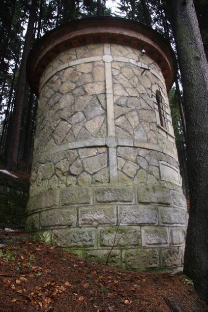
Kamenná budova „VODNIN“ se nachází na levém brehu Labe, stanicní kilometr 316,4 (tj. délka toku ke státní hranici v Hrensku, dle nové administrativní kilometráže Labe platné od 1.10.2009 to je 1040,999 km), nadmorská výška nulového bodu meridla je 294,44 m.n.m. Budova se podobá spíše vežicce hradu. Architektonicky použitím pískovce stavba pripomíná samotnou prehradu Les Království, byla však postavena daleko dríve, údajne již v roce 1903 (sedm let pred zahájením stavby prehrady) jako místo sledování stavu Labe a shromaždování informací o prutocích potrebných prave pro stavbu plánované prehrady.
Limnigraf
Správný technický termín tohoto zarízení je LIMNIGRAF. Zarízení pro merení prutoku vody na základe výšky okamžité hladiny pri známem obsahu profilu koryta v daném míste.
Historie a soucasnost
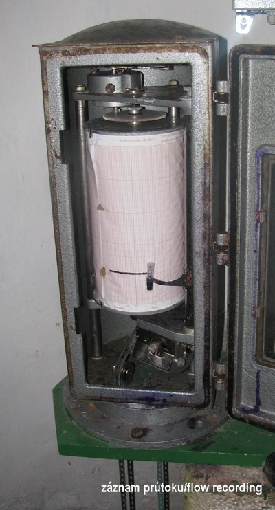
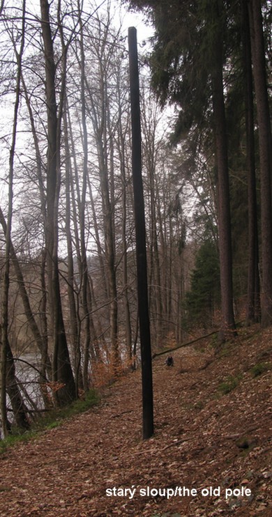
Prestože je budova limnigrafu historickým objektem postaveným na zacátku 20. století, jedná se doposud o funkcní a využívané zarízení. Výška hladiny je snímána z plováku a mechanicky prenášena do zaznamenávacího zarízení a inkoustem je porízen trvalý zápis na grafický papír - viz foto zarízení. V minulém století po dostavbe prehrady byly údaje o výšce hladiny rovnež prenášeny elektricky pres telefonní linky prímo hráznému, který mel stálý prehled o výtoku vody z prehrady a z dalších dvou stanic informace o prítoku do prehrady a stavu vody v samotné prehrade. Zbytky tohoto vedení mužete ješte dnes videt kousek proti proudu reky (N50°27.348´ E015°46.266´) - zustal zde jeden ze sloupu tohoto vedení. (bohuzel od kvetna 2012 je zde jen pozustatek sloupu -"parez". Ukradeno mistnimi zlodeji dreva!!! Doufam, ze pomoci souradnic parez najdete.)
Nebojte se, že by spolecnost povodí Labe s.p. nevenovala pozornost novotám, moderní technika dospela i do techto „hlubokých lesu“ a v soucasné dobe zde funguje ješte paralelní odecet stavu, který pomocí elektronických cidel podává informace o aktuálním stavu Labe bezdrátove na centrální dispecink. Vy si jej mužete prohlédnout on-line na stránkách Ceského hydrometeorologické ústavu.
Hlásná a predpovední povodnová služba
Na míste si mužete prohlédnout jakým zpusobem jsou na ceských rekách znaceny jednotlivé povodnové stupne aktivity. Každý stupen má svoji barvu a odpovídá mu výška hladiny a prutok v m3/s.
Bdelost-zelená 1.stupen
Pohotovost-zluta 2.stupen
Ohrožení-cervena 3.stupen
 Pro zajímavost si všimnete, kde se nacházela voda pri velké povodni v 9. brezna 2000, hladina je oznacena modrým pruhem. Uroven hladiny byla 369 cm a prutok zhruba 50 krát více než je bezny zdejsi stav nebo tolik vody kolik tece v prumeru v Labi, v miste kde opousti Ceskou republiku. Více informaci o hlasne a povodnove sluzbe zde.
Blízké okolí
Jen pro zajímavost naproti pres reku se nachází tzv. Losuv lom, který zásoboval kamenem stavbu regulace reky ve Dvore Králové n.L.. Lom je pojmenován po Ing. Antonínu Losovi, jehož firma se na stavbe regulace podílela.
Cca 15 m po proudu se nachází zajímavá „lanovka“. Není to lanovka, ale jedná se o doplnkové zarízení limnigrafu. Pomocí ocelových lan se pravidelne provádí premerování hloubky koryta a rychlosti proudu v celém profilu reky. Na základe techto údaju se ne zrovna jednoduchým výpoctem pri známé výšce hladiny dá spocítat okamžitý prutok reky. Kdo se chce dozvedet více o merení hladiny a prutoku muže zde.
Co jsem nerekl dríve
V blízkém okolí byste ješte našli dve podobné stavby. Pro to, abyste mohli tuto cache dotáhnout do konce, budete se muset na obe místa vypravit a najít pár údaju. Více se dozvite primo z listingu nize uvedenych schránek.
VODNINY DEBRNE. První z nich se nachází v obci Debrné (cache GC27T4P) na pravém brehu na prítoku Labe do prehrady. Tento limnigraf pracoval dlouhé roky jako "strážce" a informoval obsluhu prehrady o situaci na prítoku do prehrady. Dnes se již nevyužívá, protože za vysokého stavu vody je merení zaplaveno. Soucasným merícím profilem sledujicim natok vody do prehrady Les kralovstvi je profil Vestrev jeste cca 3 km dale proti proudu reky.
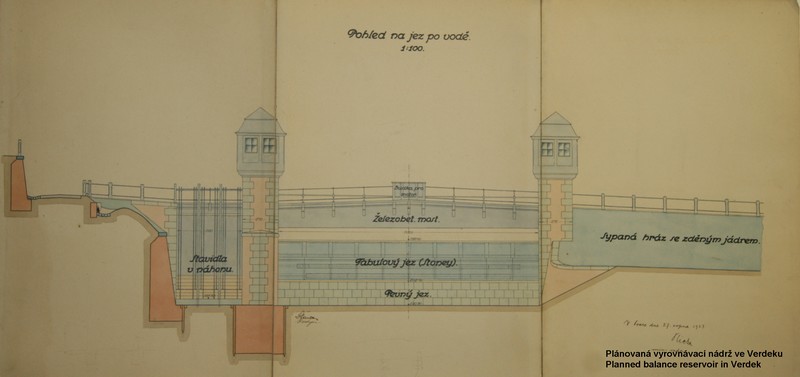
VODNINY VERDEK. Další Limnigraf se naopak nachází pod prehradou v obci Verdek (cache GC26TFH). Toto zarízení je však po nedávné nehode v havarijním stavu a statika objektu je dosti narušená, dnes provizorne zajišteno. Tento limnigraf nebyl vyjma období výstavby prehrady nikdy plne využíván. Jeho puvodní úcel byl urcen pro sledování hladiny Labe pod soustavou prehrad. Soustavou je myšlena dvojice prehrad, která byla v prvopocátcích plánována. Stávající prehrada Les Království mela být prehrada s elektrárnou pracující ve špickách (tudíž zpusobovat velké výkyvy v prutocích reky) a pod ní v obci Verdek se mela nacházet vyrovnávací nádrž - viz. obrázek níže. Casem se od projektu upustilo, protože na Labi byla postavena elektrárna prubežná, využívající bežný prutok reky.
Zdroje:
Bližší informace o prehrade a jejím okolí naleznete v nedávno vydané knížce od pana Karla Martínka Tesnovska prehrada Historie vodniho dila na hornim toku Labe (2009). Kniha je v ceštine a obsahuje velké množství pekných historických fotografií.
Podekování:
Chtel bych podekovat panu Ing. Mokrému a hráznému panu Fejkovi za jejich cas a poskytnutí informací uvedených zde v listingu.
A ted ke CACHE
STAGE 1:
První bod naleznete na následujících souradnicích: N50°27.467´ E015°46.182´.
Zacít mužete na hrázi prehrady, kde lze prípadne zaparkovat Vas dopravní prostredek. Na uvedených souradnicích zacíná cesta, která se pozdeji mení na pešinu a mela by Vás po cca 330 m dovést až ke stage 2.
STAGE 2:
Souradnice, kam je nutné dojít pro další krok k nalezení finálky získáte doplnením získaných indicií ze dvou cache z této série. Po odlovení GC27T4P a GC26TFH získáte dve trojcíslí, která doplníte do následujících souradnic. Bohužel jsem zapomnel, které trojcíslí kam patrí a tak doufám, že si s tím poradíte :-).
N50°27.xxx´ E015°46.yyy ´.
STAGE 3 FINAL-CACHE:
Pro vyluštení šifry z listingu použijte indicie z okolí STAGE 2, znalosti matematiky prvního stupne ZŠ a prípadne dalších pomucek.
Indicie, jsou permanentní znaky v kameni. (Znaky jsou porostlé mechem, prosím nenicte porost a snažte se je precíst a ponechat v takovém stavu v jakém jsou!)
Výsledkem jsou znaky ve tvaru jednociferného císla v rozsahu (2-9). Myslím, že jsem napovedel až moc, interpretace indicii a vylušteni už je jen na Vás.
Výsledkem je jednoznacné umístení cache, s jasným popisem kde hledat. Rešení šifry nejsou souradnice, ale informace, kde se cache nachází. Rozhodl jsem se tak proto, protože v úzkém zalesneném údolí není moc presný GPS signál a nerad bych, aby okolí bylo rozryto hledáním cache. Ze stejného duvodu vyzyvam vsechny lovce, aby se nepokouseli o BF hledání! Krabicka je umistena relativne daleko a jak sami uvidite, prilezitostnych skrysi mezi kameny jsou zde stovky. Cache prosím hledejte pouze po kompletním vyluštení šifry!
Tuto cache bych rád koncipoval jako schránku k shromaždování (umožnující výmenu) predmetu sloužících k jakémukoliv merení. Predstavivost nechám jen na Vás, nechám se prekvapit.
Upozornení:
Pokud budete zacínat cestu od prehrady a pujdete vlastní cestou, pak vezte, že prostor pod prehradou je prostorem zakázaným. Dbejte prosím výstražných tabulek a prípadných zákazu. Samotná cache a veškeré potrebné náležitosti k jejímu odlovení jsou mimo výše uvedené zakázané prostory.
KDE JE CACHE:
(≈/≈)(≈-≈),(≈-≈)(≈/≈),(≈-≈)(≈),(≈/≈+≈)(≈-≈),(≈-≈)(≈/≈),(≈+≈)(≈-≈),
(≈+≈+≈)(≈-≈),,(≈)(≈/≈),(≈/≈+≈)(≈-≈),(≈-≈)(≈+≈-≈),(≈+≈)(≈-≈),(≈/≈)(≈/≈),
(≈/≈)(≈),(≈)(≈/≈),,(≈)(≈+≈-≈),,(≈/≈+≈)((≈+≈)/≈),(≈-≈/≈)((≈+≈)/≈),(≈)(≈-≈),,
(≈)(≈),(≈-≈)(≈+≈-≈),,(≈-≈/≈)((≈+≈)/≈),(≈-≈+≈)(≈), (≈+≈)(≈),(≈)(≈-≈),
(≈/≈+≈)(≈/≈),(≈)(≈-≈),,,
Pro nálezce jsou pripraveny pametní karticky - každý jen jednu!
ENGLISH
NOTE:
1. Signs are not possible to locate during high water levels above first flood level (link).
2. Cache is very often hidden in wrong spot. I ask all cachers to put the cache back exactly to its correct location. If not sure, please contact me.
3. Since autumn 2010 a small local change was done. I have made changes of sign markings, which should not influence consequent calculations.
The cache is not at given coordinates. Given coordinates will bring you to the dam Les Království. It is the final cache of VODNINY series. To solve it you will have to find first following traditional caches.:
cache GC27T4P VODNINY DEBRNÉ
cache GC26TFH VODNINY VERDEK
What is it VODNINY?
Vodniny is a special non-technical term, which was used by my friend in the past. He called VODNINY a self made device for measuring of the water level at our campground. I have borrowed this term for this historical equipment for measuring the water level on the Labe (Elbe) river.
The stone building of "VODNINY" is situated on the left bank of the Labe, river kilometer 316.4 (the length of the river to the national border in Hrensko, according to the new offical kilometer measuring valid from 01.10.2009 it is 1040,999 kilometers), It is situated 294,44 meters above sea level. The building looks like a castle tower, but by its appearance and design thanks to used sandstone evokes nearby dam Les Kralovstvi. Although it was built much earlier, already in 1903 (seven years before start of building of the dam itself). It served as a measuring spot of the Labe flow and was used for recording the data necessary for building the planned dam.
Limnigraph
The correct technical term for this device is LIMNIGRAPH. The device for measuring of the river flow in cubic meters per second based on measuring of the water level at certain place with known riverbed cross-section area.
History a presence
The limnigraph is historical building built at the beginning of the 20th century, it is still in use and is fully functional.The water level is transferred from the float mechanically into recording device and permanently recorded by ink onto graph paper - see picture of the device. In the past after the dam was finished, recorded data of the water level were electrically transferred directly to the dam operator by phone wires. The operator was at every moment aware of current situation about water discharge and from other two stations about the water level in the reservoir itself and the water inflow into the reservoir. The remains of phone lines is possible to see not very far upstream (N50°27.348´ E015°46.266´) - one old pole is still standing here. (During May 2012, the pole was cut down, hopefully you can find its remnants using enclosed coordinates.)
Do not worry that company Povodí Labe s.p. (company who is responsible for the dam operation and maintenance) would not consider any improvements. Modern technical solution has reached even this "deep forest" and the second measuring equipment is working here. The water level is recorded by electronic sensors and is wirelessly on-line transferred to headquarters. You can see actual situation of Labe on-line on www pages of Czech Hydrometeorological Institute .
Flood forecasting service
At STAGE 2 you can see how the water gauging profiles are marked on rivers in the Czech Republic. Flood forecasting service marks each of the flood level by specific color based on the water height in centimeters and corresponding river flow in cubic meter per second.
Flood watch-green-first flood level
Flood warning-yellow-second flood level
Flooding-red-third flood level
Just for your interest see the water level during the last big flood on 9th March 2000. The level is marked by the blue strip. The water level has reached 369 cm and the flow was about 50 times more what you can usually see here or about same amount of water as the avarage of the Labe when leaving the Czech Republic. More information about flood forecasting service see here.
Vicinity of the spot.
Just across the river is so called Los´s quarry, which was used as a stone source for the Labe regulation in Dvur Kralove n.L. The quarry is named after Ing. Antonin Los, whose company was building regulation works.
About 15 meters downstream you can see interesting "cable car". It is not cable car, it is additional equipment for the limnigraph. Using steel cables, regular inspection and measuring of the riverbed and the speed of the river flow is performed. Based on this information, using not very simple calculation is for every known water level counted actual flow of the river. If you would like to find out more about the water level measuring and the river flow look here.
What was not said before
You can locate two similar limnigraph stations in close distance. To finish this cache, you will have to visit both places and to find some information. To find out more see listings for two traditional caches below.
VODNINY DEBRNE. First of them is located in small village (cache GC27T4P) on the right bank, before the Labe reaches the reservoir. This limnigraph has worked long years as a "guard" and has informed the dam operators about the inflow situation into the dam. This station is not working anymore, since the measuring is being flooded during high water levels. The actual water inflow into Les Kralovstvi dam is measured by measuring profile Vestrev about 3 km upstream.
VODNINY VERDEK. Second limnigraph is situated on the other side of the dam, downstream in village Verdek (cache GC26TFH). This station is after recent car crash in bad shape and the structure is quite damaged, but temporarily secured. This limnigraph was never in use except several years during building the dam. Its main purpose was to measure the water level of the Labe river under cascade of two reservoirs, which were originally planned here. The present dam Les Kralovstvi was designed as hydropower generating source working in peaks (causing large water level fluctuation). Downstream, just above village Verdek was planned second balancing reservoir. In meantime the project was abandoned, since the hydropower plant is using continuous flow of the river.
Sources:
Detailed information about the dam and its surroundings you can find in recently published book by Mr. Karel Martinek, Tesnovska prehrada Historie vodniho dila na hornim toku Labe (2009). The book is unfortunately in czech language only, but there is plenty of historical pictures.
Acknowledgments:
I would like to thanks to Mr. Mokry and the power dam operator Mr. Fejk for their time and all information used in this listing.
Information about the cache
STAGE 1:
At following coordinates you will find starting point: N50°27.467´ E015°46.182´.
You can start on the dam body and park your vehicle here. On the coordinates is the beginning of the road, which later becomes a path, it should lead you after approximately 330 meters to the STAGE 2.
STAGE 2:
The STAGE 2 coordinates is the place to where you will solve further action, to obtain them you must finish GC27T4P a GC26TFH. You should find two triple digit numbers to fill up following coordinates. Unfortunately, I have forgot which belongs where, I hope you will manage with this one :-)
N50°27.xxx´ E015°46.yyy ´.
STAGE 3 FINAL-CACHE:
To solve the code from the listing, please use signs from close area of STAGE 2, your grammar school knowledge of mathematics and some additional equipment. Signs are permanent marks carved in stone. (Signs are covered by moss, please do not disturb the growth and try to read and leave them in the same way you will find them!)
The result is a single digit in range (2-9). I think I have already helped you too much, the solution is now only up to you.
When you solve the code, you should clearly know the position of the cache. The solution is not the coordinates, but clear information about location of the cache. I have decided so, there is a very weak GPS signal in deep forested valley. And I do not want to cause destruction of the area by cache searchers. For the same reason I want to appeal to all hunters, not to attempt BF search! The box is located relatively far and as you will see yourself, there is a hundreds of hiding places among stones. Please search the cache after completion of the code!
This cache should be focused for exchange of different items connected with measuring. The imagination is only up to you, surprise me.
Attention:
If you decide to start from the dam and you would like to take your own way, be aware that area downstream the dam is restricted. Please watch out for warning and restriction signs. The cache and everything needed to find the cache is outside above mentioned areas.
WHERE IS THE CACHE:
(≈/≈)(≈-≈),((≈+≈)/≈)(≈-≈),((≈+≈)/≈)(≈+≈-≈),,(≈-≈/≈)((≈+≈)/≈),
(≈)(≈/≈),(≈)(≈),(≈+≈)(≈-≈),(≈-≈)(≈-≈),(≈-≈/≈)((≈+≈)/≈),,
(≈/≈+≈)(≈/≈),(≈+≈/≈)(≈/≈),(≈)(≈-≈),(≈-≈+≈)(≈-≈),(≈)(≈-≈),
(≈-≈)(≈-≈),(≈+≈)(≈/≈),,(≈+≈)(≈/≈),(≈)(≈-≈),(≈-≈)(≈-≈),,
(≈)(≈),(≈/≈+≈)(≈),(≈+≈)(≈),(≈+≈)(≈/≈),,(≈)(≈),(≈-≈+≈)(≈-≈),
(≈-≈)(≈+≈-≈),,(≈-≈/≈)(≈/≈),(≈+≈)(≈-≈),(≈-≈+≈)(≈-≈),(≈)(≈-≈),,,
For finders there are memory cards in the cache - one card per person!
Tato stranka byla jiz zobrazena: