Federsee EarthCache
-
Difficulty:
-

-
Terrain:
-

Size:  (not chosen)
Please note Use of geocaching.com services is subject to the terms and conditions
in our disclaimer.
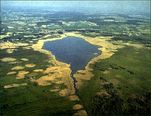
Moorgebiet Federsee Bad Buchau
Geschichte:
Der Federsee entstand in der Mindeleiszeit. Damals schufen die
nördlichen Ausläufer des Alpenrheingletschers einen 150 Meter
tiefen Trog.
Später, nach der letzten Würmeiszeit, kamen dann die Erdmoränen ins
Spiel. Diese schnitten nämlich den Abfluß nach Süden ab und es
entstand ein Eisstausee mit etwa 30km² und bis zu 40 m Tiefe. Als
nun aber das Eis abgeschmolzen war, versiegte der Zufluss und es
kam zum Verlandungsprozess. Das bedeutet dass abgestorbene Pflanzen
und Algen auf den Seegrund sanken und diesen nach und nach
erhöhten. Bis vor etwa 200 Jahrenhatte der See noch eine Fläche von
11 km². Nach und nach wurde der See durch den Menschen Verlandet.
Es gab Seefällungen in den Jahren 1787/88 und 1808/09. Die letzte
auf Befehl König Friedrich von Württemberg. Dies hatte zur Folge,
dass Der See auf etwa 2,5km² und eine Tiefe von 5,4m schrumpfte.
1911 gab es einen weiteren Velandungsprozess der zu einer
Reduzierung der Fläche von numehr 1,5km² führte. Seither wurde
dieser Prozess durch Verbesserung im landwirtschaftlichen
Düngereinsatz und in der Abwassertechnik stark verlangsamt.

Ferderseegebiet:
Im Federseegebiet leben 265 Vogelarten, davon 107 Brutvogelarten.
Auch über 200 Brutpaare Braunkehlchen und 18 Brutpaare der
Rohrweihe bevölkern den See. Über die Bedeutung und die Geschichte
des Moores informieret das Federseemuseum
Das Federseebecken ist bekannt als archäologische Fundlandschaft
mit Siedlungshinterlassenschaften vor allem aus dem Jungneolithikum
und der Bronzezeit bzw. Urnenfelderzeit.
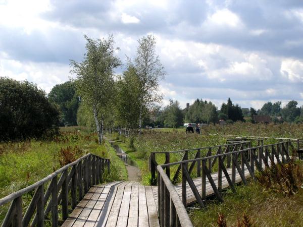
Da durch den Schilf- und Moorgürtel fast nirgends ein direkter
Zugang zum offenen Wasser möglich ist, gibt es in Bad Buchau den
Federseesteg, der vom Parkplatz des Federseemuseums durch das
Schilf bis zum offenen Wasser führt, wo sich eine
Beobachtungsplattform und ein Bootsverleih befinden. Außerdem führt
vom Parkplatz des Federseemuseums ein Steg durch das Banngebiet
Staudacher nach Moosburg. Dem Wasser am nächsten liegt Tiefenbach.
Wenn der nur etwa zwei Meter tiefe Federsee im Winter gefroren ist,
kann man von Tiefenbach zum Federseesteg nach Bad Buchau
laufen.
Aufgaben:
Frage 1: Wann ist der Federsee als eiszeitlicher Schmelzwassersee
entstanden?
Frage 2: Wann war die Mindeleiszeit?
Frage 3: Erkläre, wie ein Niedermoor entsteht. Informiere dich
hierzu an der Infotafel.
Foto: Mach ein Foto von dir und/oder deinem GPS auf dem
Federsteg.
Sendet die Antworten mit "send message" an mich und Ihr könnt
sofort mit Eurem Foto loggen.
Es ist nicht notwendig, auf eine Logerlaubnis zu warten !
English Version:
Federsee is a lake located just north of Bad Buchau in the
region of Upper Swabia in Southern Germany. It is surrounded by
moorland, partially overgrown with reeds. With a size of 33 km²
(8,155 acres), the area is one of the largest, groundwater fed,
connected moorlands in Southern Germany. At its deepest point, Lake
Federsee has a depth of 2 metres (6.5 feet). Federsee translates to
'feather lake' and its shape resembles that of a feather. However,
the origin of its name is locally debated, with one camp defending
the shape theory, and another championing the idea that the amount
of feathers found on the lake's surface gave rise to its name. The
most probable explanation for the origin of the name is, however,
the celtic word "pheder" which means marsh. Therefore the name
refers to the origin of the lake itself and the surrounding
landscape. The lake is encircled by the town of Bad Buchau, and the
villages of Moosburg, Alleshausen, Seekirch, Tiefenbach, and
Oggelshausen.
The lake and its immediate surroundings are a designated Special
Protection Area for the conservation of wild birds. Around 265 bird
species live in the vicinity of the lake, 107 of which are breeding
here. The lake is also populated by 200 breeding pairs of Whinchats
and 18 breeding pairs of Marsh Harriers. Both are endangered
species.
The Lake Federsee area has been declared a Special Protection Area
under the European Union Directive on the Conservation of Wild
Birds and the Habitats Directive. Furthermore, the area is part of
the European ecology network Natura 2000.
The basin of Lake Federsee is famous for its excavations of Stone
Age and Bronze Age artifacts, which are prominently displayed at
the Federsee Museum.
Since the lake is completely surrounded by belts of reed and bogs,
it is impossible to access the lake directly. Therefore, a narrow
wooden boardwalk was constructed. Starting near the parking area at
the Federsee Museum, it leads through the reed belt until open
water is reached. Here one finds an observation platform and boat
rental facility. There are a variety of piers leading to different
parts of the protected area, which otherwise would be inaccessible
by foot.
The village of Tiefenbach is located closest to the water. When
Lake Federsee's surface is frozen during the winter months it is
possible to walk from Tiefenbach to Bad Buchau across the frozen
lake.
Tasks:
Question 1:When has the "Federsee" originated as a glacial melt
water lake?
Question 2: When was the “Mindeleiszeit”?
Question 3: Explain how a low moor originates. Find out at the
information board.
Photo: take a picture of you and/or your the GPS on the
“Federsteg”
Send the answer to the owner via 'send message' and you can log
immediately with your photo.
It's not necessary to wait for an answer or for permission to log
!
Additional Hints
(No hints available.)