Steinbruch Donisse Sehlen EarthCache
Steinbruch Donisse Sehlen
-
Difficulty:
-

-
Terrain:
-
Size:  (other)
Please note Use of geocaching.com services is subject to the terms and conditions
in our disclaimer.

Steinbruch Donisse Sehlen
Quarry Donisse Sehlen
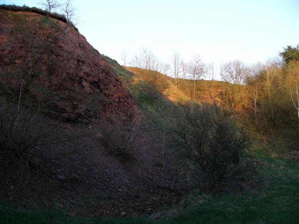
Panorama

German Version:
Steinbruch Donisse Sehlen
Die Donisse liegt östlich des Ortes Sehlen in der Bunstruht und ist eine verschwundene Burg, vermutlich aus dem 9. Jahrhundert. Die Anlage wurde teilweise durch einen Steinbruch zerstört, so daß nur noch Reste des Turmhügels, Wälle und Gräben zu erkennen sind.
Geologisch gehört die Bunstruht zum Burgwald, einer Buntsandsteinplatte, die Halbinselförmig in die älteren Schichten des Rheinischen Schiefergebirges hineinragt. Die Bunstruht und das südlich gelegene Wohratal grenzen den Burgwald vom Kellerwald ab, welcher den östlichsten Ausläufer des Rheinischen Schiefergebirges darstellt.
Die bis zu 421 Meter hohe Buntsandsteinplatte entstand in der Trias vor etwa 220 Millionen Jahren aus Sedimenten des Rheinischen Schiefergebirges, die sich im südlich gelegenen Germanischen Becken ablagerten.
Der Steinbruch ist in einer Bruchzone, die Nord- westlich von Sehlen beginnt und sich bis Süd- westlich von Herbelhausen hinzieht, bereits in dem Zechsteingürtel gelegen, der die Buntsandsteinplatte des Burgwald vom Kellerwald abgrenzt. Diese Bruchzone ist durch Auffaltungen charakterisiert, welche sich auch in diesem Aufschluss deutlich abzeichnen.
Buntsandstein
Der Buntsandstein ist die früheste Abteilung des Trias, welche sich aus Buntsandstein, Muschelkalk und Keuper zusammensetzt. Der Begriff Buntsandstein stammt nicht, wie man vermuten könnte von der bunten Färbung der Gesteine, sondern die verschiedenartigen Sande bilden einen "Verbund". Der Buntsandstein wird unterteilt in den Unteren, Mittleren und Oberen Buntsandstein.
Vor ca. 245 Mill. am Anfang des Erdmittelalters wanderte Deutschland eingebettet im Superkontinent Pangäa durch den Wüstengürtel unserer Erde. Während der Trias war es sehr heiß und trocken. Die Polarregionen waren das ganze Jahr über frostfrei und warm. Das damalige Zechsteinmeer aus dem Perm trocknete langsam aus. In der mitteleuropäischen Senke (germanische Becken), die von Helgoland bis in den Süden von Hessen reichte, lagerte sich periodisch in weitverzweigten Flusssystemen und flachen Binnenseen roter Sand und Ton, abgetragen aus den umliegenden Hochgebieten, ab. Die mächtigen Sanddünen und der vertrockneter Flussschlamm verfestigte sich zum roten Buntsandstein. Der Anteil an Eisen-3-Oxiden gibt dabei dem Sandstein seine typisch rote Farbe
Sandstein ist ein Sedimentgestein (auch „Sedimentit“) aus miteinander verkitteten Sandkörnern, die vorwiegend aus Quarz bestehen. Er entsteht durch die Verkittung (Zementation) von lockerem Sand und hat daher die gleichen Entstehungsbedingungen wie dieser. Er ist klastischen Ursprungs, besteht also aus Trümmern verwitterter und abgetragener Gesteine. Da Quarz ein relativ verwitterungsresistentes Mineral ist, welches außerdem in sehr vielen Gesteinen vorkommt, reichert es sich beim Verwitterungs- und Transportprozess stark an, während andere Mineralkörner zerfallen. Deshalb bestehen die Sandsteine ganz überwiegend aus diesem Mineral. Durch den Auflastdruck der jüngeren, überlagernden Ablagerungen und den natürlichen Chemikalien des Meer- oder Grundwassers und teilweise auch durch Beimischungen im Sandstein selbst kommt es zur Verfestigung (Diagenese) des Sandes. Dieser Prozess läuft unterschiedlich schnell ab und dauert zwischen wenigen Jahrzehnten und mehreren Millionen Jahren.
Zum loggen des Caches lade ein Bild, welches die Erosion der Felswand dokumentiert, zusammen mit deinem Log hoch und beantworte die folgenden Fragen per E-Mail an:
Earthcache.A-Team@gmx.de
Optional würde es uns freuen, wenn man Dich auf dem Bild sehen könnte.
1. Welche Höhe zeigt Dein GPS am angegebenen Punkt ?
2. Wie hoch in etwa ist die Felswand am angegebenen ?
3. Wie breit in etwa ist der Steinbruch in Nord-Süd- Richtung ?
Es darf direkt geloggt werden, bei Problemen melde ich mich. Logs ohne Antworten und Foto
sind ungültig.

English version:
Quarry Donisse Sehlen
The Donisse is a lost castle from the 9.th century laying to the east of the village of Sehlen in the Bunstruht. The complex was partly destroyed by a quarry. Today only parts of the motte, some walls and moats can be found.
Geological the Bunstruht is part of the Burgwald, which is a bunter sandstone plate extended peninsula into the older layers of the Rheinisches Schiefergebirge. Bunstruht and the Wohratal laying to the south are separating the Burgwald from the Kellerwald, the most eastern part of the Rheinisches Schiefergebirge.
This bunter sandstone plate is up to 421 meter high and was build in the age of Trias appr. 220 Mio. years ago by sediments from the Rheinischen Schiefergebirge which were deposit in the Germanischen Becken to it’s south.
The quarry is located in a fracture zone beginning north- west of Sehlen reaching the village of Herbelhausen to the south- west. He already laying inside the Permian limestone zone separating the Burgwald from the Kellerwald. This fracture is characterized by an up folding which is pretty visible in this quarry.
Bunter Sandstone
Bunter Sandstone is the earliest part of the Trias, which is build by the ages of Bunter Sandstone, Lacustrine Limestone and Keuper. The name is not based on the coloured tinct but on the different kinds of sand building a composite. The age of bunter sandstone is divided in lower-, middle- and upper bunter sandstone.
245 Mio. years ago at the beginning of the Mesozoic germany was part of the continent of Pangaea drifting though the earths dessert zone. During Trias it was a very dry and hot climate. Polar regions was frost-free and warm during the whole year and the former Permian limestone ocean slowly desiccated building the middle European basin called “germanisches Becken” reaching from Helgoland to south of Hesse. This basin was periodically filled with red sand and clay from the mountains around by ramified rivers and shallow lakes. The mighty dunes and dried river mud solidify to red coloured bunter sandstone. The typical colour is based on the amount of ferric trioxide.
Sandstone is a sedimentary stone build by cementated grains of sand, mainly silica. He is sedimentary based that means he is build by debris from weathered and worn out stones. Because silica is very resistant material which is also part of many kind of stone, it will be concentrated during the transportation and sedimentation while other minerals decompose. This is the reason for high concentration of silica in sandstone. The sand layers are compacted by the pressure of the younger sediments and finally cemented by the natural chemicals contained in the sea- or ground-water or sometimes admixtures in the sediments itself (diagenesis). This process last varying times between few decades until several million years.
To log this cache you need to upload a photo documenting the erosion of the rockface together with you log. Optional it would be nice to see you on this photo. Further you need to answer the questions by using following e-mail address:
Earthcache.A-Team@gmx.de
1. Which height does your GPS shows at the given coordinates ?
2. What is the approx. height of the rock face at the given coordinates ?
3. What is the approx. width of the quarry in north-south- direction ?
You may log directly, I’ll contact you in case of problems. Logs without photo or answered questions are not valid.
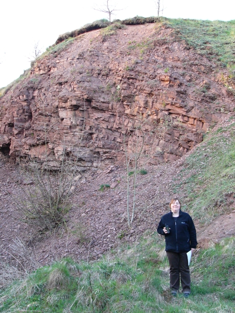
Beispielfoto/ Example picture

|
Besucht doch auch die anderen Das A- Team - (Earth)-Caches:
You may also visit other The A- Team - (Earth)-Caches :
|
GC21P0J Die Wohraquelle/ The Source of the river Wohra (Traditional Cache)
GC22QAP Der Drachenfelsen / The dragons rock
GC22QBW Zechsteinbruch / Permian Limestone quarry "Im Tiefen Tal"
GC25EBC Pikrit- Steinbruch zwischen/ Picrite- quarry between Haina & Battenhausen
GC2KE4B Tonschiefer am Sonderrain/ Clay Slate at the Sonderrain
GC24YDK Naturraum Wohratal/ Wohratal macrochore
GC279YV Steinbruch/ quarry Donisse Sehlen
GC2ARPE Exhelmerstein
Dieser Cache kann auch gut mit GC1C8AC Donisse von Manyx kombiniert werden.
This cache might be also combined with GC1C8AC Donisse by Manyx.
Additional Hints
(No hints available.)