This Earthcache guides you through a nature trail (15 stages, 3 kilometers) counter clockwise around the Montana colorada.
The trail is covered with lapilli and little stones but we managed
to do this trip with a city buggy and our daughter fall asleep
despite of the rocking motion.
You will need about 1,5h for that trip and do not miss the cache
"Lava bomb" (GC1BW5D)!
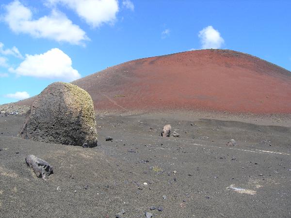
Montana colorada is -like the name suggested- a very colourful volcanic cindercone with black, brown and red colour shades depending on the degree of oxidation of the iron content of the pyroclasts..
Montana colorada was formed during the eruptions from 1730 to 1736.
The bulk of the cone is formed from ash and a’a lava flows, containing sizeable peridotite nodules. These deposits are typical of Hawaiian style eruption (that means: lava is very fluid, often forming shield volcanoes, eruptions are often but not fierce, often a lava lake is build up in the crater throwing hugh fire fontains out of the mid.)
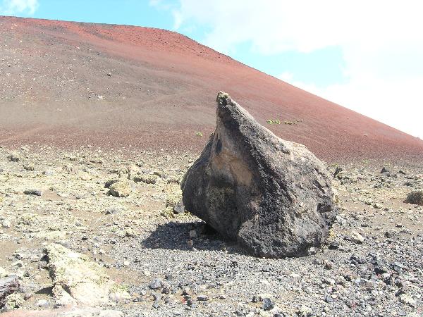
With time the intensity of the eruption appears to have dropped and the lava accumulated in the vent: large meter-sized blocks (lava bombs) are found at distances of greater than 500m from the vent and are the result of a transient explosion of this accumulated lava which was partially solid. This type of eruption reflects a more Strombolian nature (that means: lava is not so fluid, gases escape in irregular intervals, blocks of half solidified lava are expelled from te volcano, the cloud of the eruption is white (containing only a little ash)). From modeling of clast distribution these blocks were ejected at about 70-100 m/s.
The eruption continued to decrease in intensity and a lava pond sat in the crater till the crater spille over and a lava flow ran down the north flanks of Montana Colorada. You can still see it while walking around.
To log this cache as a found you have to send me the awnsers for the following tasks via e-mail
a) What is the name of the small size pyroclasts (in english)?
b) Which group of plants is the pioneer plant after an eruption?
c) At waypoint "tear" you will find a lava bomb in the shape of a tear drop. Assuming that this one was spilled out by the Volcano which formed Montana Colorada and that it is still in its original place, estimate its flight distance from its genesis point in the crater over the ground (that means estimate its distance from the volcano not the length of its parable flight).
d) Which Montana was chosen on the infoboard as an example for the influence of winds during an eruption? Montana ...
e) Estimate the width of the overflow at the north flank on the crater rim (you got a good look of it between board number 10 and 11). Tell me the colour of this flow and if the pioneer plant grow here already or not.
f) How long is the tectonic fissure underlying the eruptions from 1730 to 1736?
g) Edit: 2.8.2021Upload a picture of you or your GPSr at a recognisable spot with the Montana Colorada in the background (for example at the lava bomb)(re-allowed by GC since June 2019.)
Logs without the mail will be deleted without comment. Do not wait for log-permission, just log your found directly after sending the mail; we will contact you if there is something wrong.