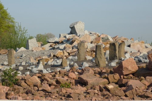
The site / Die Lokation
 You will be led to one of the most controversially discussed sites
of the Geo-Park "Bergstraße-Odenwald"-projects. A beautifully
crafted andmaintained area shows you the different zones of soil,
stone and vegetation that can be found here between the Upper Rhine
Valley and the Odenwald. At the site-location, a detailed signboard
gives you background information on the geological aspects. Besides
that, from my personal point of view, it shows an ethical aspect of
mankind's handling of nature, by placing the areal inside a large
traffic roundabout.
You will be led to one of the most controversially discussed sites
of the Geo-Park "Bergstraße-Odenwald"-projects. A beautifully
crafted andmaintained area shows you the different zones of soil,
stone and vegetation that can be found here between the Upper Rhine
Valley and the Odenwald. At the site-location, a detailed signboard
gives you background information on the geological aspects. Besides
that, from my personal point of view, it shows an ethical aspect of
mankind's handling of nature, by placing the areal inside a large
traffic roundabout.
 Dieser Earthcache führt Euch zu einer der meistdiskutierten
Installation des Geoparks "Bergstraße-Odenwald". Eine wunderschön
gestaltete und gepflegte Anlage zeigt die vier unterschiedlichen
Boden- und Gesteinsbereiche zwischen dem Oberen Rheingraben und dem
Odenwald. Eine vor Ort installierte Informationstafel gibt euch
detaillierte Informationen zu diesem Geopunkt. Der Spannungspunkt
dieser Lokation ist die Platzierung - das wunderschöne Fleckchen
liegt mitten auf einem Verkehrkreisel.
Dieser Earthcache führt Euch zu einer der meistdiskutierten
Installation des Geoparks "Bergstraße-Odenwald". Eine wunderschön
gestaltete und gepflegte Anlage zeigt die vier unterschiedlichen
Boden- und Gesteinsbereiche zwischen dem Oberen Rheingraben und dem
Odenwald. Eine vor Ort installierte Informationstafel gibt euch
detaillierte Informationen zu diesem Geopunkt. Der Spannungspunkt
dieser Lokation ist die Platzierung - das wunderschöne Fleckchen
liegt mitten auf einem Verkehrkreisel.
The Geo-Park site structure / Aufteilung des Geländes
The areal has been divided into four parts, that show you the
different areas of soil. The attached sketch gives you an overview
on the layout of the parts:
Die Anlage ist in vier Bereiche aufgeteilt, die die geologischen
Eigenheiten der Region zeigen. Der folgende Grundriss gibt einen
Überblick:
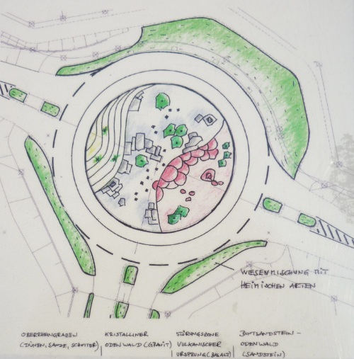
The Upper Rhine Valley / Oberrheingraben
This areal has been formed in millions of years by the flow of the
river rhine. The waters have carved a huge bed into the ground,
today the soil is mainly consisting of sand. You will find many
sand-dunes in this area, so the "Upper Rhine Valley"-part of the
site shows you a sanddune with typical vegatation. During the
ice-age sand (silicium-dioxide) has been piled to dunes. The dunes
in this region are mostly formed by loess (loam) which is a
sediment formed by the accumulation of wind-blown silt and lesser
and variable amounts of sand and clay and brash.
In mehreren Millionen Jahren formte der Fluss Rhein durch Erosion
diesen Bereich. Das Wasser grub ein riesiges Flussbett in den
Untergrund, der heute hauptsächlich aus Sand besteht. Der regionale
Bereich des Oberrheingrabens ist charakterisiert durch Sanddünen -
eine solche zeigt auch der zugehörige Bereich der
Earthcache-Anlage, mit typischer Ried-Vegetation.
The Cristalline Odenwald / Kristalliner Odenwald
This area ist mainly characterized by over 300 million year old
rocks. They originate from the roots of a long eroded mountain
range. Granite has a medium to coarse suface made of different
mineral grains, that are distinguishable even by sight. It's color
can range from light rose upto black.
Dieser hauptsächlich durch Granitgestein charakterisierte regionale
Bereich entstand aus einer fast vollständig erodierten Bergkette.
Die Felsen des Bereich sind über 300 Millionen Jahre alt! Die
Oberfläche des Granits ist sehr rauh und besteht aus vielen
einzelnen Bestandteilen, die durch unterschiedliche Farbgebung
sichtbar sind. Je nach Zusammensetzung kann Granit farblich
zwischen rosa über dunkelgrau bis schwarz changieren, je nach
mineralischer Zusammensetzung.
The Vulcanic Fault Zone / Vulkanische Störungszone
In the eastern area of the Odenwald, a vulcanic fault zone is
located. As the name implies, it originates from vulcanic actvities
in the area. It is geologically characterized by craters filled
with basalt. Basalt is a common extrusive volcanic rock. It is
usually grey to black and fine-grained due to rapid cooling of lava
at the surface of a planet. It may be porphyritic containing larger
crystals in a fine matrix, or vesicular, or frothy scoria.
Im östlichen Teil des Odenwalds gibt es eine geologische
Besonderheit: eine vulkanische Störungszone. Durch vulkanische
Aktivitäten entstandener Basalt charakterisiert den Bereich
geologisch. Der Basalt entstand aus flüssiger Lava, seine
Oberfläche ist feinkörnig und grau bis schwarz.
The Red Sandstone-Odenwald / Rot-Sandstein Odenwald
The most eastern part of the Odenwald is the youngest part, in
geological terms. It consists of red sandstone piles. Sandstone is
a sedimentary rock composed mainly of sand-sized minerals or rock
grains. Most sandstone is composed of quartz and/or feldspar
because these are the most common minerals in the Earth's
crust.
Der aus geologischer Sicht "jüngste" regionale Teil liegt im
östlichen Odenwald. Er besteht hauptsächlich aus Sandstein, einem
Sediment-Gestein, das hauptsächlich aus Sandkorn-großen Mineral-
oder Felskörnern besteht. Sandstein besteht weitgehend aus Quartz
und Feldspat, den am häufigsten auftretenden Mineralen der
Erden.
The Quest / Eure Aufgabe
You can find the answers to the questions on site on the
informational sign. Please prove your visit to this site by
sending the answers to my GC.com account, then you may log, I
will contact you in case of problems. Logs without an answer-mail
will be deleted. If you like, you may upload a logfoto, this is a
voluntary rule.
- Which geological material with local relevance was created 500
Mio years ago?
- Please complete "alte ........ Schiefer".
- Which of the stones shown has the highest density?
- What is the weight of all the stones that were used to craft
the area?
I hope, that you like this site as I do and comment your
experience here in your logs.
Ermittelt die Antworten zu den folgenden Fragen vor Ort mit Hilfe
der Informationstafel. Wenn Ihr möchtet, ladet bitte ein Logfoto
hoch - wir freuen uns darüber! Schickt bitte vor dem Loggen Eure
Antworten an meinen GC-Account und loggt direkt online, ich
melde mich, wenn es Probleme geben sollte. Logs ohne Antwortmail
werden direkt gelöscht.
- Welches regional relevante Gestein entstand vor über 500
Millionen Jahren?
- Bitte vervollständigt "alte ........ Schiefer".
- Welches der gezeigten Gesteine hat die höchste Dichte?
- Wieviel wiegen die Steine, die zur Gestaltung der Anlage
genutzt wurden?
