Holsteinische Schweiz - Pariner Berg (Earthcache) EarthCache
This cache has been locked, but it is available for viewing.
Holsteinische Schweiz - Pariner Berg (Earthcache)
-
Difficulty:
-

-
Terrain:
-
Size:  (not chosen)
Please note Use of geocaching.com services is subject to the terms and conditions
in our disclaimer.

Holsteinische Schweiz
Als Holsteinische Schweiz wird das östliche Hügelland Schleswig-Holsteins bezeichnet, eine Region, die in der letzten Eiszeit geformt wurde.
Die geografisch nicht genau begrenzte Kulturlandschaft beinhaltet unter anderem den Naturpark Holsteinische Schweiz und zählt zu den wichtigsten Tourismusregionen in Norddeutschland.
Pariner Berg
Der Pariner Berg ist eine 70,05 m hohe Erhebung in Bad Schwartau (Kreis Ostholstein in Schleswig-Holstein) im Ortsteil Groß Parin. Auf ihm steht eine Bismarcksäule.
Geologisch handelt es sich um eine - für die Holsteinische Schweiz typische - eiszeitliche Endmoräne des Baltischen Landrückens. Der Pariner Berg stellt die nördliche Begrenzung des Lübecker Beckens dar. Im Osten werden die Ausläufer der den Pariner Berg bildenden Endmoräne durch das Urstromtal der Schwartau begrenzt.
Aufgrund seiner exponierten Lage war der Pariner Berg Standort einer Windmühle - in der sich während des Zweiten Weltkrieges das Zwangsarbeiterlager Pariner Berg befan. Das Gebäude der letzten Windmühle wird heute als Wohnhaus genutzt.
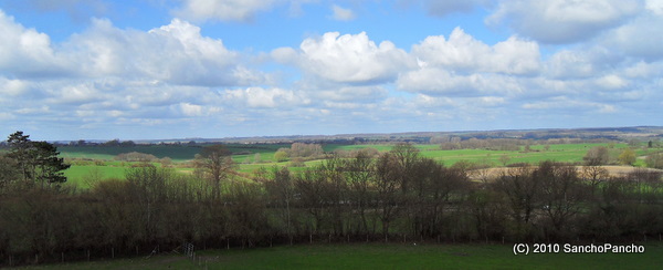
Die Bismarcksäule (Pariner Berg) (Erbaut 1901/1902, Höhe 12,80 m) gewährt einen sehr schönen Ausblick auf die Umgebung bis Lübeck, Neustadt, die Lübecker Bucht und die Hügellandschaft der Holsteinischen Schweiz.
Endmoräne
Eine Endmoräne oder Stirnmoräne ist eine wallartige Aufschüttung (Moräne) von Gesteinsmaterial am Ende eines Gletschers. Eine Endmoräne kennzeichnet die Linie des oder eines maximalen Gletschervorstoßes oder eines Gletscherstillstandes. Sie ist Bestandteil der Glazialen Serie.
Logbedingungen:
1. Beschreibt mir in kurzen Sätzen die Entstehung einer Endmoräne.
2. Ermittelt mit Eurem GPS die Höhe, gemessen auf der Bismarksäule und schickt sie mit per Email.
Wenn alles ok ist, dann schicke ich Euch die Logfreigabe. Ein Foto von Euch auf der Bismarksäule wäre schön.
Viel Spaß wünscht
SanchoPancho 

Holstein Switzerland
Geography
Holstein Switzerland lies in eastern Schleswig-Holstein. This picturesque region in the historical county of Wagrien has no precise political or geographic boundaries. Most of the area falls within the districts of Ostholstein and Plön, roughly between the cities of Lübeck and Kiel and extends as far north as the Baltic coast. Its major towns include Bad Malente-Gremsmühlen, Lütjenburg, Oldenburg in Holstein, Preetz and the old Residenz seats of Eutin and Plön.
The charm of this region is its ever-changing landscape of the Young Drift moraines of the Schleswig-Holstein Uplands which were formed during the last ice age. Small woods alternate rapidly with hedged, arable fields and the terrain is characterised by its many lakes nestling amonsgt low hills. Amongst the more well-known lakes are the Großer Plöner See, the Dieksee and the Kellersee. Rivers and water meadows abound, such as the Schwentine, which flows into Kiel Fjord or the Kossau, which discharges into the Großer Binnensee. The highest elevation is the Bungsberg near Schönwalde. With the only ski lift in Schleswig-Holstein and a height of 168 metres (551 ft) above NN it is also the highest 'mountain' in the state.
Pariner Berg, Terminal moraine
A terminal moraine, also called end moraine, is a moraine that forms at the end of the glacier called the snout.
Terminal moraines mark the maximum advance of the glacier. An end moraine is at the present boundary of the glacier.
Quelle: wiki
To log the cache, the following tasks have to be met:
1. Describe me by mail in short sentences, the emergence of a terminal moraine.
2. Call me by mail the amount that you have established with your GPS.
If everything is right, I will send you the log permission. A photo at the top of the tower would be nice.
Have fun !
sanchopancho
Additional Hints
(No hints available.)