Earthcache Teufelsschlucht
English below
Die Teufelsschlucht befindet sich am Ostrand des Ferschweiler Plateus im Naturpark Südeifel in der Nähe von Irrel.
Sie entstand gegen Ende der letzten Eiszeit, vor ca. 10.000 Jahren infolge eines Felssturzes bzw. einer Serie von Felsstürzen.
Maßgeblich für dieses Ereignis war die geologische Situation zum einen, die klimatische Situation zum anderen.
Die stark geklüfteten, mehr oder weniger porösen Gesteinsschichten des sogenannten Luxemburger Sandsteins (geologisch in den unteren Jura, das Lias einzuordnen) lagern auf den zur Wasserundurchlässigkeit neigenden Schichten des Keuper. Somit ergibt sich bei fortschreitender Verwitterung eine instabile Lagerung durch Unterschneidung der Sandsteinbasis. Gegen Ende der letzten Eiszeit erreichte diese Unterschneidung in Kombination mit ausgedehnter Frostsprengung wohl ein Maximum, das besagte Felsstürze zur Folge hatte.
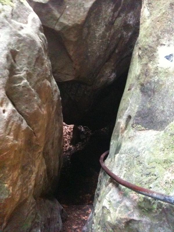
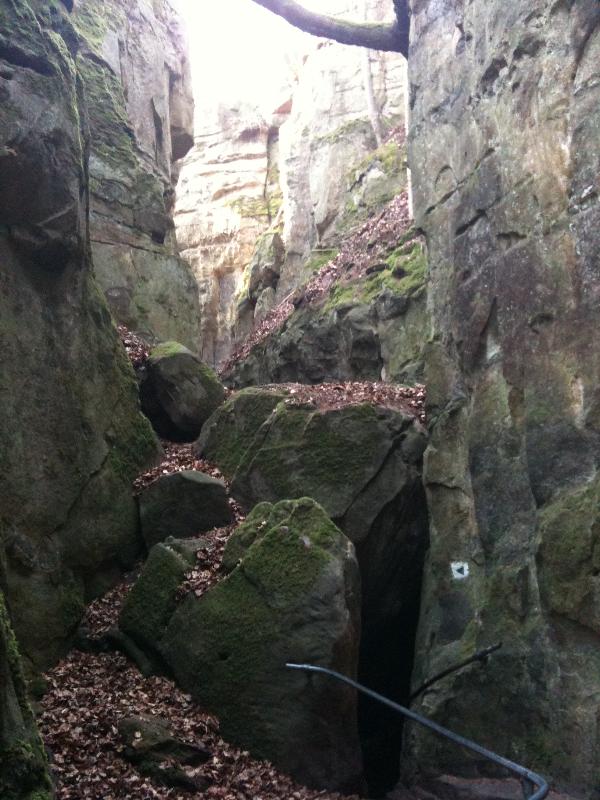
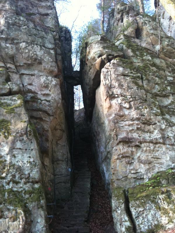
Heute zeugen zahlreiche Felsblöcke an den Hängen des Ferschweiler Plateaus von den Massenbewegungen dieser Zeit. Die Teufelsschlucht ist als Felsspalte mit ca. 1 bis 5 m Breite als direkte Folge der Felssturzereignisse anzusehen.
Mit einer bizarren Felsenlandschaft mit steilen Felswänden, engen Schluchten und Spalten ist die Teufelsschlucht ein ideales Ausflugsziel und Startpunkt für weitere Wanderungen in die Umgebung.
Quelle: wikipedia
Parken kann man bei der Koordinate
N49°50.678
E006°25.964
Vom Parkplatz folgt dem ausgeschildertem Weg zum Besucherzentrum. Unterwegs könnt ihr noch einen Stopp beim Earth Cache „Erdzeitschnecke (GC15WA4)“ machen. Dieser liegt direkt auf dem Weg zum Besucherzentrum und bietet jede Menge Informationen über das Gestein der Erde.
Das Besucherzentrum findet ihr bei:
N49°50.807
E006°26.129
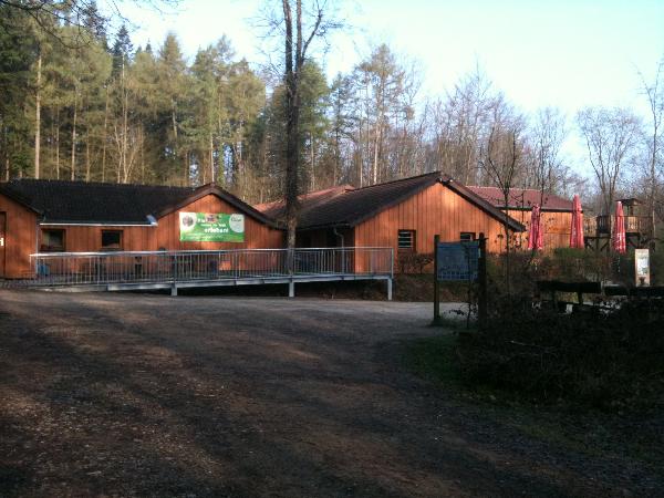
Die Öffnungszeiten des Besucherzentrums sind:
Freitag, 1. Januar bis Sonntag 3. Januar täglich von 11 bis 18 Uhr
Sa, 27. März bis einschließlich Mo, 1. Nobember 2010 täglich von 11 bis 18 Uhr
Hier kann man in der Imkerei Honig kaufen, Informationen über die Felslandschaft sammeln und im Restaurant das ein oder andere Getränk genießen!
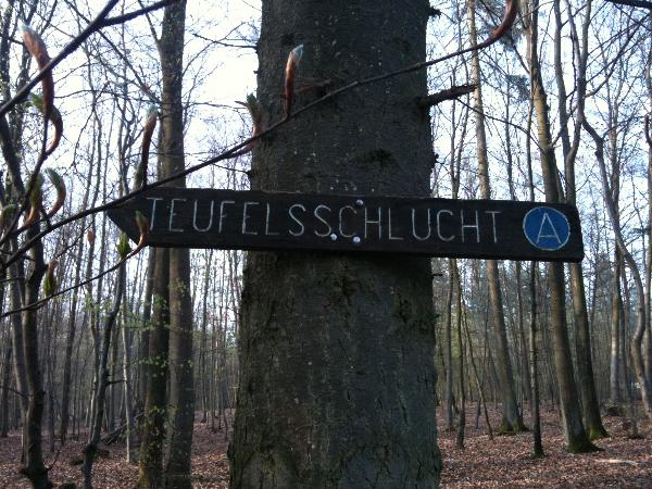
Nun geht ca. 500m zur Teufelsschlucht.
Dort beantwortet folgende Fragen deren Antworten in der Nähe der Koordinate zu finden sind.
N49°50.733
E006°26.409
1. Wann kam es zu Gewaltigen Feslrutschungen und zur welchen Zeit ist dies Geschehen? (Abweichend von Angabe weiter oben im Text)
2. Wie tief ist die Felsspalte?
3. Wie hat sich der Sandstein gebildet.
4. Wie weit ist laut Schild Echternacherbrück von der Teufelsschlucht entfernt.
Steigt nun hinunter in die Schlucht wo Ihr ein Foto von Euch und Eurem GPS vor einer schönen Stelle machen könnt, lasst euch hierfür was besonders einfallen!!
Alternativ schlage Ich das Ende der Schlucht vor(N49°50769, E006°26.433). Dort kann man auch wunderbar Fotos machen.

Um diesen Cache zu loggen müsst Ihr die Fragen richtig beantworten. Ihr dürft direkt loggen, ich melde mich bei Fehlern! Ein Foto hochzuladen ist laut Geocaching nicht mehr notwendig wäre aber trotzdem schön!
Bitte bleibt immer auf den Wegen und nicht Klettern!! Absturz und Verletzungsgefahr!!
Wir wünschen Euch eine schöne Wanderung und viele schöne Momente in der Teufelsschlucht!
Weitere Informationen erhaltet auch unter der Homepage www.teufelsschlucht.de.
Kennyone10
Team The Next Topcacher
________________________________________________________________________________________________________________
English translation by Maacher! Thank you very much!!
Earthcache Teufelsschlucht
The devil's gorge is located at the East edge of the Ferschweiler plateau in the nature reserve Südeifel close to Irrel.
It formed by the end of the last Ice Age, approx. 10,000 years ago as a result of a rock fall or a series of such. Both the geological and the climatic situation was decisive for the creation process. The strongly fissured and quite porous rock layers of the so-called Luxemburg sandstone (lower Jurassic period - Lias) base on the water impermeable Keuper layers. Therefore an unstable foundation results with progressive decomposition by untercutting of the sandstone base. By the end of the last Ice Age this untercutting probably reached a maximum in combination with vast breaks due to action of frost, causing the mentioned rock falls.
Today numerous boulders remain on the slopes of the Ferschweiler plateau being silent witnesses of the mass movements of this time.
The devil's gorge is a rock fissure of approx. 1-to 5-m width as a direct result of the rock fall events. With a weird rock scenery made of precipitous cliff faces, narrow fissures and columns the devil's gorge is an ideal destination and starting point for other hikes in the surroundings.
Source: Own translation from german Wikipedia
You can park at N49°50.678 E006°25.964
From the parking lot follow the marked trail to the visitor center. On the way you may stop for the Earth cache „Erdzeitschnecke (Earth Age Snail) (GC15WA4)“. It lies on the way to the visitor center and offers valuable information about the Earth Ages.
Find the visitor center at: N49°50.807 E006°26.129
The opening times of the visitor center are:
Friday, 1 January till Sunday 3 January daily from 11 to 18 o'clock Saturday, 27. March till Mo, 1st Nobember 2010 daily at 11 to 18 o'clock
Here you can buy honey, collect information about the rock landscape and rest for a while at the restaurant!
Now walk approx. 500m to the devil gorge.
Answer the following questions close to N49°50.733 E006°26.409
1. When did enormous rockslide occur (time and age)? (Notice that this deviates from above text) 2. How deep is the rock fissure (gorge)?
3. How did the sandstone form?
4. How far away is Echternacherbrück as written on the sign?
Now descend into the gorge and take a photo of you and your GPS in front a beautiful place if you like!
Alternatively I sugguest to pass to the other end of the gulch (N49°50769, E006°26.433), as there you will find some nice places to take some pictures.
To log this cache you must answer the questions properly. Then you will receive a log approval! A picture is NOT obligatory, but it would be nice.
Please don´t climb and always stay on the trail! Risk of falling!!
We wish you a nice hike and many nice moments in the devil's gorge!
Kennyone10 Team The Next Topcacher
Further information can also be found on the homepage: www.teufelsschlucht.de.