Nottingham Castle Rock is an enduring geological feature in the heart of Nottingham City.
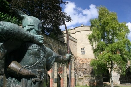
It also has a place in both history and folklore, famous for Robin Hood, The Sheriff of Nottingham and the Oldest Inn in England, The Trip to Jerusalem is the place where crusaders are suggested to have started and finished their journey to the Holy Land.
Castle Roock is an area that is scheduled as an ancient monument so please respect the surroundings. This earthcache has been designed with this in mind, and the cacher is expected to keep to the public footpaths and behind the railings to carry out the tasks. .
This Earthcache takes you even further back in time, to find out how this landmark rock was formed.
THE TASKS
GO TO
N52 57 042 W001 09 221
QUESTION 1
HOW MANY MILES IS THE FOOTPATH THAT STARTS FROM HERE
(YOU MAY WANT TO NOTE THE ELEVATION READING ON YOUR GPS HERE)
GO TO
N52 56 992 W001 09 157
NOTE THIS INFORMATION BOARD IS PROVIDED BY THE BRITISH GEOLOGICAL SOCIETY
GO TO
N52 56 931 W001 09 276
QUESTION 2
USE YOUR GPS HERE TO FIND OUT YOUR ELEVATION AND THEN TELL ME WHAT IS THE HEIGHT OF THE CLIFFS, (YOU CAN USE THE FIRST READING AT THE CASTLE GATES MINUS THIS ONE TO GET THE ANSWER)
QUESTION 3
ALTHOUGH A SOFT STONE CASTLE ROCK SANDSTONE IS STRONG - WHY DO YOU THINK THIS IS? THE ANSWER CAN BE FOUND BY EXAMINING THE LENTON ROAD SECTION, WHAT IS THE DISTANCE BETWEEN THE JOINS IN THE ROCKS HERE
QUESTION 4
EXAMINE THE LAYERING OF THE SANDSTONE AS YOU WALK AROUND THE ROCK AND DESCRIBE WHAT YOU SEE THAT MAKES UP THE STONE.
THERE ARE A NUMBER OF OBVIOUS PHOTO OPPORTUNITIES ON THIS ROUTE AND IT WOULD HELP ME TO VALIDATE YOUR VISIT HERE IF YOU POST A UNIQUE PHOTO INCORPORATING YOUR GPSR READING WHILST ON YOUR WALK AROUND THE SITE. (ALTHOUGH THIS IS NOT A PRE-REQUISITE OF COMPLETING YOUR TASKS)
Your modern day ‘crusade’ will start at the Nottingham Castle gates and then continue down the nearby paths and walkways, treading in the footsteps of those Ancient Crusaders. You will travel down the hill and pass The Trip to Jerusalem pub, walk through the old Brewhouse Yard (if open) and to the foot of the cliffs upon which the castle stands. Then into the Park and turn right up Lenton Road, taking you behind the castle and back up the hill to your starting point.
This is a relatively short circular walk along wheelchair friendly terrain, with slight gradients. This Earthcache should take about 30 to 45 minutes to complete.
The cacher will have to complete 4 tasks whilst on this walk, noting the height of the cliffs, the make-up of the Sandstone and explain your thoughts as to why this stone lis strong enough to build upon.
Although there are no longer bands of Merrie Men in the caves, you may be tempted to stray along the way, either to log the traditional caches in the area or at the nearby hostelries!
THE INTRODUCTION
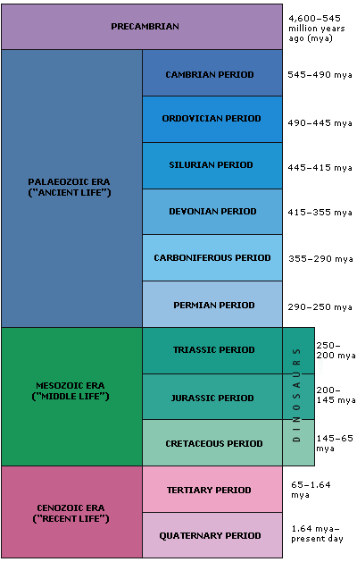
About 248 to 199 million years ago Nottingham (and in fact the United Kingdom) was part of one huge supercontinent. This time is referred to as The Triassic Period. The middle of this massive land mass was so far from the oceans, it was like a desert. The whole world was generally pretty warm and there was no ice at the North and South poles.
Although Sandstone can form during any era Nottingham's sandstone has been identified as being from the Triassic Period. The table below shows where this period falls, I wonder what kind of dinosaurs roamed the Nottingham desert then!!
The Earth’s crust is made up of rocks, different kinds of rock. All rocks are made up of minerals. Some rocks are hard and solid, such as granite, others are soft, such as sandstone.
The Earth’s crust around Nottinghamshire is mainly sandstone. Sandstone is a soft rock that is generally made up of sand mud and pebbles.
Sandstone is classified as a sedimentary rock (a rock made up from sediment), it is composed of fieldspar and quartz. It can vary in colour from white to red, (including grey and yellow) . Sedimentary rocks have layers or strata.
Sandstone is formed from cemented grains that may be fragments of a pre-existing rock, or else just crystals. The cements binding these grains together are typically calcite, clays and silica. Grain sizes in sands are in the range of 0.1mm to 2mm. Rocks with smaller grainsizes include silts and clays. Rocks with larger grainsizes include both breccias and conglomerates. The principle mechanism for the formation of sandstone is by the sedimentation of grains out of a fluid, such as a river, lake or sea.
NOTTINGHAM & CASTLE ROCK
There are a number of sandstone features around the County of Nottinghamshire, but this Earthcache site is the most notable.
Sandstone, because of its’ make up (soft texture) is subject to erosion, and the cliffs at Castle Rock were formed by erosion from the course of the River Leen and the flooding of the River Trent.
The cliffs around Castle Rock are now fenced off, but the caves carved into the sandstone can still be seen from relatively close quarters. Nottingham City sits upon a soft sandstone ridge. Nottingham was once known as ‘TIGGUO COBAUC’ which means ‘Place of Caves’
Due to the sandstone being soft and easy to cut, a number of ‘caves’ were dug out of the rock face, these were used both as houses and store rooms. Caves can be found around the foot of the Castle Rock and at other places in the City Centre, some of these caves are thought to date back to prehistoric times, all appear to be man-made. The caves have been used as warehouses, dwellings, party places and hiding places for nonconformists to name but a few.
The original Saxon settlement in Nottingham was located on a sandstone plateau. This area is now known as The Lace Market. The first record of a castle being built in Nottingham and the settlement relocating to the area surrounding the castle is dated just after 1066, when the Normans built a military stronghold at the top of the cliffs now known as Castle Rock.
In the 13th Century the original castle was ‘upgraded’ with a stone building being built. It remained an important Royal residence for hundreds of years. The current building is not a castle, more a palace which was built in the 1670’s and then refurbished in the 1870’s. The enclosed grounds were once part of the original castles and fragments of the original castles can still be seen.
The sandstone is said to be soft and can be cut by hand tool, take a closer look at the formation of the exposed rocks and note how tightly packed it is. The formation means that the stone is strong and it has allowed for extensive building work to be carried out all over the City above the caves and tunnels with little or no problems of subsidence. There are a number of sand mine shafts still in being that run under the City centre area. This is testament to how compact and strong the sandstone is.
Whilst enjoying the history of this area, please take some time to appreciate how the landscape was formed and what lies beneath the City buildings. The Castle Rock allows you to see close up the rock formation and how our ancestors used it to their own ends. If you want to explore the caves beneath the City of Nottingham further then you may wish to visit the Broadmarsh Centre where you will have to pay an entrance fee to find out more.
The below map shows the geology of the general area around Castle Rock. It also shows the original course of the River Leen prior to it being canalised and directed into the River Trent. The area marked ‘The Park’ is part of the Lenton area of Nottingham and you walk through The Park back up the hill to make this a circular walk.
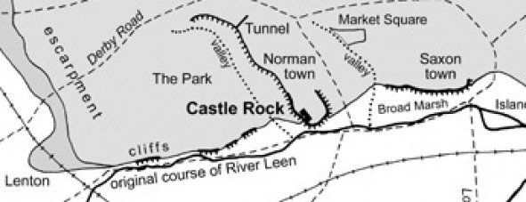
You can also walk through The Park to access another cache of mine, it is shown on the map as 'TUNNEL'. this also allows a very close examination of the sandstone and illustrates how Nottingham was built on a base of sand.

I hope that you enjoy your visit to Nottingham Castle Rock and that you now understand how the sandstone that Nottingham is built on was formed and how the landscape has changed over time.
Please upload any photographs directly onto the cache page BUT e-mail may your answers to the 4 questions. Please have the courtesy to wait for my acknowledgement before posting a 'find'. I will remove any logs from people that have not answered the questions correctly or that have not visited this site, thanks and Happy Caching. CONGRATULATIONS AND THANKS GO TO MUDSHAKE AS FTF AND 'SPOT THE DELIBERATE MISTAKE' WINNER!!