Die als Bayerischer Pfahl bezeichnete auffällige Serie von Felsstrukturen gilt als eine der markantesten geologischen Störungszonen Mitteleuropas. Durch tektonische Bewegungen an der Störung wurden Gesteine bei hohen Temperaturen, teils noch während der Erstarrung, plastisch deformiert und zu Myloniten umgewandelt.
Mylonite entstehen an tektonischen Störungszonen durch scherende Bewegung zweier aneinander vorbeigleitender Gesteinskörper. Das wesentliche Merkmal von Myloniten ist die duktile Verformung des Gesteins bei hohen Temperaturen.
Vor etwa 250 Millionen Jahren rissen entlang des Pfahls, der sich in fast schnurgerader Richtung 150 Kilometer von der Oberpfalz im Nordwesten bis in die Nähe von Linz (Österreich) im Südosten zieht, Fiederspalten auf, in deren Hohlräumen ca. 300 °C heißes Thermalwasser zirkulierte, und dabei vor allem Quarz ablagerte.
Der weiß schimmernde Pfahlquarz besteht aus bis zu 98% Kieselsäure, gelbliche bis rötliche oder graue Verfärbungen werden durch Eisenverbindungen und Verunreinigungen verursacht.
Quarz ist die auf der Erdoberfläche stabile Form des Siliciumdioxids und das zweit häufigste Mineral der Erdkruste nach den Feldspaten.
Quarz gehört mit einer Mohshärte von 7 zu den harten Mineralen und dient als Bezugsquelle auf der bis 10 (Diamant) reichenden Skala nach Friedrich Mohs.
Quarz besitzt keine Spaltbarkeit, bricht muschelig wie Glas und zeigt einen fettigen Glanz auf den Bruchstellen.
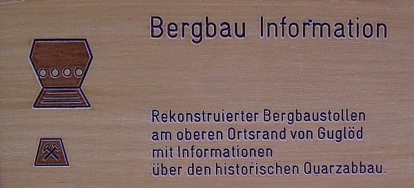
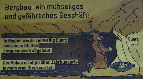
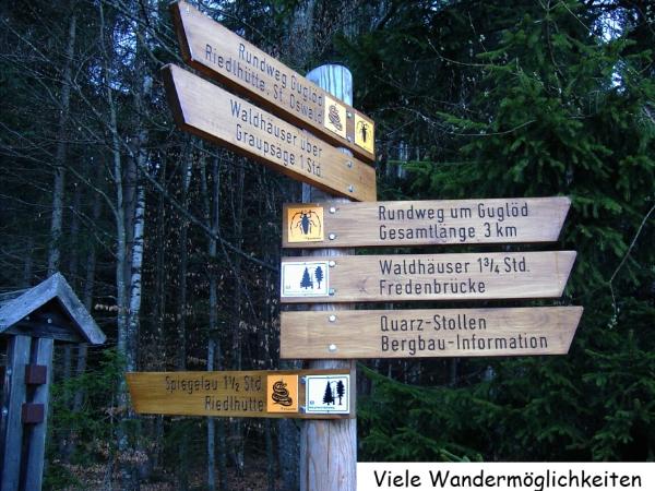
Hier, an dieser historischen Stelle nahe der Ortschaft Guglöd bei Spiegelau, die erstmals 1673 unter Franz Poschinger urkundlich belegt ist, wurde vermutlich schon seit der Entstehung der Glashütten in Riedlhütte (1450) und Guglöd (1638) Quarz abgebaut. Anfänglich, so wird vermutet, wurde eine aus dem Waldboden ragende Quarzlinse abgetragen. Später wurde dann zunächst im Tagebau und dann in einem Stollen im bergmännischen Abbau bis zum Jahr 1873 gearbeitet.
Als Bezugsquelle für obige Beschreibung diente ausschließlich das Internet (Wikipedia usw.).


Um den Cache loggen zu dürfen, beantworte folgende Fragen und schicke sie mir per (GC - Email) zu.
Alle Antworten auf die Fragen findest Du vor Ort!
1). Wie heißt die Chemische Zusammensetzung von Quarz und welche 3 Teile beinhaltet sie?
2). Wo haben Quarzschürfer und Quarzsammler in ca. 420 Jahren, von 1450 bis 1877, für die Glashütten Riedlhütte, Guglöd und Neuriedlhütte Quarz gebrochen und gesammelt?
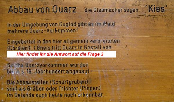
3). Eingebettet in den hier allgemein verbreiteten (Cordierit-) Gneis tritt Quarz in welcher Gestalt auf?
4). Von wann bis wann war die Familie Roscher Besitzer der Riedl-Hütte?
5). Wie hoch war der Quarzbedarf der Glasfabrik in Riedlhütte im Jahre 1834?
6). Wie viele Steinstufen musstest Du kurz vor dem Ziel herunter steigen?
Bitte sofort (ohne auf meine Bestätigung zu warten) loggen. Es wäre schön, wenn Du ein Bild von Dir und/oder deinem GPSr vor dem Stolleneingang machst und es in den Log stellst.
Logs, welche die Bedingungen nicht erfüllen, sind hier unerwünscht!
Logeinträge ohne zeitnaher Zusendung der Antworten fliegen künftig kommentarlos raus!!!
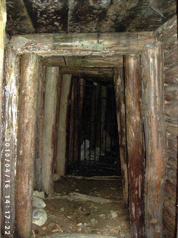
Nehmt Euch eventuell eine starke Taschenlampe mit, da der Zutritt zum Stollen verboten ist und Ihr damit doch ein Stückchen weit hinein sehen könnt.
Haltet Euch unbedingt an das Zutrittsverbot, solange dieses besteht!!!
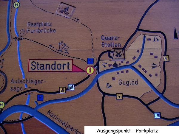
Beim Parkplatz, der sich direkt linker Hand am Ortseingang von Guglöd befindet, können sich Eure Kinder auf einem Waldspielplatz austoben.
Für Kinderwagen (Straßenversion) dürfte es bis auf die letzten 30 Meter kein Problem sein. Das Gleiche gilt für Radfahrer.

The noticeable series of rock structures known as "Bayerischer Pfahl" is one of the most remarkable geological disturbance zones of middle Europe.
Due to tectonic movements at the disturbance stones were deformed at a high temperature and changed to Mylonites.
Mylonites appear at disturbance zones through friction between two stone structures passing each other. The essential feature of Mylonites is the deformation of stone at a high temperature.
The Pfahl reaches - in an almost straight line - from the Oberpfalz in the northwest to a place near Linz (Austria ) in the southwest.
About 250 millions of years ago some fissures cracked open along the Pfahl. In the caverns of these fissures circulated thermalwater at a temperature of 572 °F. Mainly quartz was deposited during this circulation.
The shimmering white quartz of the pfahl consists up to 98% of silicic acid. Yellow to red and gray colorings are caused by iron compounds and impurity.
Quartz is the stable form of silicon oxide on the surface of the earth and the second common mineral of the earth´s crust right after feldspar.
On a scale from 1 to 10 where 10 is the hardest (diamond) quartz is relatively hard with an index of 7.
Quartz isn´t cleavable. It breaks like glass and shows a greasy gloss at the breakpoint.
It is assumed that here at this historic site near the town of Guglöd near Spiegelau quartz has been mined since the foundation of the glass foundries at Riedlhütte (1450) an Guglöd (1638).
Probably quartz was first mined at the surface and then in underground tunnels till 1873.
* * *
In order to log the cache answer the following questions and send them to me via GC-e-mail.
You´ll find the answers to the questions at the place.
1.) What is the chemical composition of quartz and of which 3 parts does it consist?
2.) Where did the quartz-prospectors and - gatherers exploit and collect quartz for the glass foundries of Riedlhütte, Guglöd and Neuriedlhütte in a period of about 420 years (from 1450 to 1877)?
3.) In which form does quartz that is embedded in the (at this place) widespread (cordierite-) gneiss appear?
4.) From when to when did the Roscher family own Riedlhütte?
5.) How high was the need of quartz for the glass factory in Riedlhütte in the year 1834?
6.) How many steps of stone did you have to take in order to descend to the goal?
Please log immediately (without waiting for my confirmation) and optionally post a picture of you and your GPRs in front of the entrance to the tunnels.
Logs which don´t meet the requirements are inappropriate!
If you´d like to take a look into the tunnels don´t forget to take a torch with you because the entrance is locked and with a torch you can at least take a look into the tunnels.
Entering the tunnels is prohibited at the moment.
Please keep that in mind.
Next to the parking lot which is situated left of Guglöd´s entrance there´s a playground where your children can play.
There might be a problem for strollers on the last 30 metres - the same counts for bikes.