[PL]
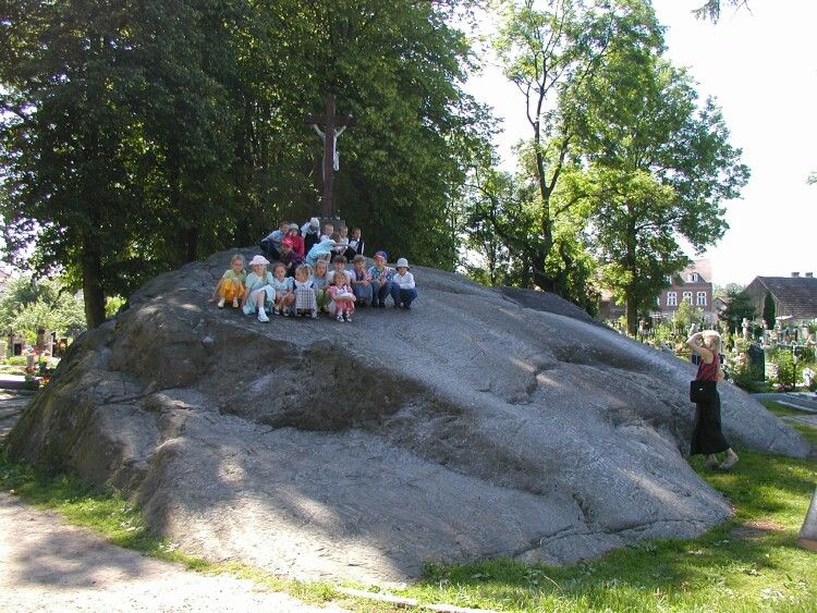
Tryglaw glaz narzutowy w miejscowosci Tychowo, w gminie Tychowo, w powiecie bialogardzkim, w wojewodztwie zachodniopomorskim), najwiekszy w Polsce. Znajduje sie na miejscowym cmentarzu.
Obwod glazu wynosi 50 m, dlugosc 13,7 m, szerokosc 9,3 m, laczna wysokosc 7,8 m (w tym 4 m zaglebione w ziemie); objetosc okolo 700 m3, szacowana waga ok. 2000 ton.
Eratyk, z ciemnoszarego gnejsu, przetransportowany zostal ze Skandynawii przez ostatnie zlodowacenie (polnocnopolskie). Na powierzchni wyraznie widoczne rysy – slady wleczenia przez ladolod.
Z glazem zwiazane sa liczne lokalne legendy, nazwa pochodzi od Tryglawa, ktorego zloty posag zakopany jest jakoby pod glazem. Podobno jeden z ksiazat Pomorza Zachodniego wjechal na niego karoca zaprzezona w cztery konie i zawrocil nia.
W 1874 niemieccy mieszkancy wzniesli na nim drewniany krzyz; obecnie corocznie w dzien Wszystkich Swietych kamien uzywany jest jako oltarz.
Od 1954 r. podlega ochronie prawnej jako pomnik przyrody
Aby zaliczyc ten Earthcache musisz przeslac mi e-mailem przez mój profil odpowiedz na nastepujace pytania:
1. Co jest w poblizu kamienia tego?
2. Gdzie sa nastepne kamienie (5 miescowosci) i dla czego tam sa?
Do logu mozes dolaczyc fotografie siebie z kamineniem.
[EN]
The glacial erratic Tryglaw is situated within the limits of the youngest, Vistulian (Weichselian) Glaciation. The Trygtaw erratic boulder represents a dark-grey Scandinavian paragranitgneiss oligoclase - andesitic of a size 50 metres in perimeter and 3.8 meters in height. Glacial polishings are well marked on the erratic surface. The boulder was transported from Scandinavia to Poland by the latest Scandinavian-Vistulian (Weichselian) ice-sheet (the glacial scratches on the surface) probably from the vicinity of Vidbo or Uppsala (Sweden).This glacial erratic is the bigiest of glacial erratic in Poland
A glacial erratic is a piece of rock that differs from the size and type of rock native to the area in which it rests. "Erratics" take their name from the latin word "errere", and are carried by glacial ice, often over distances of hundreds of kilometres. Erratics can range in size from pebbles to large boulders such as Big Rock.
Geologists identify erratics by studying the rocks surrounding the position of the erratic and the composition of the erratic itself. Erratics are significant because:
* Since they are transported by glaciers, they are one of a series of indicators which mark the path of prehistoric glacier movement. Their lithographic origin can be traced to the parent bed rock, allowing for confirmation of the ice flow route.
* They can be transported by ice-rafting,. This allows quantification of the extent of glacial flooding resulting from ice dam failure which release the waters stored in proglacial lakes such as Lake Missoula. Erratics released by ice-rafts that were stranded and subsequently melt, dropping their load, allow characterization of the high water marks for transient floods in areas like temporary Lake Lewis.
* Erratics dropped by icebergs melting in the ocean can be used to track Antarctic and Arctic-region glacial movements for periods prior to record retention. These can be correlated with ocean temperatures and levels to better understand and calibrate models of the global climate.
If you want to log this cache you have to send me via email what is near this glacial erratic and tell me next five location where can you find glacial erratic and why?
If you want you can make photo yourselves with the galcial erratic in the backgroud and

Earthcache is the most exciting way to learn about the Earth and its processes is to get into the outdoors and experience it first-hand. Visiting an Earthcache is a great outdoor activity the whole family can enjoy. An Earthcache is a special place that people can visit to learn about a unique geoscience feature or aspect of our Earth. Earthcaches include a set of educational notes and the details about where to find the location (latitude and longitude). Visitors to Earthcaches can see how our planet has been shaped by geological processes, how we manage the resources and how scientists gather evidence to learn about the Earth. To find out more click
HERE

