Geologiepark Modell des Ennstales EarthCache
Geologiepark Modell des Ennstales
-
Difficulty:
-

-
Terrain:
-

Size:  (other)
Related Web Page
Please note Use of geocaching.com services is subject to the terms and conditions
in our disclaimer.
 English Version
The Enns and its geological environment
In our Alps we distinguish lower and higher tectonical levels each with a most typical sequence of rock, which are pooled to geological units.
The Enns spans 254 kilometres and draws its water from an area of 6020km² (about 7% of Austria’s federal territory), a region that covers the federal states of Salzburg, Styria, Upper- and Lower Austria. Along its way it flows through a remarkable range of geological zones.
The river has its source in the mountains of Radstädter Tauern (Ennskraxn) at 1735m above sea level and starts flowing North at a considerable gradient. Near Wagrain its course turns into the wide U-shaped valley of Ennstalfurche, which follows the enormous system of fault lines called Ennstalstörung towards ENE. Basically, Ennstalfurche forms the borderline between two geological zones, the greywacke zone in the South and the Northern Calcareous Alps in the North. From this point as far as the Gesäuse the river shows minor gradient. Wet-meadows and swamps accompany the Enns and contribute significantly to the lovely scenery of this valley.
East of Admont the Enns takes a turn to the North and penetrates the limestone of the Northern Calcareous Alps in a wide trajectory. A section of cataracts, which is called “Gesäuse” due to the swooshing noise of the rushing water, passes through a canyon of towering, rugged rock face and is considered as the “heart” of the Enns.
Downriver to the Gesäuse a chain of hydroelectric dams retain the Enns’ water in order to make use of it for energy industry purposes.
Near Ternberg the Enns leaves the Northern Calcareous Alps and flows through the flysch zone as far as Steyr.
North of Steyr the Enns shaped the Alpine Foreland (molasse zone) significantly during the latest history of Earth and deposited thick layers of gravel, which formed scenic terraces.
Near the city of Enns the river meets the Danube.
To get credit for this Earthcache, please perform the following tasks and answer the questions:
1. Take a photo of you and your GPSr with or on Dachstein (optional).
2. Look for Spadenberg and figure out its weight; without base (density = 2.5 kg/dm³, don’t forget a measuring tape).
3. Walk along the Enns as far as the mouth. How many steps did it take for Mrs. MQ to get there?
a.) 100 b.) 130 c.) 160
Mail the answers to questions 2 and 3 to the Millquarter’s. Add the optional photo of task one to your log. If the answers are incorrect we will contact you.
 Deutsche Version
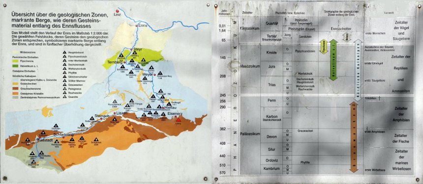
Die Enns und ihr geologisches Umfeld
Es lassen sich in unseren Alpen tiefere und höhere tektonische Stockwerke mit jeweils sehr typischen Gesteinsabfolgen unterscheiden, die zu geologischen Einheiten zusammengefasst werden.
Die Enns entwässert bei einer Gesamtlänge von 254 Kilometer ein Einzugsgebiet von 6080 km2 (ca. 7% des Bundesgebietes), das sich auf die Bundesländer Salzburg, Steiermark, Ober- und Niederösterreich aufteilt. Sie durchfließt dabei eine Vielzahl von geologischen Zonen.
Der Fluss entspringt in den Radstädter Tauern (Ennskraxen) in einer Seehöhe von 1735 m und fließt mit großem Gefälle in zunächst nördlicher Richtung. Bei Wagrein biegt sein Lauf in das weite Trogtal der Ennstalfurche, die dem gewaltigen Längsbruchsystem der Ennstalstörung nach ONO folgt. Im Wesentlichen bildet die Ennstalfurche die Grenzlinie zwischen zwei geologischen Zonen, der Grauwackenzone im Süden und den Nördlichen Kalkalpen im Norden. Von hier bis zum Gesäuse weist der Fluss ein geringes Gefälle auf. Nasswiesen und Moore begleiten die Enns und tragen zum landschaftlichen Reiz dieser Talschaft bei.
Nach Admont durchbricht die Enns, nun nördlich fließend, in weitem Bogen die Nördlichen Kalkalpen. Eine Kataraktsrecke , die wegen des Getöses des bewegten Wassers den bezeichnenden Namen „Gesäuse“ trägt, führt durch eine enge Schlucht mit steil aufragenden, zerklüfteten Felswänden und gilt als das „Herzstück“ der Enns.
Unterhalb des Gesäuses wird der Fluss durch eine geschlossene Staukette energiewirtschaftlich genutzt. Im Raume von Ternberg verlässt die Enns den Bereich der Nördlichen Kalkalpen und durchfließt bis Steyr die Flyschzone.
Nach Steyr prägte die Enns in der jüngsten Erdgeschichte das Alpenvorland (Molassezone) durch mächtige Schotterablagerungen. Es entstand eine reizvolle Terassenlandschaft.
Unterhalb der Stadt Enns mündet der Fluss in die Donau.
Um diesen Earthcache loggen zu dürfen, müsst ihr folgende Aufgaben erfüllen bzw. Fragen beantworten:
1. Macht ein Foto von euch und eurem GPSr mit oder auf dem Dachstein (optional).
2. Sucht den Spadenberg und bestimmt sein Gewicht; ohne Sockel (Dichte= 2,5 kg/dm3, Maßband nicht vergessen.)
3. Geht die Enns entlang bis zur Mündung. Wieviele Schritte hat Mrs. MQ dafür benötigt:
a.) 100 b.) 130 c.) 160
Sendet die Antworten auf die Fragen 2 und 3 an die Millquarter’s. Fügt eurem Log das optionale Foto von Aufgabe 1 hinzu. Ihr braucht die Logerlaubnis nicht abwarten. Sollten die Antworten falsch sein melden wir uns.
Additional Hints
(No hints available.)