Skip to content

Bily kriz - White Cross EarthCache

Hidden : 7/28/2012
Difficulty:
1.5 out of 5
Terrain:
3 out of 5

Size: Size:   other (other)

Join now to view geocache location details. It's free!

Watch

How Geocaching Works

Please note Use of geocaching.com services is subject to the terms and conditions in our disclaimer.

Geocache Description:


PŘÍRODNÍ REZERVACE BÍLÝ KŘÍŽ

Tabule

white cross 01
whote cross 02
white cross 03
white cross 04

Tvorí ji skalnaté svahy na levém, méne už i na pravém svahu hluboko zaríznutého údolí řeky Dyje pri jejím vtoku z Rakouska na území České republiky, okresu Znojmo v Uhercické pahorkatine, 2 km jižne od obce Uhercice.

Katastrální území: Stálky, Uherčice u Znojma, Vratěnín
Nadmořská výška: 360 m - 464 m
Výměra: 20,4696 ha
Vyhlášeno: 1996

Vápencové a amfibolitové skály nad oběma břehy řeky Dyje s teplomilnou flórou a reliktní vápnomilný bor.

Předmětem ochrany v přírodní rezervaci Bílý kříž je vegetace na prudkých, výslunných, skalnatých svazích s navazujícím druhově a věkově pestrým lesním porostem, zvláště chráněné druhy rostlin a živočichů, estetická hodnota území.

Vetší cást obnaženého skalního defilé tvorí vratenínská jednotka. Její soucástí jsou protažená telesa a cockovité polohy granátických amfibolitu, biotitické a biotiticko-muskovitické pararuly, ( Pararuly – přeměněné horniny, typ ruly, která vznikla vysokostupňovou přeměnou sedimentů) kvarcitu ( Křemenec – odolná hornina obsahující především křemen) a tremolitických mramoru. Podhradská jednotka, predstavovaná amfibolity a muskovit-biotitickými migmatitizovanými pararulami s granátem, je odkryta ve východní cásti výchozu. Na styku obou jednotek je patrné intenzivní provrásnení jednotlivých horninových teles.

mapka

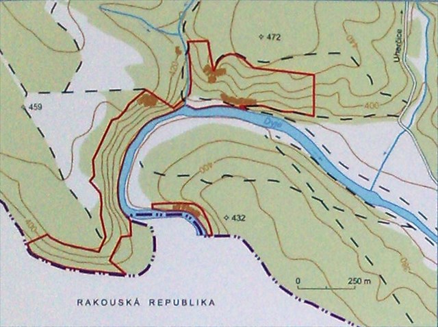
Dominantu tvorí 50 m vysoká skála. Žleby mezi skalnatýmí srázy jsou vyplneny sutemi a vápnitými svahovými hlínami. Východní cást území prekrývají sprašové náveje. Na svahovinách ostruvku vápencu se vyvinula rendzina kambizemní v celcích s kyselými i nasycenými hnedými pudami. V blízkém okolí se vyskytují dále i pseudogleje.

Uzemí tvorí mozaika lesu a ploch promárního bezlesí na skalách. Cást ploch zabírají typické hercynské cernýšové dubohabriny (Melampyro nemorosi-Carpinetum) s dominantním dubem zimním(Quercus petraea), habrem obecným (Carpinus betulus, lípou malolistou (Tilia cordata) a s bohatým bylinným podrostem, v nemž nechybí napr. lilie zlatohlávek (Lilium martagon) a bramborík nachový (Cyclamen purpurascens). Unikátním vegetacním typem je vegetace reliktních vápnomilných boru. V nich dominuje borovice lesní (Pinus sylvestris), v podrostu je hojná pechava vápnomilná (Sesleria albicans) a lopuštík sklonený (Hackelia deflexa).V olšine na brehu reky (Stellario-Alnetum glutonosae) se vyskytuje ojedinelá lokalita preslicky lucní (Equisetum pratense) spolu s porosty sneženky podsnežníku (Galanthus nivalis). V území se prirozene vyskytuje i tis cervený (Taxus baccata). Jde o jedno z nejdéle pretrvávajících míst,možná dokonce poslední,kde se vyskytoval v Ceské republice jason cervenooký (Parnassius apollo), který zde vymizel kolem roku 1935.

V prírodní rezervaci je povoleno chodit pouze po vyznacených cestách. Na závěr malé upozornění, výchozí souřadnice Vás dovedou k místu, kde můžete pozorovat meandry Dyje s nádherným výhledem na okolní krajinu. Pokud půjdete dolů k řece jsou zde dřevěné nezajištěné schody , raději je nevyužívejte a jděte lesem podél těchto schodů, za mokra opravdu kloužou !!!
 
Podmínky pro logování Found It:
 
   1. Zjistit a odeslat pres muj profil na GC.com:
          * nadmorskou výšku na výchozích souradnicích
          * jaký objekt se nachází na výchozích souradnicích
          * uvedte prevládající drevinu v tomto míste
          * v blízkosti řeky nalezněte u WP1 výše uvedené provrásnění, v jeho blízkosti je malý objekt, popište co jste našli.
   2. Do logu vložit fotku vaší GPS s meandrující rekou Dyjí v pozadí, (samozrejme mužete zaslat i vaše foto s temito meandry Dyje)* tato podmínka je dobrovolná
 

Literatura: Brněnsko-chráněná území ČR – Agentury ochrany přírody a krajinyČR, (EkoCentrum 2007)

Poděkování

  • Do anglického jazyka přeložila Katka Luzarová
  • Do němčiny přeložila Martina Lasar (Waldente)
  • WEB design LunaWZN

white cross 10 white cross 11 white cross 9

NATURE RESERVE WHITE CROSS

Bílý Kříž Nature Reserve comprises rocky slopes of the left side and less of the right side of the deeply cut valley of the Dyje River at the point where the river flowing from Austria enters the Uherčice Hilly Land, 2 km south from the village of Uherčice lying in Znojmo District.

Cadastral district: Stálky, Uherčice u Znojma, Vratěnín
Altitude: 360 m - 464 m
Area: 20,4696 ha
Year of designation: 1996

Limestone and amphibolitic rocks overlooking both banks of the Dyje River with a thermophilic flora; and calcareous pine-wood.

Subject matter of protection in Bílý Kříž Nature Reserve is vegetation on steep, sunny rocky slopes with species and age-related varied forest vegetation, particularly protected species of plants and animals; as well as aesthetic value of the area.

Greater part of bare rocky defile consists of Vratěnín Unit. It comprises elongated bodies and lenticular layers of garnet amphibolite, biotic and biotitic-muscovitic paragneisses (Paragneisses – metamorphic rocks, kind of gneiss formed by high-grade metamorphic process of sedimentary rocks), quartzite (quartz rock – resistant rock containing primarily silica) and tremolite limestone. Podhradí Unit represented by amphibolites and muscovite-biotitic migmatitic paragneisses with garnet is exposed in the eastern part of the outcrop. An intensive folding of individual rock bodies is apparent at the boundaries of the both units. The area is dominated by a 50-metre high rock. Gullies between the rock cliffs are filled with detritus and calcareous sloping clays. The eastern part of the area is covered by loess sediment. Cambic Rendzina altogether with acid and saturated brown soils has developed on deluviums of limestone islets. Pseudogleys also occur in the nearest surroundings.

mapka

The territory is home to forests and areas of primary nonstocked forest land on the rocks. It is partly overgrown with typical Hercynian cow-wheat oak and hornbeam woods (Melampyro nemorosi-Carpinetum) with prevailing Sessile Oak (Quercus petraea), Common Hornbeam (Carpinus betulus), Small-leaved Lime (Tilia cordata) as well as rich herbaceous undergrowth where for example Turk’s-cap Lily (Lilium martagon) and Deep Red Cyclamen (Cyclamen purpurascens) are not missing. The unique vegetation type is represented by relict calcareous pine-woods. These are dominated by Scots Pine (Pinus sylvestris); the undergrowth is abundant in blue Selseria (Sesleria albicans) and Northern Stickseed (Hackelia deflexa). Alder carr forest (Stellario-Alnetum glutonosae) on the riverbank is the unique habitat of Meadow Horsetail (Equisetum pretense) together with Common Snowdrop (Galanthus nivalis). The area is also a natural habitat of European Yew (Taxus baccata). It is one of the last places in the Czech Republic where Mountain Apollo (Parnassius apollo) ranged for a long time and vanished in 1935.

Within the nature reserve it is permitted to walk on the designated trails only. Just a small notice – the initial coordinates will take you to a place where you can observe the meandering Dyje River and where you will get a wonderful view of surrounding landscape. There are wooden unsecured stairs leading to the river. Should you decide to go downhill, take a walk through the forest neighbouring the stairs instead of using them. Steps are really slippery when wet!!! 

To log this earthcache:
 
   1. Mail responses to the following questions through my geocaching profile:
          * What is the altitude of the initial coordinates?
          * What is to be found on the site of the initial coordinates?
          * Which woody plant prevails in this place?
          * Find the above-mentioned folding near the WP1, close to the river. Describe a small natural phenomenon lying nearby.
   2. Upload a photo of your GPSr with the meandering Dyje River in the background (You can certainly attach a picture of youself with the river in the background). * This requirement is optional.

white cross 14

white cross
white cross 7
white cross
white cross
white cross

References: Brno Region – Protected Areas in the Czech Republic, Agency for Nature Conversation and Landscape Protection, (EkoCentrum 2007)

Thanks

  • Translated into English Katka Luzarová
  • Translated into German by Martina Lasar (Waldente)
  • WEB design LunaWZN

white cross white cross white cross 16

DAS NATURSCHUTZGEBIET WHITE CROSS (Weißes Kreuz)

Das Bílý Kríž Naturschutzgebiet besteht aus felsigen Hängen auf der linken Seite und weniger auf der rechten Seite des tief eingeschnittenen Tals der Thaya an der Stelle, wo der Fluss von Österreich in das hügelige Land rund um Uhercice fließt, 2 km südlich vom Dorf im Bezirk Znaim.

Katastralgemeinde:

Stálky, Uherčice u Znojma, Vratěnín

Höhe:

360 m - 464 m

Gebiet:

20,4696 ha

Jahr der Bezeichnung:

1996

An intensive folding of individual rock bodies is apparent at the boundaries (Grenze) of the both units. The area is dominated by a 50-metre high rock. Gullies between the rock cliffs are filled with detritus and calcareous sloping clays.

Im Naturschutzgebiet ist es nur auf den bezeichneten Strecken erlaubt zu wandern. Nur ein kleiner Hinweis - die Anfangskoordinaten werden Sie zu einem Ort führen, an dem Sie den mäandernden Fluss Thaya beobachten und wo Sie einen herrlichen Blick auf die umgebende Landschaft nehmen können. Es gibt eine ungesicherte Holztreppe zum Fluss. Sollten Sie sich entscheiden bergab gehen, machen Sie einen Spaziergang nebenan durch den Wald statt über die Treppe. Die Stufen sind bei Nässe wirklich rutschig !!!

Um den Cache als "gefunden" loggen zu können, müssen Sie folgende:

  1. Angaben herausfinden und an meine Profiladresse senden:
    • Anfangshöhe (Höhe bei den Anfangskoordinaten) was können Sie auf dem Gelände der ursprünglichen Koordinaten finden?
    • wie lautet der Name des an diesem Ort vorherrschenden Gehölzes?
    • finden Sie die oben genannte Falten in der Nähe des WP1, in der Nähe des Flusses. Beschreiben Sie ein kleines Naturphänomen, das sich in der Nähe befindet. Wie hoch und tief ist es?
  2. Laden Sie ein Foto Ihres GPS-Gerät mit dem mäandernden Fluss Thaya im Hintergrund hoch (Sie können auch ein Foto von sich mit dem Fluss im Hintergrund senden). * Diese Anforderung ist optional.

Fachliteratur: Brno-Schutzgebiete der Tschechischen Republik - Agentur für Naturschutz und Landschafts (Ekocentrum 2007)

Danksagungen

  • Übersetzt ins Englische Katka Luzarová
  • Übersetzt ins Deutsche Martina Lasar (Waldente)
  • WEB-Design LunaWZN

created by LunaWZN@2010-2016


Additional Hints (No hints available.)