#3 Zanikle obce - Mlyny pod Sv. Sebestianem Multi-cache
#3 Zanikle obce - Mlyny pod Sv. Sebestianem
-
Difficulty:
-

-
Terrain:
-

Size:  (small)
Please note Use of geocaching.com services is subject to the terms and conditions
in our disclaimer.
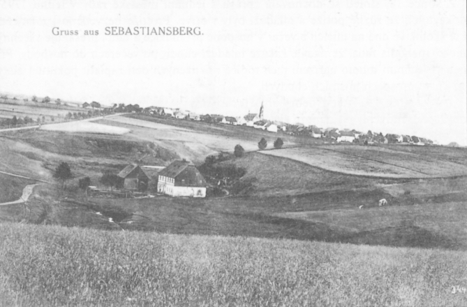
#3 Zaniklé obce - Mlýny pod Sv. Šebestiánem
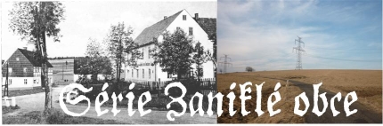
Toto je tretí cache ze série Zmizelé obce, která vás provede po obcích a zajímavých místech Chomutovska, které byly postupem casu opušteny a príroda nad nimi opet prebírá nadvládu. Ke každému místu je priložena podrobná mapa z konce 30. let, na které mužete porovnat aktuální stav s historií dávno minulou.
This cache is the third one from the series Disappeared villages. This series will guide you to villages and interesting places around Chomutov abandoned during the years. For each place is attached a precise map from the late 30´s which will help you to compare the history with the present state.
 Pohled na 3. mlýn. Binterová (2009)
V Bezrucovo údolí jsou všem známé Dolské mlýny (mužete navštívit pri lovu GC1R9ET). Málokdo však ví, že v Bezrucovo údolí bylo mlýnu daleko více. Nalézaly se na zacátku Bezrucova údolí, pod obcí Hora Sv. Šebestiána. V dnešní dobe mužeme z techto mlýnu nalézt zbytky náhonu, základy staveb a dokonce osy mlýnských kol. Tato multi-cache vás provede po ctyrech mlýnech, ze kterých byly dle Binterové (2000) dva klasické mlýny a dva sloužily jako pila. V knize je i zmínka, že jeden sloužil pro mlení kamení, pri výstavbe železnicní trati Krimov-Reizenhein.
In the Bezruc valley are very well known water-mills (visit them at GC1R9ET). Not so many people knows that there were much more mills in the Bezruc valley. They were situated in the beginning of the walley, below the town Hora Sv. Šebestiána. Nowadays we may still find the remains of supply-ditch, building basements or even axles of the mill-wheels. This multi-cache will guide you along the four mills - of which were two, along Binterová (2000), classical mills and two were water-powered-saw.
1. mlýn - stage 1
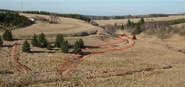
Teoretická poloha tohoto mlýna byla urcena zamerením GPS, protože z vlastní stavby mlýna již nic nezbylo. Jediné patrné jsou pozustatky hráze nádrže, která zadržovala vodu pro mlýn. Od tohoto mlýna zacíná vodní náhon, který napájel 2., 3. a 4. mlýn.
Jednotlivé STAGE jsou cerné PET kapsle.
The theoretical position of this mill was determined my GPS measuerements, because from the building itself is nothing left. Only visible part are the remains of the reserovir damming - which was supporting the mill with water. From this point is starting the supply ditch for the 2nd, 3rd and 4th mill.
All the stages are black PET capsules.
2. mlýn - stage 2
U druhého mlýna najdeme zbytky nádrže, která zadržovala vodu pro mlýn, spolu betonovou hrází. Krásne patrné je i místo, kde zrejme bývalo vodní kolo. Z mlýna zustala nízká podezdívka a zrejme zbytek mlýnice. Pred budovou mlýna jsou videt zbytky zdí (pudorys) další budovy. Od 2. mlýna vede opet cca 100m dlouhý vodní náhon, který napájel nádrž (pomerne velkou) zásobující vodou 3. a 4. mlýn.
At the second mill we discover remains of the water reservoir with damming. Very well is visible place, where used to be the mill-wheel. From the mill have raminded the basements. In front of the building are visible basements of another building. From the second mill is 100m long supply-ditch supplying quite large water reservoir supporting the third and fourth mill.
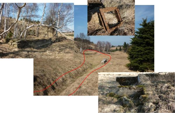
3. mlýn - final stage
Ke 3. mlýnu vede krásne viditelný vodní náhon. Z mlýna zbyly základy, cást sloupu se zbytkem nápisu a osa mlýnského kola.
There is a well visible water-supply-ditch going to the third mill. We can find there remains of basements of the building, pillar remains with some writing and the mill-wheel axis.
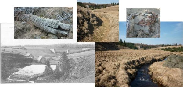
4. mlýn - dobrovolná stage/reference point
Polohu 4. mlýna jsem objevil jen díky presnému odectu souradnic z mapy a následném zamerení GPS. Poloha mlýna se dá vysledovat díky prubehu vodního náhonu. V lokalite puvodní stavby je patrný pudorys, zbytky zdí a osa mlýnského kola.
The position of the 4th mill was discovered by GPS navigation to computed coordinates. In the mill-locality are visible some wall-remains a the mill-wheel axis.
CACHE:Tato cache je vytvorena jako "zážitková" = není primárne urcena k výmene (trade) vecí. Uvnitr je nekolik drobností pro potešení detských cacheru - proto prosím mente s rozumem a s ohledem k dalším detským návštevníkum. Trackovatelné predmety, CWG a další jsou vítány. Uvnitr cache je uložena zalaminovaná mapa, vcetne základních informací a dobových snímku - TOTO NENÍ PREDMET NA VÝMENU - mužete se tak stát objeviteli a zkusit identifikovat jednotlivé stavby, poprípade najít stopy po osídlení. Na mnoha místech této série se dají najít kusy nádobí, dlaždic, lahví, a další zajímavé veci. Uvnitr cache najdete indicii k odlovení finále série – Sv. Anna - GC27GE9.
CACHE:This cache is ment to an „experience cache“ = it is primarily not dedicated for trading. Inside are some small things to satisfy the kid-gecachers – so please trade with respect to future children-discoverers. Trackable items are welcome. In the final stage is laminated map together with basic information and old pictures – THIS IS NOT A TRADING ITEM – you can try to be a discoverer and identify the old houses or to find some remains of the former habitation. On many places of this series you can find pieces of dish, tiles, bottles and other interesting things. Inside the cache you will find the part of the coordinates of the FINAL of this series - Sv. Anna- GC27GE9.
Cache série: Celá série je pripravena tak, aby se dala projet v rozumném okruhu na kole - se startem a cílem u 3. mlýna v Bezrucove údolí. Okruh merí presne 50km a je pouze pro zdatné cyklisty - celkové prevýšení trasy je 2200m (1100m stoupání a 1100m klesání). Zájemcum mohu zaslat trasu v GPX. Doporucuji však hledání rozložit do více dní - abyste meli dostatek casu si všechna místa dukladne prohlédnout. Jízdní kolo (poprípade kolobežka) je vítaným doplnkem - zkrátí cestu od potencionálního parkovište ke cache.
Cache series: The whole series is prepared so you can bike through it in a circle with start and finish at the 3 rd mill at the Bezruc valley. The circle measures cca 50km and is for good bikers only – the total elevation of the track is 2200m (1100m uphill and 1100 downhill). If you are interested, I can send you the track in GPX. I recommend to split the search into several days, so you can enjoy each of the places. Bike is anyway recommended – it will make the trip from parking to caches shorter and faster.
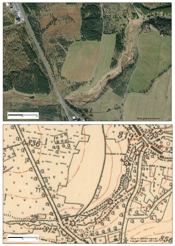 Poloha mlýnu na leteckém snímku na mape III. vojenského mapování
#1 Zaniklé obce - Stráž (Tschoschl)
#2 Zaniklé obce - Menhartice (Märzdorf)
#3 Zaniklé obce - Mlýny pod Sv. Šebestiánem
#4 Zaniklé obce - Mlýny pod Novou Vsí
#5 Zaniklé obce - Jilmová (Ulmbach)
#6 Zaniklé obce - Pohranicní (Reizenhein)
#7 Zaniklé obce - Kienheid
#Finále - Zaniklé obce - Sv. Anna
Additional Hints
(Decrypt)
Fgntr 1: oevmn/ovepu
Fgntr 2: qven/ubyr
Svany: ancvf/jevggvat