#2 Zanikle obce - Menhartice (Marzdorf) Traditional Geocache
#2 Zanikle obce - Menhartice (Marzdorf)
-
Difficulty:
-

-
Terrain:
-

Size:  (small)
Please note Use of geocaching.com services is subject to the terms and conditions
in our disclaimer.
#2 Zaniklé obce - Menhartice (Märzdorf)
Toto je druhá cache ze série Zmizelé obce, která vás provede po
obcích a zajímavých místech Chomutovska, které byly postupem casu
opušteny a príroda nad nimi opet prebírá nadvládu. Ke
každému místu je priložena podrobná mapa z konce 30. let,
na které mužete porovnat aktuální stav s historií dávno
minulou.
This cache is the third one from the series Disappeared
villages. This series will guide you to villages and interesting
places around Chomutov abandoned during the years. For each place
is attached a precise map from the late 30´s which will help you to
compare the history with the present state.
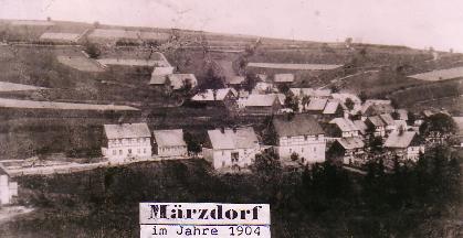
Menhartice ležely na pravém brehu Menhartického potoka, v
nadmorské výšce 725 m. Od Chomutova byly vzdáleny 10 km SZ
smerem a od Hory Svatého Šebestiána 3 km na VJV Katastr
meril 506 hektaru.
První osadníci byli uhlíri a jejich osada stávala údajne více na
západ. Nedostatek vody je prý donutil premístit svá obydlí
níže.
Vesnice mela dve cásti: v té starší stávaly domy kolem
návsi, na které byla pozdeji, až v roce 1850, postavena
kaplicka, zasvecená svatému Floriánovi. Domy novejší cásti
lemovaly ulici, vycházející z návsi na jihovýchod, smerem k jednomu
ze trí menhartických rybníku. Zatímco kolem návsi byly zemedelské
usedlosti, v domcích u silnice bydleli delníci, pracující v lese
nebo na dráze.
Do konce 1. svetové války zde žilo jen nemecké obyvatelstvo, v
roce 1921 zde bylo již 5 Cechu. Ješte pred 2. svetovou
válkou patrily Menhartice k bohatým vesnicím, po odsunu Nemcu se
však již nepodarilo ves dosídlit.
Když bylo pocátkem 50. let rozhodnuto o výstavbe vodní
nádrže Krimov, bylo tím rozhodnuto i o zrušení
Menhartic, ležících ve druhém ochranném pásmu nádrže na
pitnou vodu. Dnes v místech, kde ves stávala, najdete jen nekolik
zbytku zdí a rybníky.
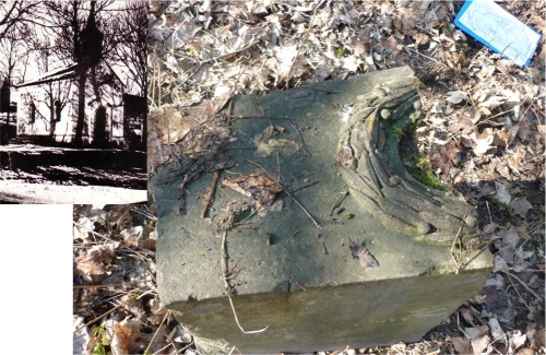 Že by kousek kaple?
Menhartice were situated on the right side of the Menhartice brook,
in the altitude of 725m. 10km NW from Chomutov and 3km SE from Hora
Sv. Šebestiána. The area of the village was about
506ha.
The first inhabitans were the charcoal-burners and their village
was located more to the west. Insufficient water supplies forced
them to move a little lower. The village had two parts - in the
older one were houses situated around the village-square, where was
in 1850 built a chapel dedicated to St. Florian. Houses of the
newer part stood along the street.
Until the end of WWI lived in Menhartice only German inhabitans. In
the year 1921 were living there 5 Czech inhabitans. Before the WWII
were Menhartice a very rich village. After the "deportation" of
German inhabitans were Menhartice never fully inhabited.
In the begining of 1950´was desided to built the water-dam Krimov -
Menhartice layed in the 2nd protetction area, and therefore were
destroyed.
CACHE:Tato cache je vytvorena jako "zážitková" =
není primárne urcena k výmene (trade) vecí. Uvnitr je nekolik
drobností pro potešení detských cacheru - proto prosím mente
s rozumem a s ohledem k dalším detským návštevníkum.
Trackovatelné predmety, CWG a další jsou vítány. V cache je
uložena zalaminovaná mapa puvodní obce, vcetne základních
informací a dobových snímku - TOTO NENÍ PREDMET NA VÝMENU -
mužete se tak stát objeviteli a zkusit identifikovat
jednotlivé stavby, poprípade najít stopy po osídlení. Na mnoha
místech této série se dají najít kusy nádobí, dlaždic, lahví,
a další zajímavé veci. Uvnitr cache najdete indicii k
odlovení finále série – Sv. Anna -
GC27GE9.
Pokud ke cache pojedete autem - doporucuji jej zaparkovat u
hájovny (PARK1) a pokracovat pešky pres Stráž (cca
2.5km chuze). Zde mužete odlovit první cást série –
Stráž -
GC26BP8. Další možnost je zaparkovat na PARK2 v
Nové Vsi – a vydat se po ceste viaduktem pod silnicí na Horu
Sv. Šebestiána – cca 2.5km. Na kole je tato cache
dostupná z mnoha smeru. Dále mužete pokracovat na Mlýny pod
Novou Vsí
GC26JFR.
CACHE:This cache is ment to an „experience
cache“ = it is primarily not dedicated for trading. Inside
are some small things to satisfy the kid-gecachers – so
please trade with respect to future children-discoverers. Trackable
items are welcome. In the cache laminated map of the original
village together with basic information and old pictures –
THIS IS NOT A TRADING ITEM – you can try to be a
discoverer and identify the old houses or to find some remains of
the former habitation. On many places of this series you can find
pieces of dish, tiles, bottles and other interesting things. Inside
the cache you will find the part of the coordinates of the FINAL of
this series - Sv. Anna-
GC27GE9.
If you are coming by car – park it by the lake at PARK1
and than walk across Stráž (cca 2.5km). In Stráž you may
hunt the first part of the series – Stráž -
GC26BP8. Other possibility is to park at Nová Ves (PARK2) - and
walk through the tunnel under the road to Hora Sv.
Šebestiána - cca 2.5km. On the bike is this cache reachable
from different directions. Then you may move on to Mlýny pod Novou
Vsí
GC26JFR.
Cache série: Celá série je pripravena tak, aby se
dala projet v rozumném okruhu na kole - se startem a cílem u 3.
mlýna v Bezrucove údolí. Okruh merí presne 50km a je pouze pro
zdatné cyklisty - celkové prevýšení trasy je 2200m (1100m
stoupání a 1100m klesání). Zájemcum mohu zaslat trasu v GPX.
Doporucuji však hledání rozložit do více dní - abyste
meli dostatek casu si všechna místa dukladne prohlédnout.
Jízdní kolo (poprípade kolobežka) je vítaným doplnkem - zkrátí
cestu od potencionálního parkovište ke cache.
Cache series: The whole series is prepared so you can bike
through it in a circle with start and finish at the 3 rd mill at
the Bezruc valley. The circle measures cca 50km and is for good
bikers only – the total elevation of the track is 2200m
(1100m uphill and 1100 downhill). If you are interested, I can send
you the track in GPX. I recommend to split the search into several
days, so you can enjoy each of the places. Bike is anyway
recommended – it will make the trip from parking to caches
shorter and faster.
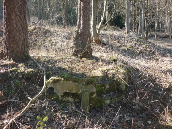 Schudky na již neexistující
predzahrádku
Schudky na již neexistující
predzahrádku

#1 Zaniklé obce - Stráž (Tschoschl)
#2 Zaniklé obce - Menhartice (Märzdorf)
#3 Zaniklé obce - Mlýny pod Sv. Šebestiánem
#4 Zaniklé obce - Mlýny pod Novou Vsí
#5 Zaniklé obce - Jilmová (Ulmbach)
#6 Zaniklé obce - Pohranicní (Reizenhein)
#7 Zaniklé obce - Kienheid
#Finále - Zaniklé obce - Sv. Anna
Text prevzat:
Zdena Binterová, Historictí svedkové doby v euroregionu
Krušnohorí, vydavatel: Zaniklé obce a mesta chomutovského
regionu, o.p.s., se sídlem v Perštejne, 2000
Additional Hints
(Decrypt)
PM: Ovyr bzvgahgn mrq - qbyr.
RAT: Juvgr cnvagrq jnyy - qbja.