|
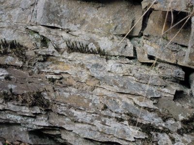
Fenster der Erdgeschichte
 In Westeuropa verhüllt normalerweise eine mehr oder weniger dicke Bodenkrume die darunter liegenden Gesteine. Eingriffe des Menschen in den Untergrund, wie zum Beispiel Steinbrüche, bieten jedoch die Möglichkeit die vor Ort anstehenden Gesteine zu erkunden und geologisch zu erforschen. An den Wänden dieses Steinbruchs, in dem einst Material zum Wege- und Straßenbau gewonnen wurde, gibt die Vegetation auch viele Jahre nach Stilllegung des Abbaus einzelne Stellen frei, an denen die Gesteinsschichten gut zu erkennen sind. Kompakte und daher deutlich hervortretende Bänke unterschiedlicher Dicke bestehen aus Sandstein. Sie wechseln sich mit Lagen aus geschiefertem Ton- und Schluffstein ab, die umgangssprachlich als „Schiefer" bezeichnet werden. Die Schichten an der Siegquelle entstanden wie die meisten der im Rheinischen Schiefergebirge auftretenden Gesteine aus Meeresablagerungen. Im Erdaltertum, vor 400 - 360 Mio. Jahren, bedeckte ein Meer weite Teile des heutigen Mitteleuropas. Einzelne Versteinerungen (Fossilien) in den Schichten an der Siegquelle zeugen davon. In Westeuropa verhüllt normalerweise eine mehr oder weniger dicke Bodenkrume die darunter liegenden Gesteine. Eingriffe des Menschen in den Untergrund, wie zum Beispiel Steinbrüche, bieten jedoch die Möglichkeit die vor Ort anstehenden Gesteine zu erkunden und geologisch zu erforschen. An den Wänden dieses Steinbruchs, in dem einst Material zum Wege- und Straßenbau gewonnen wurde, gibt die Vegetation auch viele Jahre nach Stilllegung des Abbaus einzelne Stellen frei, an denen die Gesteinsschichten gut zu erkennen sind. Kompakte und daher deutlich hervortretende Bänke unterschiedlicher Dicke bestehen aus Sandstein. Sie wechseln sich mit Lagen aus geschiefertem Ton- und Schluffstein ab, die umgangssprachlich als „Schiefer" bezeichnet werden. Die Schichten an der Siegquelle entstanden wie die meisten der im Rheinischen Schiefergebirge auftretenden Gesteine aus Meeresablagerungen. Im Erdaltertum, vor 400 - 360 Mio. Jahren, bedeckte ein Meer weite Teile des heutigen Mitteleuropas. Einzelne Versteinerungen (Fossilien) in den Schichten an der Siegquelle zeugen davon.
Sedimentationsmerkmale: Fingerabdrücke des Ablagerungsraumes
|
Die Ablagerungen im Steinbruch an der Siegquelle enthalten charakteristische Merkmale, die Rückschlüsse auf den Ablagerungsraum (Sedimentationsraum) ermöglichen. So zeigen z. B. die Trennflächen zwischen den Lagen und Bänken (die Schichtflächen) wellenförmige Erhebungen und Vertiefungen. Einzelne Sandsteinbänke verlieren an Mächtigkeit oder keilen sogar ganz aus, während andere dafür anschwellen. Auch innerhalb einzelner Bänke und Lagen sind besondere Sedimentationsmerkmale ausgebildet.
|
 |
|
Semdimentschichten
|
Vergleich zwischen gestern und heute
|
Die Gesteine an der Siegquelle wurden zur Unterdevon-Zeit abgelagert. Vergleicht man ihre Sedimentationsmerkmale mit denen von Ablagerungen, die sich gegenwärtig bilden, so stellt man eine hohe Übereinstimmung dort fest, wo heute große Flüsse mit breiten Mündungstrichtern ihre Sedimentfracht ins Meer abladen.
Gute Beispiele dafür sind das Nil-, Ganges- oder Mississippi-Delta. Diese Deltabereiche zeichnen sich unter anderem durch eine geringe Wassertiefe aus, so dass der Wellengang auf dem Meeresboden (im Sediment) Wellenrippeln ausbilden kann.
|

|
|
Gesteinsblock mit Wellenrippel
|
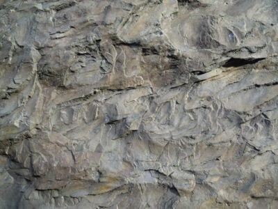 |
Auf der Steinbruchsohle, auf der die Infotafel steht, sind wellenförmige Erhebungen und Vertiefungen ausgebildet, die bei genauer Betrachtung an Wellenrippel erinnern, so wie wir sie zum Beispiel vom Nordseestrand her kennen. In der Tat steht die Infotafel auf einem versteinerten (fossilen) Meeresboden, den das Devon-Meer vor mehreren Millionen Jahren schuf.
|
|
Wellenrippel in Nahaufnahme
|
|
Ihr könnt sofort loggen. Sendet mir die Antworten unter Angabe Eures Cachernames und/oder Eurer E-Mail. Ich melde mich, wenn etwas nicht stimmt. Über ein Foto von Euch und Eurem GPS vor Ort würde ich mich freuen.
1. Welches Tier ist in der Tabelle im Zeitalter des Devon abgebildet? (lt. Infotafel)
2. Vor wie viel Millionen entstand der versteinerte Meeresboden, auf dem du vor der Infotafel stehst? (lt. Infotafel)
Bitte die Antwort an meinen GC-Account senden. Der Geocache darf sofort geloggt werden, bei Problemen melden ich mich.
|
Window of the earth history
 In Western Europe a more or less thick top soil covers the rock underneath. Interferences of the human beings in the subsoil, like quarries for example, offer the possibility to explore and study the local rocks geologically. In Western Europe a more or less thick top soil covers the rock underneath. Interferences of the human beings in the subsoil, like quarries for example, offer the possibility to explore and study the local rocks geologically.
On the walls of this quarry, where mining of material for street construction once took place, the vegetation uncovers, even years after the close down, some spots, where you can see the different beds of the rock. Compact and therefore clearly stressed beds of different thickness are composed of sandstone. They take turns with layers of clay and siltstone, called slate in colloquial language. The beds at the source of the Sieg originate, like most of the deposit of the rocks of the (Rheinische Schiefergebirge) slate mountains of the Rhineland of sedimentary deposition. In the ancient past of the earth , 400 – 360 mill. ago, an ocean covered most parts of the today’s Central Europe. Single fossils in the beds at the source of the Sieg show this.
Characteristic sedimentation, fingerprints of the area of deposit
|
The accumulations in the quarry at the source of the Sieg contain characteristic attributes which make it possible to draw conclusions from the area of deposit. Therefore the joint faces between the layers and the benches show elevations and deepenings in waveform.
Single sandstone benches lose thickness or have a different shape, while others swell. Also within single benches and layers characteristic sedimentation are formed.
|
|
|
Sedimentary deposition
|
Comparison between yesterday and today
|
The rocks at the source of the Sieg matured in Underdevon-times. Comparing these characteristic sedimentation with the accumulations composed nowadays you realize a high degree of conformance where today big rivers with wide estuary mouths unload their sediment. Good examples for this are the delta of the Nile,-Ganges or Mississippi.
These delta areas display among other things a low depths of water , so the swell on the ground of the ocean form wave ridges.
|
|
|
Rock with wave ridges
|
|
On the ground of the quarry, where you can find an information board, there are elevations and deepenings in shape of wave ridge which look like the ones we know from the beaches of the North Sea. In fact the information board is located on the (fossilized) ocean bed, which the Sea of Devon developed millions of years ago.
|
|
Close-up of wave ridges
|
|
You can log right away.
A picture of yourself and/or the GPS in front of the information board of the quarry or the rock with the ridges and answer the following questions would be nice:
1. Which animal is pictured in the chart of the era of Devon?
2. How many million years ago the fossilized ocean bed was formed?
|