Das Saaletal prägt die Landschaft um Bad Neustadt.
Hier im Tal ist die Fränkische Saale noch nicht verbaut und eingeengt.
Deshalb wurden diese Wiesen 1999 zum Naturschutzgebiet ernannt. Es stehen insgesamt 155 ha unter Schutz.
Diese Wiesen sind ein Bestandteil im
europäischen Schutzgebietsnetz „Natura 2000“.
Die Wiesen haben eine wichtige Funktion im Frühjahr, dann dienen sie als Rückstaufläche für die Wassermassen
bei der Schneeschmelze in der Rhön. Viele Tierarten nutzen diesen Bereich des Saaletals zur Brut und Jungenaufzucht.
Jetzt kommt noch eine geologische Besonderheit dazu, die man nicht so einfach sieht. In den Wiesen gibt es Stellen, an denen Salzwasser
aus der Tiefe an die Oberfläche kommt. Deshalb wachsen dort Pflanzen, die sonst nur an den Meeresküsten der Nord- und
Ostsee vorkommen. Die Salzwiesen hier sind einzigartig und sind die einzigen noch bekannten Salzwiesen in Süddeutschland.
Die Salzflora hier beinhaltet u.a. Salzdreizack und Salzbinse.
Die sauren Wiesen mit der typischen Salzflora verdanken ihre Existenz der besonderen geologischen Schichtung.
Vor ca. 230 Millionen Jahren hat sich das Meer zurückgezogen dabei sehr dicke Salzlager zurückgelassen. Zur dieser Zeit
herrschte hier ein warmes tropisches Klima. Das Wasser verdunstete und das Salz blieb zurück und ist heute unter ca. 700 m
mächtigen Bundsandsteinschichten im Zechstein eingelagert.
Über die Jahrtausende und durch vulkanische Aktivität entstanden Risse in den Gesteinsschichten.
Über diese Risse gelangen Grundwasser und Regenwasser in die Zechsteinschicht und lösen darin die Salze und Mineralstoffe.
In feineren Rissen steigt das salzhaltige Wasser durch den Kapillareffekt wieder an die Oberfläche.
Die Austrittsstellen findet man nur, wenn man nach den oben genannten Salzpflanzen im Tal Ausschau hält.
Im Sommer erkennt man auch einige grüne Stellen inmitten der Wiese, wo sonst schon alles gelb bis braun ist.
Fragen zum Loggen:
Aus welcher Tiefe kommt das Solewasser an die Oberfläche?
Wie dick kann die Zechsteinschicht werden?
Welche hier anzutreffende Salzpflanze trägt eine Obstsorte in ihrem Namen?
Ein Foto vom Cacher mit dem Quellenadler im Hintergrund. (großer Adler aus Edelstahl in der Nähe)(keine Logbedingung wäre aber schön, Es darf direkt geloggt werden. Wir melden uns wenn es Unstimmigkeiten gibt.) 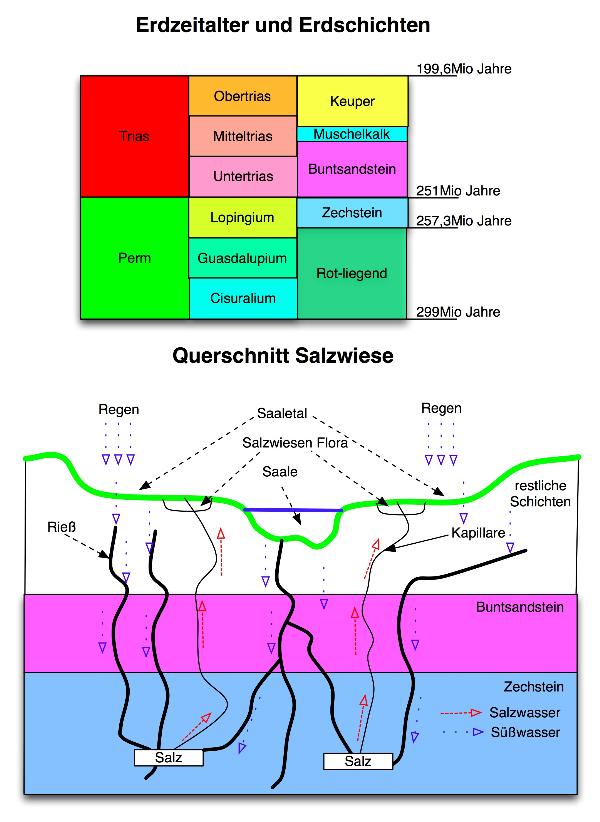
The valley of the river Saale is essential for the landscape around the city of Bad Neustadt.
The river Saale (or, to be exact : Fränkische Saale) still floats free in this part of the valley, there are no buildings on both banks of the river.
Therefore this area has beeen declared a nature reserve in
1999.
The nature reserve has a size of more than
380 acres.
These meadows are a part of the net of nature reserves „Natura 2000“.
The meadows have got an important function in spring. The thaw in the region Rhön lets the water-levels of the streams and rivers rise.
The enormous additional amount of water in the river Saale floats on these meadows instead of causing floods in the downstream cities and villages.
Many animals rise there young ones in this area near Bad Neustadt. One of them is the bird Wachtelkönig (corn crake / landrale / crex crex).
And there is another peculiarity, a geological one which can not be seen so easily.
In these meadows there are places where salt water rises from the depth to earth´s surface.
Therefore special plants grow here which are known from the coast of the North Sea and the Baltic Sea.
These salt meadows are unique. They are the only ones known in Southern Germany.
Seaside arrow-gras (triglochin maritima) and saltmeadow rush (juncus gerardii)belong to this salt flora.
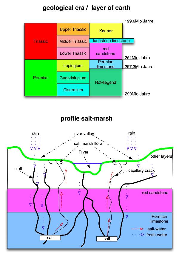
The salt meadows owe their existence to the special geological stratification.
About 230 millions of years ago in a time with tropical climate the sea has withdrawn from this
area and it has left a large salt layer here and there.
The salt layer has become deposited below about
770 yards of red sandstone in a layer of Permian limestone.
Volcanic activity and the ravages of time have caused clefts in the geological layers.
Ground water and rain reaches the Permian limestone through these clefts.
The water dissolves the salts and minerals contained in this layer.
The salt water rises up to the earth´s surface in tiny cracks due to capillar action.
The spots of the saline springs can only be found through looking for the above mentioned
halophytes or in summer when the springs cause green spots on the yellow brownish meadows.
What you need for your log:
From which depth coes the saline water?
How thick is the layer of Permian limestone at most?
Which halophyte found here has something of a fruit in its name?
A picture showing you with the eagle of the springs (a large eagle made from stainless steel stuated nearby)