Hopfenbacheinfall EarthCache
-
Difficulty:
-

-
Terrain:
-

Size:  (other)
Please note Use of geocaching.com services is subject to the terms and conditions
in our disclaimer.
Spaziergang zu einer Bachschwinde im Wald / A walk to a sinkhole in the forest
(English text see below)
 Es ist unklar, ob sich der Name "Hopfenbach" von der in dieser Gegend häufig angebauten Pflanze herleitet oder von dem Wort "hüpfen" bzw. "hopsen". Letzteres würde auf eine Besonderheit hinweisen, die ihr auf der Wiese vor Euch beobachten könnt, wenn ihr an den angegebenen Koordinaten steht.
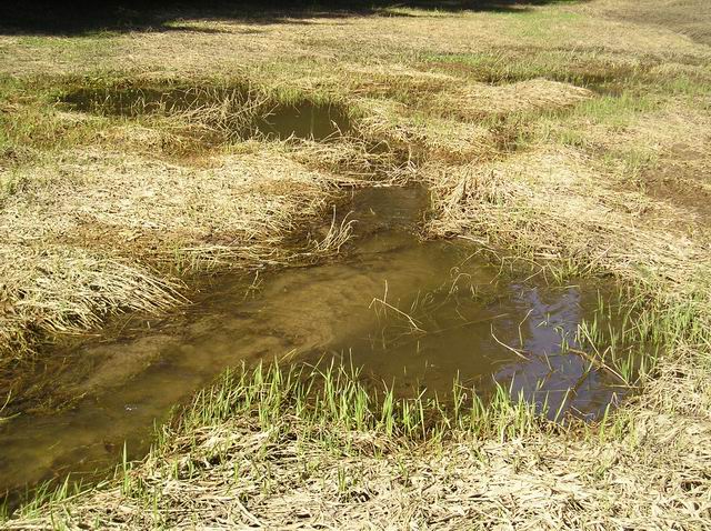
Der Bach, der südöstlich von Bachl entspringt, fließt hier am südlichen Rand der Lichtung aus dem Wald heraus. Einen Abfluss wird man aber auf der Wiese in der Regel nicht finden - der Bach verschwindet hier nämlich im Untergrund. Die genaue Stelle ändert sich ständig - mal versickert das Wasser ganz unspektakulär, mal stürzt es laut rauschend in einen tiefen Trichter. Bei stärkerer Wasserführung staut sich der Bach auch zu einer größeren Seefläche auf. Nur bei sehr starker Wasserführung setzt der Bach seinen Weg oberirdisch durch das sonst trockene Hopfenbachtal fort.
Verantwortlich für dieses Phänomen sind - teilweise mehrere hundert Meter starke - Wechsellagerungen von Malmkalk- und Mergelgesteinsfolgen. Im Laufe der Jahrmillionen verwitterten die Kalke. Es entstanden unterirdische Hohlräume und Wasser führende Risse, durch die der Hopfenbach hier seinen Weg fortsetzt.
Gebiete mit solchen geologischen Strukturen nennt man Karst. Oberirdisch findet man dort oft auch so genannte Dolinen - Krater, die durch Erosionsprozesse verschiedener Art entstanden sind.
Um den Cache loggen zu können, müsst Ihr folgende Bedingungen erfüllen:
- Macht ein Foto von der Wiese, auf der der Hopfenbach versickert. Wenn es die Bodenbeschaffenheit zulässt, sollte man die Versickerungsstelle möglichst gut erkennen können. Damit sollen die Veränderungen an der Location dokumentiert werden.
- Macht ein Foto von Euch und / oder Eurem GPS-Gerät oder einem anderen persönlichen Gegenstand vor der Informationstafel.
Beide Fotos bitte beim Loggen mit hochladen. Bitte beschreibt in Eurem Logeintrag auch das aktuelle Aussehen der Versickerungsstelle und der Wiese.
- Beantwortet folgende Fragen:
a) Vor wie vielen Millionen Jahren entstanden die oben erwähnten Gesteinsfolgen ?
b) In welchem Land / Gebiet wurde das Phänomen "Karst" erstmals beschrieben ?
c) Ein Bild auf der Tafel zeigt ein tiefes Loch, in das sich der Bach an einem bestimmten Tag ergossen hat. Schaut auf das Datum. Was assoziiert Ihr mit diesem Tag ?
d) Welche ungewöhnliche Pflanze kommt auf der Wiese vor, auf der der Hopfenbach verschwindet ?
e) Wie erklärt eine örtliche Sage die Entstehung der Löcher, in denen der Bach verschwindet ?
f) Was befindet sich in unmittelbarer Nähe der Informationstafel (diese Reservefrage muss nur beantwortet werden, falls die Informationstafel vollends zerstört oder abgebaut wird) ?
- Wegkreuz
- Marienstatue
- hölzerner Pilz
- Informationstafel über Waldvögel
Schickt die Lösungen der Fragen a) bis e) bzw. f) an mich. Wenn Ihr Euch sicher seid, die richtigen Antworten zu haben, dann braucht Ihr die Logfreigabe nicht abzuwarten. Sollte ich die richtigen Antworten aber nicht bekommen, wird der Log gelöscht.
Mir ist kein entsprechendes Verbotsschild aufgefallen, aber ich empfehle Euch trotzdem, das Auto bei N 48° 49.709 E 011° 56.111 am Waldrand abzustellen. Von dort aus sind es etwa 1.7 km auf brauchbaren Waldwegen bis zum Cache. Der Weg ist für einigermaßen geländegängige Kinderwagen geeignet.
In unmittelbarer Nähe zu den Parkplatzkoordinaten befindet sich auch eine Haltestelle der VLK-Buslinie 6 (Haltestelle "Großmuß Abzw.").
It is unclarified if the name "Hopfenbach" ("bach" = "creek") is derived from the hop plantations in this area or from the verb "to hop".
The latter would point to a peculiarity which you can see on the meadow in front of you if you are at the listing coordinates.
The creek, which rises south-east of Bachl, leaves the forest at the southern side of the clearing. But usually you won't find any outlet on this meadow - the creek vanishes into the subsoil. The exact place changes constantly. Sometimes the water seeps away unspectaculary, sometimes it falls roaring into a deep sinkhole. In case there is a lot of water, even a small pond can develop. Only if there is a very huge amount of water, it continues its way through the - normally dry - Hopfenbach valley.
The reason for this phenomenon are alternating layers of limestone and marl, which can be hundreds of meters thick. Throughout millions of years, the lime weathered. Subterranean cavities and water-bearing crevices came into being, throughout which the Hopfenbach continues ist way from here.
Areas with such geological structures are called karst. Above ground, you can often see dolines as they are called - craters, formed by erosion processes of different kind.
In order to being allowed to log this cache, you must fulfill the following requirements:
- Take a picture of the meadow on which the Hopfenbach vanishes. If the condition of the ground allows it, the point of seeping-away should be visible on the picture as clear as possible. This is to document the changes at this location.
- Take a picture of you and / or your GPS receiver or another personal item in front of the information board.
Please add both pictures to your log entry. In your log entry, please also describe how the point of seeping-away and the meadow did look when you were there.
Answer the following questions:
a) How many million years ago the rock layers mentioned above formed ?
b) In which country / area the karst phenomenon was desribed for the first time ?
c) A picture on the board shows a deep hole into which the creek poured on a special day. Look on the date. What happened on this day ?
d) Which unusual plant is growing on the meadow where the Hopfenbach vanishes ?
e) What ist the origin of the holes, in which the creek vanishes, according to a local legend ?
f) What can you see close to the information board (you must answer this backup question only in case the board is completely destroyed or removed or if your German is not good enough to understand the text on the board) ?
- wayside cross
- statue of the Virgin Mary
- wooden mushroom
- information board about forest birds
Send the answers to those questions to me. If you are sure that your answers are right, you don't need to wait for my log permission. But in case I do not receive the right answers, I will delete the log entry.
I did'nt see a prohibition sign, but I recommend you to park your car at N 48° 49.709 E 011° 56.111 at the edge of the forest. From there to the cache location, you have to walk about 1.7 kilometers on useable forest trails. The trails are suitable for strollers if they are somewhat cross-country qualified.
Close to the parking location, there is a bus stop of the VLK bus line 6 (the name of the bus stop is "Großmuß Abzw.").
Additional Hints
(No hints available.)