| This cache is part of the Seven Wonders of Pike County, a project developed by a team of teachers with the support of the Pike County Conservation District, dedicated to the preservation and appreciation of the great natural and historical sites in Pike County, PA, through education and recreation. There is a limited-time prize available to those who complete all of the Seven Wonders, described on the project's web page. |
Dingmans Falls is located within the boundaries of the Delaware Water Gap National Recreation Area. It is in Pike County, Northeast Pennsylvania, at the village of Dingmans Ferry, on U.S. Route 209. A half-mile loop trail follows the hemlock-shaded Dingmans Creek.
Dingmans Falls is within the Glaciated Low Plateau Section of the Appalachian Plateaus Physiographic Province. The bedrock exposed at Dingmans Falls is Devonian in age, 365-405 million years old, and is made up of sedimentary rocks such as red and gray sandstone, siltstone, and gray shale.

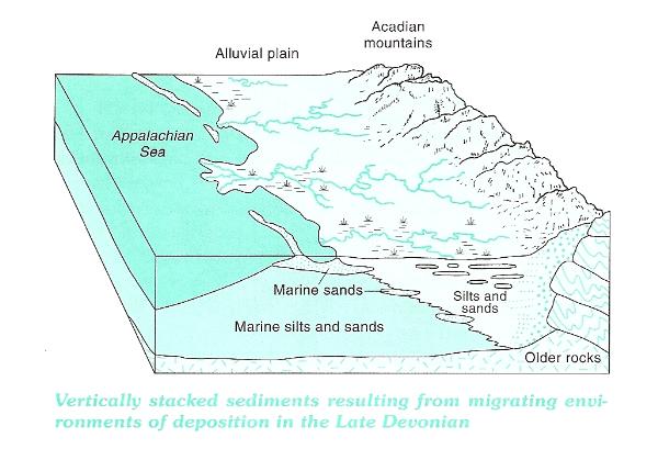
These rocks represent sediment that was originally deposited by streams in or near an ancient sea. The mountains that provided these sediments, the Acadian Mountains, formed by intense pressure from an earlier collision between the North American and African continental plates, and were located southeast of this ancient sea. Sediments, eroded from these mountains over millions of years, was carried by streams, and deposited, both on the sea bottom as well as along its shoreline. This environment would be similar to the present Mississippi Delta and the Gulf of Mexico. The bedrock at Dingmans Falls, part of what is known as the Catskill Formation, represents the sediments deposited both on the sea bottom and on the alluvial plain between the Appalachian Sea and the Acadian mountains.
The sediments that were deposited during the Devonian were eventually compacted and cemented into the rock we see today. Another orogeny (mountain building episode), called the Alleghanian Orogeny folded and uplifted part of the old Appalachian sea basin approximately 270-280 million years ago. This event, caused by a stronger collision between the North American and African continental plates, at the end of the Paleozoic Era, produced the Appalachian Mountains and the Appalachian Plateau that includes the Pocono Plateau on the eastern edge. Weathering and erosion of the weaker rock, especially the rock that had been folded, has been shaping the rock of Eastern Pennsylvania since that time.
The steep escarpment that faces the Delaware River in this area of Pike County marks the edge of the Pocono Plateau. This drop, of about 1000 feet, to the Delaware River creates conditions for a number of scenic waterfalls such as Dingmans Falls at this location. The falls have cut into the plateau, forming deep gorges and ravines that have exposed the sandstone, siltstone, and shale that developed during the Devonian. These deep hemlock and white pine shaded ravines create low-light, high-humidity microclimates that support a variety of non-flowering plants.
The boardwalk trail at the Dingmans Falls ravine, leads first to the 80-foot Silver Thread Falls. Silver Thread Falls flows through a narrow joint fracture in the weak shale sedimentary rock. The path then leads to magnificent Dingmans Falls, one of the highest falls in Pennsylvania, which cascades 130 feet, over flat-lying stair step layers of Mahantango shale. At the base of Dingmans Falls, you can climb a steep staircase of 240 steps to the top of the falls.
Another interesting Earth Science topic to consider while at Dingmans Falls is stream gradient. Gradient is the slope of the stream channel, expressed as the vertical drop of a stream over a specified distance. To calculate gradient, divide the number of feet in elevation change by the number of miles between the two points (straight-line distance); it is very typical to express this in feet/mile. Gradient is important since the ability of a stream to erode and transport materials depends on its velocity. Steeper gradients will have a greater velocity. That helps to explain how Dingmans Creek has been able to erode its channel through the Devonian age rocks. In addition, glaciers covered this area 15,000 years ago. Additional meltwater, carrying sediment particles from the retreating glaciers flowing through these streams like Dingmans Creek, provided additional erosional power to help carve the waterfalls and ravines of Pike County.
The large evergreen trees of the ravine are Eastern hemlocks (Tsuga canadensis), the state tree of Pennsylvania. An insect from Asia, the hemlock woolly adelgid, is threatening Eastern hemlock trees in North America. Infestation greatly weakens and often kills hemlocks. The future of Eastern hemlocks in Delaware Water Gap National Recreation Area is not certain. Resource specialists are monitoring the presence of hemlock woolly adelgid in the recreation area. You may notice, as you walk the trail, the blue metal tags attached to the base of some hemlocks. Some trees are being treated to try to control the damage caused by this invasive species.
The posted coordinates for this earthcache are for the main parking lot at Dingmans Falls and several waypoints along the trail. The completion of this earthcache involves a hike that takes you to several geologically interesting features located along the trail of Dingmans Falls. In order to get credit for the completion of this earthcache, send the answers to the following questions to me (CaptainMath) through the geocaching messenger feature, or email them to me at captainmath05@gmail.com
- Identify the sedimentary rock feature that controls the shape of the water channel at Silver Thread Falls.
- Post a photo of yourself and/or your GPSr on the walkway near N41 13.812 W74 53.244 with Silver Thread Falls in the background.
- Continue on up the trail to Dingmans Falls. Calculate the gradient of Dingmans Falls, from the top of the falls at the highest extent of the trail down to the base of the falls. Express your answer in ft/mile.
- Based on your hike of the Dingmans Falls Ravine, and your observations of both Silver Thread Falls and Dingmans Falls, do you believe that the source of their water is the same? What did you observe that led you to that conclusion?
- BONUS (not required for completion of this earthcache): If you've also completed the Earthcache at Childs Park, calculate the gradient of Dingmans Creek from Factory Falls to the base of Dingmans Falls. Since these two Earthcaches give you two different readings on Dingmans Creek, you'll have an interesting overall profile related to water erosion along this stream.