Earthcache Klingender Wasserfall EarthCache
Earthcache Klingender Wasserfall
-
Difficulty:
-

-
Terrain:
-

Size:  (other)
Please note Use of geocaching.com services is subject to the terms and conditions
in our disclaimer.
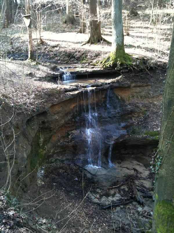
Klingender Wasserfall
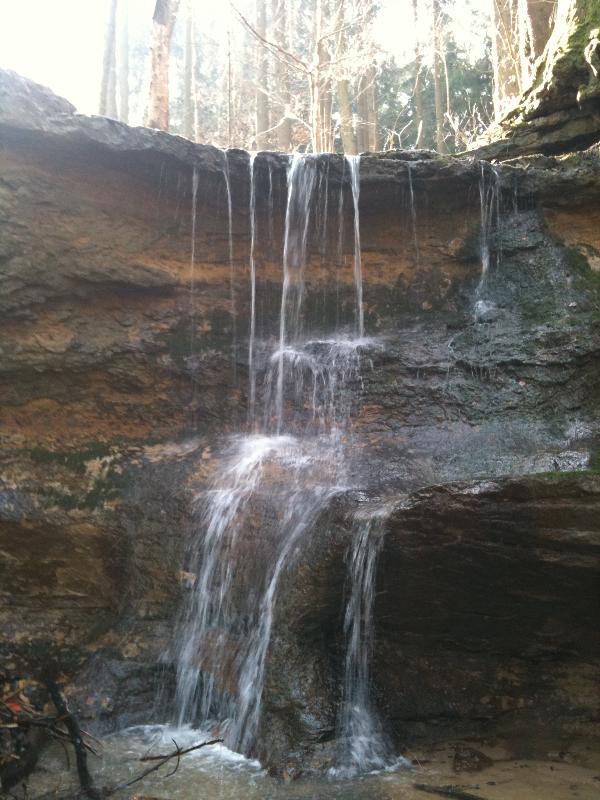
Am Klingenden Wasserfall sind die Rhaetolias - Übergangsschichten hervorragend aufgeschlossen. Die harten Sandsteine bilden eine Schichtstufe, an deren Rand der Wasserfall liegt.
Geologie: Arieten Schichten (Lias Alpha 3)
Rhaeto-Lias-Übergangsschichten (Oberer Keuper)
Keuper:
Der Keuper ist die oberste der drei lithostratigraphischen Gruppen der Germanischen Trias. Diese Dreiteilung, die namensgebend für das chronostratigraphische System Trias war, gilt aber nur für den Bereich nördlich der Alpen (Germanische Trias-Supergruppe). Der Keuper wird in etwa auf den Zeitraum von 235 bis 201 Millionen Jahre datiert. Er folgt auf die lithostratigraphische Gruppe des Muschelkalks und wird von der lithostratigraphischen Gruppe des Lias (Norddeutschland) bzw. des Schwarzen Jura (Süddeutschland) überlagert.
Buntsandstein und Muschelkalk waren bereits zum Ende des 18. Jahrhunderts fest etablierte Gesteinseinheiten. Dagegen dauerte es beim Keuper bis in die 1820er Jahre bis er als eigenständige Gesteinseinheit erkannt wurde. Bis zu diesem Zeitpunkt wurde er meist als Teil des Buntsandsteins angesehen. Der Begriff Keuper wurde von Leopold von Buch in die geowissenschaftliche Literatur eingeführt. Allerdings gebrauchte er den Begriff im Sinne eines Gesteinsnamens, nicht im Sinne einer lithostratigraphischen Einheit. Der Name „Keuper“ leitet sich von der fränkischen Dialektbezeichnung „Kiefer, Kieber oder Keiper/Keuper“ für bunte, bröckelige Tongesteine ab. Die Übertragung dieses Begriffes auf die Gesteinseinheit geht auf Friedrich Hoffmann zurück, der ihn 1823 in mündlicher Form in diesem Sinne gebrauchte. Vermutlich unabhängig von ihm tat dies auch Christian Keferstein und so müssen wohl diese beiden Geologen als Urheber der Gesteinseinheit Keuper gelten.
Die Untergrenze des Keuper wird in Norddeutschland mit der Unterkante des sog. Unteren Lettenkohlensandsteins definiert. In Süddeutschland ist die Untergrenze die Basis des „Grenzbonebeds“. Die Obergrenze ist die Basis des Lias in Norddeutschland bzw. des Schwarzen Jura in Süddeutschland. Die Typregion ist Franken. Im Norddeutschen Becken werden durchschnittliche Mächtigkeiten zwischen 300 und 500 Metern erreicht, lokal bis 1000 Metern. Im Glückstadt-Graben lassen seismische Untersuchungen auf eine Mächtigkeit bis 5000 Meter schließen. Es handelt sich um marin beeinflusste Kalk- und Tonsteine, lakustrine Kalk- und Tonsteine, fluviatile und litorale Sand- und Siltsteine, fossile Böden und Wurzelhorizonte und mächtige Salinarfolgen, wobei im Beckenzentrum in Norddeutschland Steinsalz, in den randlicheren Bereichen Anhydrit (CaSO4) und Gips (Ca[SO4] • 2 H2O) abgelagert wurden.
Oberer Keuper:
Der Obere Keuper beinhaltet dunkle Ton- und Sandsteine, die in einem deltaischen Milieu abgelagert wurden. Darüber folgen marine und wiederum deltaisch geprägte Sandsteine. Am Top der Einheit wurden wiederum limnisch-deltaische Sandsteine abgelagert. Er wird von der Psilonotenton-Formation (Unterjura) überlagert.
Ein großer Dank geht auch an den Owner von dem Cache am Klingenden Wasserfall, der uns die Erlaubnis gab trotz seines Tradis an diesem Platz einen Earthcache zu legen.
Der Earthcache lässt sich wunderbar mit den anderen 3 Caches verbinden:
Klingender Wasserfall GC1NPX1
Am Wegesrand GC1NPZ8
Sprosselbrunnen GC1NPYH
Logbedinung:
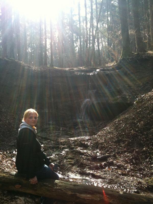
Macht ein Bild von eurem GPS auf dem ihr und der Wasserfall zu sehen seid. Geht zu dem Wegweiser und beantwortet mir folgende Fragen:
Welche Nummer hat die Tafel?
(Antwort =xxxx)
Auf welcher Standort Höhe befindet ihr Euch?
(NN). (Antwort = yyy)
Loggen könnt ihr sofort, sollte etwas nicht in Ordnung sein, werde ich mich melden. Schickt eure Antwort an: kermangc@gmail.com
Wir wünschen euch viel Spaß bei der kleinen Runde, genießt die Ruhe und die Natur und lauscht dem plätschern des Wasserfalls.
 Kid Friendly Kid Friendly  Dogs Allowed Dogs Allowed
 Available year-round Available year-round  Hunting in area - use caution Hunting in area - use caution  Accessible in Winter Accessible in Winter
 Scenic View Scenic View  Mud! Mud!  Ticks Ticks |
|
|

English Description
Klingender Wasserfall
In the sounding waterfall the Rhaetolias - transitional layers are very well open. The hard sandstones form a layer step with whose edge the waterfall lies.
Geology: Arieten layers (Lias alpha 3)
Rhaeto Lias-transitional layers (of upper Keuper)
Keuper:
The Keuper is the uppermost one of three lithostratigraphischen groups the Germanic Trias. However, this trisection which was a Trias name-giving for the chronostratigraphische system is valid only for the area to the north of the Alps (Germanic Trias-supergroup). The Keuper is dated in possibly for the period of from 235 to 201 million years. He follows the lithostratigraphische group of the mussel lime and is overlaid by the lithostratigraphischen group of the Lias (North Germany) or the black law (South Germany).
New red sandstone and mussel lime were already at the end of the 18th century firmly established rock unities. Against it it lasted with the Keuper till the 1820s to him as an independent rock unity was recognised. Up to this time he was mostly looked as a part of the new red sandstone. The concept Keuper was introduced by Leopold von Buch in the geoscientific literature. Indeed, he did not use the concept for the purposes of a rock name, for the purposes of a lithostratigraphischen unity. The name "Keuper" is derived from the Frankish dialect name „Pine, Kieber or captain of a fishing boat / Keuper“ for coloured, crumblike sound rocks. The transference of this concept to the rock unity decreases to Friedrich Hoffmann who used him in 1823 in verbal form in this sense. Presumably regardless of him this also did Christian Keferstein and thus these both geologists must be probably valid as an originator of the rock unity Keuper.
The lower limit of the Keuper is defined in North Germany with the lower edge of the so-called lower Latvian's coal sandstone. In South Germany the lower limit is the base of the "Grenzbonebeds". The upper limit is the base of the Lias in North Germany or the black law in South Germany. The type region is Franconia. In the North German washbasin average thickness is reached between 300 and 500 metres, locally to 1000 metres. In the luck town ditch seismic investigations conclude by a thickness to 5000 metres. It concerns marine influenced limestone and sound stones, lakustrine limestone and sound stones, fluviatile and litorale sand and Siltsteine, fossil grounds and root horizons and mighty Salinarfolgen and in the pelvic centre in North Germany stone salt, in the randlicheren areas Anhydrit (CaSO4) and gypsum (Approx. [SO4] 2 H2O) were deposited.
Upper Keuper:
The upper Keuper contain dark sound stones and sandstones which were deposited in a deltaischen environment. About that follow marine and again deltaisch stamped sandstones. In the top of the unity limnisch-deltaische sandstones were deposited again. He is overlaid by the Psilonotenton formation (unterlaw).
Big thanks also go in the Owner of the Cache in the sounding waterfall which gave to us the permission in spite of his Tradis on this place to lay an Earthcache.
The Earthcache wonderfully joins with other 3 Caches:
Klingender Wasserfall GC1NPX1
Am Wegesrand GC1NPZ8
Sprosselbrunnen GC1NPYH
Logpermission:
Take a picture of You and your GPS on the waterfall . Go to the signpost and answers to me the following question:
Which number has the board?
(Answer =xxxx)
On which location height are you?
(NN). (Answer = yyy)
Please, log it and send your answers to my account: kermangc@gmail.com
We wish you a lot of fun with the small round, the rest and the nature enjoys and listens in to him splash of the waterfall.
Quelle: Wikipedia
19.10.2019 - autoresponder entfernt
Additional Hints
(No hints available.)