Lärjeån - meandering stream EarthCache
Lärjeån - meandering stream
-
Difficulty:
-

-
Terrain:
-

Size:  (not chosen)
Please note Use of geocaching.com services is subject to the terms and conditions
in our disclaimer.
Det finns ingen behållare eller log bok vid en earth
cache. Istället LÄS TEXTEN NEDAN.
Parkering vid informationstavla : N57 48.697 E12 10.596. Buss 520
stannar alldeles intill vid Bergums Kyrka !!
There is no box and no log book at an Earth cache. Instead read the
TEXT BELOW !
Parking at the info board : N57 48.697 E12 10.596. Bus 520 stops
just nearby at Bergums Kyrka !!
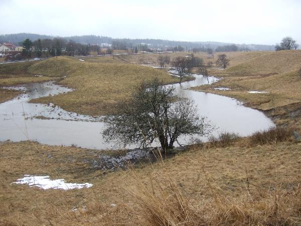
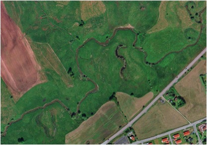
Lärjeån norr om RV190 och sedd
ovanifrån. Notera särskilt korvsjöarna !
Lärjeån north of road 190 and seen from above. Notice
the oxbow lakes !
[SWE]
Landskapet där den lilla ån
Lärjeån flyter fram i den form som vi ser idag skapades
huvudsakligen efter den senaste istiden för 12000 år
sedan.
Det finns en stor mångfald av olika landskap utmed ån
från mycket vindlande partier till djupa raviner. Innan
ån når sitt slutmål finns även en serie
mycket vackra vattenfall.
En gång startade ån vid sydändan av sjön
Mjörn men stora moränbankar med grus och sand byggdes upp
av inlandsisen när den drog sig tillbaka. Sjöns utlopp
kom därvid att blockeras och Lärjeån reducerades
från en bred älv till den smala ström vi ser
där idag. Därav är inte Mjörn längre
huvudkällan för Lärjeån utan sjön
avvatnas genom Säveån som genom kraftverksreglering
håller sjön på en konstant nivå.
Den breda floddalen blev nästan helt uttorkad och den nu smala
ån började gräva sig ner i de mjuka sedimenten
vilket skapade erosion men också djupa raviner med
rasbranter. Dessa rasbranter bryts ner och faller än idag
ibland ner i ån.
Geologiskt sett är dalen kring Lärjeån en
sprickdal.
Det finns två geologiskt sett intressanta fenomen som
hör ihop med en långsamtflytande å i
slättlandskap som kallas meandrar och korvsjöar. Ordet
meander kommer från antikens Grekland och var synonym med en
vindlande flod som hette Maiandros. Denna flod ligger idag I
Turkiet söder om Izmir.
Det finns olika teorier kring hur meandrar bildas.
En av dessa säger att det sker genom erosion och sedimentering
i relativt plana partier där mycket partikel och lerhaltigt
vatten rinner. När vatten rinner i en böj så
tenderar vattnet att gräva ut material i ytterkurvorna
eftersom strömmen är starkast där varvid
åkanten eroderas. I innerkurvan där hastigheten är
lägre sedimenterar istället material som ån
bär med sig. Med tiden kommer ån att röra sig inte
längs en rak bana utan längs en sinusformad vågform
sett ifrån ovan. Allteftersom åns volymflöde
ändras över tiden kommer överhängande och
underskurna avsnitt att bildas i åböjarna och
därmed ändra formen på åkanterna. Olika
hårda material i åns väg och olika friktion utmed
bottnen tillsammans med föränderliga volymflöden
kommer att leda till att nya fåror eroderas fram. De
äldsta delarna av ett meandrande flodsystem uppvisar ofta
korvsjöar vilka har uppstått när ån
grävt sig fram som genvägar mellan åns olika delar.
Sedimenterad jord blockerar tillgången till de avskurna
böjarna och de finns kvar som böjar utan förbindelse
med huvudfåran.
En annan intressant aspekt på meandrar är att vattnet
har en varierande syrehalt på grund av åns olika
hastigheter i meandrarna.
Lärjeån har en mycket omväxlande och rikhaltig
flora utmed sina bankar och I de mer strömmande partierna
finns även fisk. Ån växer kraftigt till sig
när många bäckar som avvattnar skogsmarkerna intill
rinner in i den.
Uppgifter :
*Tag en väl synlig bild av dig själv och din GPS vid de
angivna koordinaterna med en likaså fullt synlig korvsjö
bakom dig. Publicera den tillsammans med din logg. Enligt
regelverket numera är detta en option. Jag ser gärna att
du tar fotot men om du av någon anledning inte vill/kan detta
ber jag dig besvara denna fråga istället tillsammans med
övriga nedan :
Vilka siffror står det på metallskylten på
lyktstolpen nära angivna koordinater till ingången
?
Besvara sedan även följande 3 frågor med epost
direkt till cache ägaren :
* Beskriv namnet på 2 andra teorier om hur en meandrande flod
kan tänkas uppkomma ?
* Beräkna ett närmevärde på meanderkvoten
för Lärjeån ? Motivera !
* Var startar resp slutar Lärjeåns flöde ? (Ange
namn på vatten och inte koordinater.)
Vänligen notera :
att det inte är tillåtet att publicera svar eller
anvisningar till svar i din logg. Loggar som innehåller denna
information kommer att raderas.
Notera även att det inte är tillåtet att logga
found innan rätt svar på frågorna har
bekräftats av cache ägaren. Skriv en note som en
platshållare och ändra den sedan till en found när
du fått dina svar godkända !
Found utan godkänt svar kommer att raderas.
Parkering vid informationstavla : N57 48.697 E12 10.596. Grind
vid N57 48.567 E12 10.319. Varning, el staket aktivt om djuren
betar ute !! Gummistövlar kan vara bra vid regnigt väder
!!
Lycka till och njut av naturen !
Ingabo
[ENG]
The landscape where the small stream Lärjeån flows in
the shape seen today was mainly created after the last ice age
12000 years back in time. There is a hugh variety of different
landscapes along the stream from very winding parts to deep canyons
as the stream makes its way. Before the stream reaches its final
destination there are also a series of beautiful rapids.
Once starting at the southern end of lake Mjörn huge gravel
and sand reservoirs were built up as the ice moved away. These
sandbanks then blocked the water outlet from the lake to the stream
reducing its size from a main waterway to a minor stream as it is
today.Thus the lake Mjörn is not longer the major water source
for the stream instead the lake uses the river Säveån to
keep its water level constant.
The wide valley went almost dry and the now narrow
Lärjeån started to carve its way down the soft sediments
causing heavy erosion and also forming canyons with weak riversides
on its way. These steep riverbanks now and then break and slide
down into the stream.
Geologically seen the valley around Lärjeån is a fissure
valley positioned in an east west direction.
There are two geological interesting phenomenas associated with a
stream in flat low lands called meanders and oxbow lakes.
The term meander is derived from ancient Greece where it was
synonym with a winding river named Maiandros. This river is
situated in present day Turkey, south of Izmir.
There are different theories on how meanders are formed. One says
it happens by erosion and deposition in fairly flat sections of
rivers where there is a lot of silt-filled water flowing. As the
water flows around a bend, the river tends to dig out material of
the curve because the stream is strongest on the outer part of the
curve where then maximum erosion takes place. In the inner bend
there is then often deposition of material carried by the
stream.
Over time a sinus wavelike shape will characterize the stream flow
when seen from above. As the stream changes its volume flow over
time overhanging and undercut bend areas will continuously change
the shape of the riverbanks. Different hard materials in its way
and different bottom friction materials together with changing
volume flow will erode a new path for the stream to follow.
The oldest parts of a changing meandering stream often shows so
called oxbow lakes due to cut offs made after periods with very
strong meandering. Where the water flow is more sluggish deposition
of material occurs more than erosion. The gravel and silt left
behind block off the old meander as a curved lake.
Another interesting aspect of meanders is the varying oxygen
content in the water due to the velocity differences in the stream.
A very rich flora is found along the stream Lärjeån as
well as fish further downstreams. The stream grows rapidly in
volume as several streams from the nearby woods flow into it and
also after rain the level changes rapidly.
Tasks :
*Take a clearly visible picture of yourself and your GPS at the
coordinates given with a full oxbow lake well visible behind you.
Publish it together with your log. According to the current rules
this should be an option. I would appreciate if you take the
picture unless you by some reason do not want to or can do so. If
that is the case I want you to prove your presence at site by
answering an optional question and also send this answer together
with the other 3 questions listed below :
What number is found on the light pole close to the given entrance
coordinates ?
Answer also the following 3 questions with email directly to the
cache owner together with your email address :
* Name 2 other different theories on how a meandering river can be
created.
* Calculate a value of the meander ratio for Lärjeån.
Motivate.
* Where is the geographical (water names not coordinates) starting
and ending point of Lärjeån ?
Please note that you may not publish any answers or hints in
your log. Doing so will cause the log to be deleted. It is also not
allowed to log a found before a correct answer to the questions is
confirmed by the cache owner. Write instead a note as a placeholder
and change it to a found when your answers are approved ! Found
logs without approved answers will be deleted !
Parking at the info board : N57 48.697 E12 10.596. Enter gate at
N57 48.567 E12 10.319. Warning, electric fence active if cattle is
out. Wellingtons may be needed if rainy weather !!
Good Luck and enjoy the scenery !
Ingabo
Additional Hints
(No hints available.)