| This cache is part of the Seven Wonders of Pike County, a project developed by a team of teachers with the support of the Pike County Conservation District, dedicated to the preservation and appreciation of the great natural and historical sites in Pike County, PA, through education and recreation. There is a limited-time prize available to those who complete all of the Seven Wonders, described on the project's web page. |
Childs Park is located within the boundaries of the Delaware Water Gap National Recreation Area. It is in Pike County, Northeast Pennsylvania, three miles west of the village of Dingmans Ferry, along Silver Lake Road. A two-mile trail circles three cascades in Dingman’s Creek. Wooden bridges, boardwalks, and stairs are found along the Hemlock shaded trail.
Childs Park is within the Glaciated Low Plateau Section of the Appalachian Plateaus Physiographic Province. The bedrock exposed at Childs Park is Devonian in age, 365-405 million years old, and is made up of sedimentary rocks such as red and gray sandstone, siltstone, and gray shale.

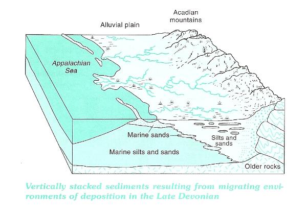
These rocks represent sediment that was originally deposited by streams in or near an ancient sea. The mountains that provided these sediments, the Acadian Mountains, formed by intense pressure from an earlier collision between the North American and African continental plates, and were located southeast of this ancient sea. Sediments, eroded from these mountains over millions of years, was carried by streams, and deposited, both on the sea bottom as well as along its shoreline. This environment would be similar to the present Mississippi Delta and the Gulf of Mexico. The bedrock at Childs Park, part of what is known as the Catskill Formation, represents the sediments that were deposited on the alluvial plain between the Appalachian Sea and the Acadian mountains.
There are several clues within the rocks at Childs Park that tell us a little about the environment in which the sediments were deposited, and are features only found in sedimentary rocks. First, the rocks are composed mainly of sand grains that have been cemented together into sandstone. Secondly, some angled curved layers (crossbeds) are tilted in many different directions. In addition, a sedimentary structure, ripples or ripple marks are exposed in some of the rocks along Dingman's Creek.

The crossbeds form a definite pattern that is repeated many times. That pattern is a series of small troughs, which is called trough crossbedding. Comparisons of the sediment size, along with the trough crossbedding, to alluvial sediments that are being deposited today, indicate that these features are most common in braided rivers.

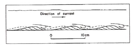
In addition to the crossbedding, sedimentary structures commonly called ripple marks can be seen on the rocks at several locations within the park. Ripple marks are small waves on the surface of sediment, and eventually preserved in the rock, caused by water or wind currents. Ripple marks are a telling sign of the ancient environment that formed the rocks in which they appear. There are wave-formed ripple marks and current ripple marks. They can be distinguished from each other by careful examination. Wave-formed ripple marks are generally symmetric (top diagram) whereas current ripple marks are asymmetric (bottom diagram). The asymmetric ripple marks can be used to indicate current direction and are formed in soft sediments within a stream channel.

Another interesting Earth Science topic to consider while at Childs Park is stream gradient. Gradient is the slope of the stream channel expressed as the vertical drop of a stream from one location to another, divided by the horizontal distance between those two points. It is usually expressed in units of ft/mile. The ability of a stream to erode and transport materials depends on its velocity. Steeper gradients will have a greater velocity. That helps to explain how Dingman's Creek has been able to erode its channel through the Devonian age rock.
The posted coordinates for this earthcache are for the main parking lot at Childs Park and several waypoints along the trail. The completion of this earthcache involves a hike that takes you to several geologically interesting features located along the trail of Childs Park. In order to get credit for the completion of this earthcache, you must email the answers to the following questions to 7wondersofpikecounty@gmail.com:
- Hike the trail upstream along Dingman's Creek to the posted coordinates which take you to the Fulmer Falls sign. Here you'll find a large rock outcrop where the sedimentary rock feature, crossbedding, can clearly be seen. Post a photo of yourself and/or your GPS with the outcrop in the background.
- Proceed on the trail to N 41° 14.260 W 074° 54.988. What sedimentary rock feature can be seen in the rocks at this location? Identify whether these features were formed in an ocean or a river and justify your choice using the information given above.
- Continue on up the trail to a large, stone structure, in remarkably good shape for its age, built for an interesting purpose. "Bonus points" go to the first cacher who can identify its original purpose (not required for completion of the Earthcache.)
- Continuing a very short distance past the stone structure, you'll see a sign with the words "Dingmans Creek" less than 250 feet from the stone structure. Stand on the bridge near that sign and take a reading on the bridge, storing the coordinates and elevation. Now, walk the trail downstream, all the way to the bottom past the bottom of Deer Leap Falls, and stand on the bridge you'll see at that bottom level. Take another waypoint reading there, and find the straight-line distance from the upper bridge and the elevation drop. Calculate the gradient of Dingman's Creek between these two points, expressing your result in ft/mile.