English version below
En geología, una falla es una fractura del plano de la roca, en la cual el material de un lado de la fractura se ha movido con respecto al del otro lado. Las grandes fallas de la corteza terrestre son el resultado de movimientos continuos o secos; y zonas de fallas activas son el epicentro habitual de la mayoría de los terremotos. Los terremotos están causados por la liberación de la energía en un rápido desplazamiento a lo largo de la falla. La línea de falla es el trazo de superficie de la falla: la línea de intersección entre el plano de falla y la superficie de la Tierra. Ya que las fallas no suelen consistir en fracturas limpias y simples, el término "zona de falla" se usa para referirse a la zona de deformación compleja que está asociada al plano de la falla.
Mecanismos
La creación y el comportamiento de las fallas, tanto en una individual como en zonas de mayor extensión que definen las placas tectónicas, está controlada por el relativo movimiento de los bloques, tanto en cada lado como en la superficie de la falla. Debido a la fricción y a la rigidez de sus materiales, las rocas no pueden sencillamente deslizarse por encima las unas de las otras. Cuando la roca llega a un punto que sobrepasa su umbral de tensión, la misma se libera como energía y se transmite a través del plano donde la falla está asentada. La tensión tanto acumulada como instantánea depende de la capacidad de deformación y esfuerzo de los materiales de la roca, la parte baja de la corteza y el manto acumulan la deformación gradualmente por medio de plegamientos, mientras que la corteza superior reacciona fraccionándose o liberando instantáneamente la presión causando un movimiento a través de la falla. Una falla en rocas dúctiles puede también liberar la energía cuando el grado de tensión es demasiado alto. La energía liberada de forma rápida es la causa de terremotos, un fenómeno común a lo largo de los límites de las placas tectónicas.
Tipos de fallas
 Las fallas se pueden clasificar principalmente en cuatro tipos en función de los esfuerzos que las originan y de los movimientos relativos de los bloques:
- Falla inversa (a): este tipo de fallas se genera por compresión. El movimiento es preferentemente vertical. El labio levantado se eleva sobre el labio hundido.
- Falla normal (b): este tipo de fallas se generan por tracción. El movimiento es predominantemente vertical respecto al plano de falla. El bloque que se desliza hacia abajo es el labio levantado -
- Falla de desgarre o transversal (c): estas fallas son verticales, y el movimiento de los bloques es horizontal. Estas fallas son típicas de límites transformantes de placas tectónicas.
- Falla oblicua: es aquella que presenta movimiento en una componente vertical y una componente horizontal.
Para realizar estas distinciones, se considera la orientación neta del desplazamiento, no la orientación presente, ya que se puede haber visto alterada por fenómenos geológicos locales.
El caché
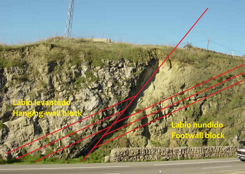
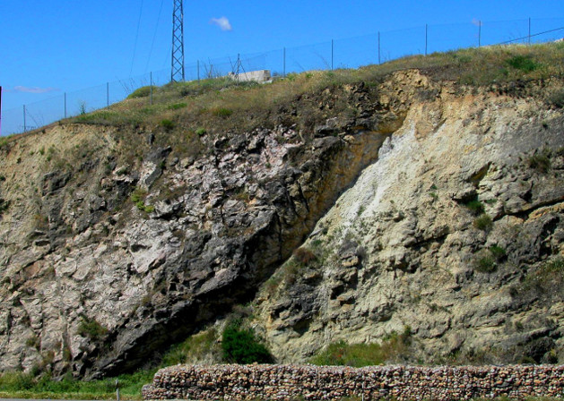
El lugar al que os traemos es un digno ejemplo de falla que podemos encontrar en la localidad de El Molar: concretamente en el kilómetro 41.800 de la carretera A-1, sentido Madrid. Sin embargo, para poder situaros en el lugar correcto para observarla, debéis hacer lo siguiente: cuando os acerquéis por esa carretera hacia El Molar dirección Burgos, debéis coger un camino que sale por del carril de vehículos lentos, poco después de dejar la gasolinera. Las coordenadas que proponemos para aparcar son: N 40º 43.549' W 3º 34.717'… desde aquí os podréis acercar dando un paseo.
Para apuntaros como encontrado este earthcache, debéis hacer lo siguiente: en primer lugar, tomaros una foto con vuestro GPS en la mano en la situación que marcan las coordenadas y la falla al fondo: subid esa foto a vuestro log (la foto no es requisito indispensable). Por otra parte, enviadnos un mail con la respuesta a las siguientes preguntas:
1- ¿qué longitud tiene la línea de falla que podéis observar?
2- ¿Qué tipo de falla es la que estás observando?
Logs que no cumplan con los requisitos serán borrados sin dar explicación alguna
English
In geology, a fault is a planar fracture in rock in which the rock on one side of the fracture has moved with respect to the rock on the other side. Large faults within the Earth's crust are the result of differential or shear motion and active fault zones are the causal locations of most earthquakes. Earthquakes are caused by energy release during rapid slippage along a fault. A fault line is the surface trace of a fault, the line of intersection between the fault plane and the Earth's surface. Since faults do not usually consist of a single, clean fracture, the term fault zone is used when referring to the zone of complex deformation that is associated with the fault plane. The two sides of a non-vertical fault are called the hanging wall and footwall. By definition, the hanging wall occurs above the fault and the footwall occurs below the fault. This terminology comes from mining. When working a tabular ore body, the miner stood with the footwall under his feet and with the hanging wall hanging above him.
Mechanics
The creation and behavior of faults, in both an individual small fault and within the greater fault zones which define the tectonic plates, is controlled by the relative motion of rocks on either side of the fault surface. Because of friction and the rigidity of the rock, the rocks cannot simply glide or flow past each other. Rather, stress builds up in rocks and when it reaches a level that exceeds the strain threshold, the accumulated potential energy is released as strain, which is focused into a plane along which relative motion is accommodated - the fault. Strain is both accumulative and instantaneous depending on the rheology of the rock; the ductile lower crust and mantle accumulates deformation gradually via shearing, whereas the brittle upper crust reacts by fracture, or instantaneous stress release to cause motion along the fault. A fault in ductile rocks can also release instantaneously when the strain rate is too great. The energy released by instantaneous strain release is the cause of earthquakes, a common phenomenon along transform boundaries..
Fault types
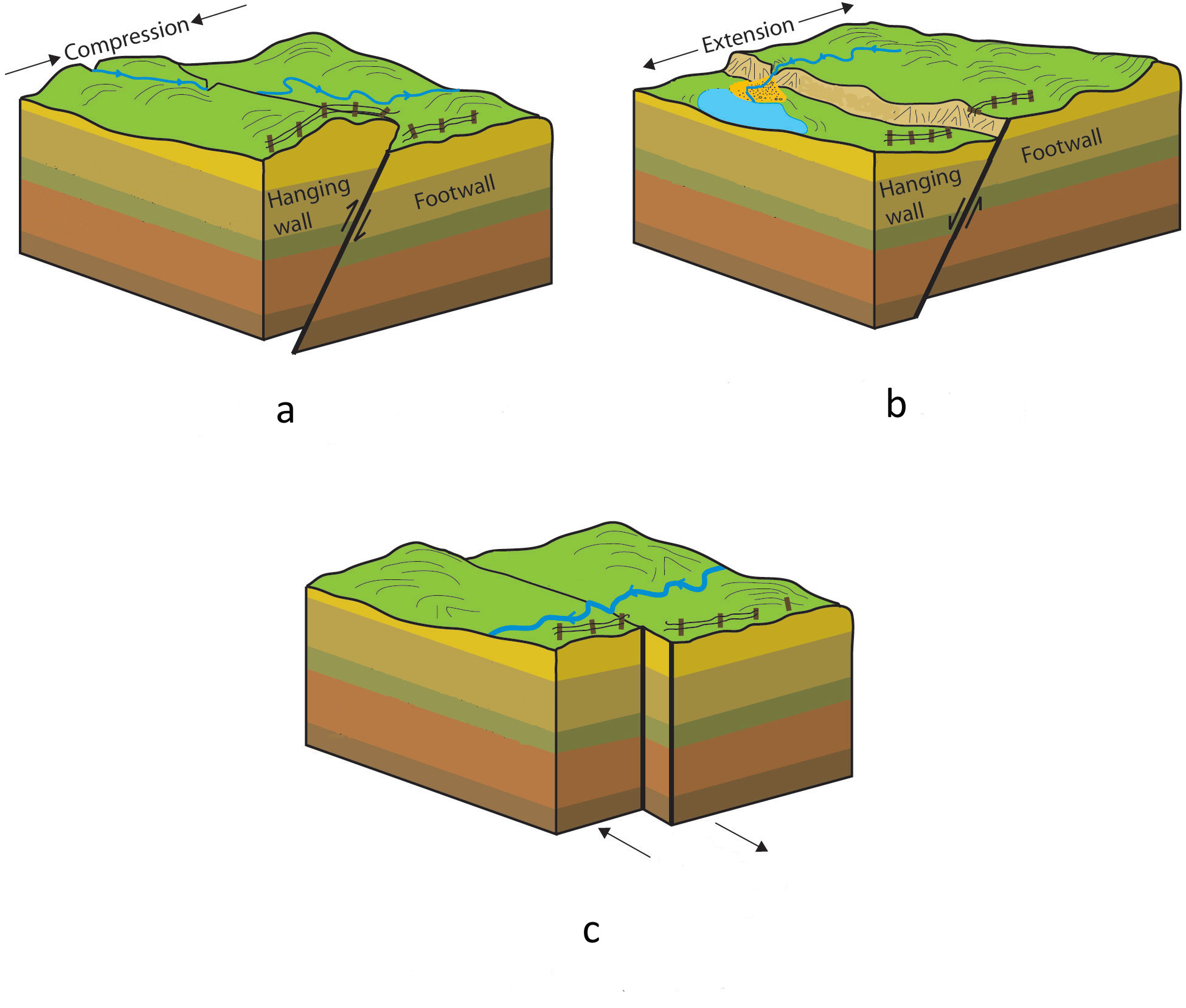 Faults can be categorized into four groups based on the strain that caused them and in the movements of the component blocks:
- Reverse faults (a): they are generated by stain. The movement is mainly vertical. The hanging wall is over the footwall.
- Normal faults (b): they appear when the crust is extended. The movement is vertical. The hanging wall moves downward, while the footwall moves up.
- Strike-slip faults (c): they are vertical ones but the blocks move in horizontal sense. They are mainly transform fault, which are often referred to tectonics plate boundaries.
- Oblique-slip faults: they have movement in both vertical and horizontal components
For all naming distinctions, it is the orientation of the net dip and sense of slip of the fault which must be considered, not the present-day orientation, which may have been altered by local or regional folding or tilting
The proposed place to visit it is a good example of fault that can be found in a village called El Molar, at the km 41,8 of the A-1 motoway going towards Madrid. Follow these instructions to go to the right place to observe it : in A-1 motorway direction Burgos, nearby El Molar and a bit after the petrol station you should take a path that goes from the slow vehicle road. The coordinates of the park area are: N 40º 43.549' W 3º 34.717. From here you can go on foot.
To log this earthcache, please do the following actions: when you are at the coordinates, take a picture of yourself with the GPS in one of your hands and the fault in the background; afterwards, load this photo in you log (the picture is optional). Also send us an e-mail with the answer to this question:
1- How long is the fault line that you can observe?
2- What type is this fault?
Logs that do not have the items will be deleted with no comments.