Sterne's Woods: Wetland Diversity EarthCache
Sterne's Woods: Wetland Diversity
-
Difficulty:
-

-
Terrain:
-
Size:  (other)
Please note Use of geocaching.com services is subject to the terms and conditions
in our disclaimer.
Because this is an Illinois State Nature Preserve please remain on the path in the wetlands area. Please do not disturb any of the plants or animals you find. More information about Illinois Nature Preserves including the rules and regulations can be found here: Illinois Nature Preserves.
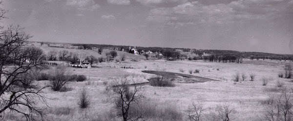
This view, looking northeast from the moraine, was taken in the 1940s prior to the planting of the pine groves still present today. The posted coordinates are close to the Sterne home (left/middle) which was located near the new shelter area.
--------------------------
The topography of Sterne's Woods is the result of glaciers traveling through this area approximately 10,000-22,000 years ago. The southern half of the park is located on top of the Cary Moraine which extends from Hebron, IL to Cary, IL, a distance of about 30 miles. The trail that passes along the southern edge of the marsh and fen area also runs along the base of the ridge of the moraine. There is an abrupt altitude change of about 100 feet through these two areas, thus making this ridge a watershed for the wetlands you see before you.
The upper portions of the moraine are composed primarily of glacial mineral deposits and a fairly permeable soil known as Kidder loam. This type of soil allows rainwater and snowmelt to travel downward through the morraine until it encounters a less permeable layer of silt and clay. The water then flows outward from the moraine and in some cases, returns to the surface. Saturated areas of land where groundwater has returned to the surface are known as seeps. There are several seeps located along the northern base of the morraine. The seeps flow year-round provide most of the water in the wetland areas. This constant supply of water creates conditions that support the wetland communities in Sterne's Woods.
Generally defined, “wetlands are lands where saturation with water is the dominant factor determining the nature of soil development and the types of plant and animal communities living in the soil and on its surface” (Cowardin, December 1979). The term "wetlands" is used broadly to cover areas known as marshes, swamps, bogs and fens. These areas vary widely as many factors can influence their makeup, such as soil content, topography, climate and water chemistry. The wetlands of Sterne’s Woods are hydrologically diverse in that they contain both marsh and fen areas.
What is a marsh?
Marshes are wetlands that are constantly or frequently filled with water. All marshes receive most of their water from surface or runoff water, though some are also fed by groundwater. Because water flows slowly through marshes, sediment and nutrients contained in the water easily falls to the bottom and settles on the marsh floor. This causes marshes to be very nutrient rich and makes them one of the most productive ecosystems on earth and allows for an abundance of plant and wildlife. The marsh at Sterne's Woods exists on an expanse of soil known as Lena Muck. This type of soil has a high organic content resulting from decaying vegetation and also has a high water-holding capacity. This trait makes the soil sensitive to changes in the level of the water table. The dominant vegetation present in the marsh is comprised of cattail, giant reed grass and sedges. However, the marsh also intergrades into the fen and sedge meadow areas of the park.
What is a fen?
Fens are peat-forming wetlands that receive nutrients from sources other than rain, usually drainage from upslope sources or ground water that has passed through the mineral deposits, such as those left by melted glaciers. They are generally less acidic than bogs and like marshes, can support a diverse plant and animal community. The fen at Sterne's Woods exists on Lena Muck soil similar to the marsh areas, but also has a shallow pond. The dominant vegetation present in the fen is comprised of low shrubs and grasses.
----------
To get credit for the cache, please email me the answers to the following questions. Do not post them in your log.
1) At the second waypoint, there are three items on the trail. What are they?
2) Proceed south down the trail that divides the fen and the marsh until you get to the T intersection. Report the distance to the posted coordinates.
3) At one point during your short walk, water can be seen flowing from one area to the other. Is the water flowing from the fen into the marsh or from the marsh into the fen?
4) (optional) Please submit a picture of your group in front of the marsh or fen. Photographer's choice!
-----Sources-----
http://www.epa.gov/wetlands/
http://dnr.state.il.us
Sterne's Woods Development Plan
-----------------
Sterne's Woods was added to the list of Illinois Nature Preserves in 1994. The 190 acre preserve contains 46 acres of wetland. Sterne's Woods is maintained by the Crystal Lake Park District.
Additional Hints
(No hints available.)