Roque de Agando
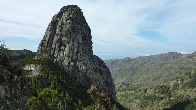
Pict. 1

English version
A series of dominating formations of rocks, the Roques, are elevating up to several hundred metres over of the surface of the landscape surrounding them. They are old volcanic vents which were filled with pasty lava with a higher acid content then basalt. The cooled down lava was harder than the coating surface material. Over millions of years the subsequent erosion made, that the surrounding and easier to erode material of rock, disappear, leaving the harder filling of the old chimney. This is what you can see here, Pict. 1, as an example by the Roque de Agando.

Pict 2.
Conditions for logging:
1. Send me an e-mail. It must contain the German word "Loganfrage" as heading.
2. Describe with your words the origin of the Roque, according to the informationboard and the text and the pictures (Pict.2) in the Listing.
3. Make a photo at the coordinates N 28°06.535 W 17°12.860, from you with your GPS and the Roque de Agando in the background. This is optional!
4. Make your log entry in the internet with the photo of you without waiting for my log permission. Log entries without a separate e-mail with your answers to the questions will be deleted after two weeks.

Versión española.
Sobre la superficie de la isla destacar una serie de pitones o Roques que pueden llegar a elevarse varios cientos de metros sobre la suelo que los rodea. Corresponden a antiguos conductos volcánicos que fueron rellenados por lavas pastosa de composición más ácida que los basaltos. La posterior acción de la erosión durante milliones de anos desmanteló las rocas circundantes, más erosionables, dejando en resalte el relleno de la antigua chimenea Pict.1.
Condiciones al gene de borda.
1. Mándame un E-Mail. Este tiene que contener la palabra "Loganfrage" (en alemán) como título.
2. Un tablero esté instalado, el origen de Roque con palabras describe según las imágenes en Pict.2.
3. Sace una foto en las coordenadas N 28°06.535 W 17°12.860, de Ti mismo con Tu GPS y con el Roque de Agando en segundo plano. Esto es volontario!
4. Escribe tu inscripción de borda en internet con la foto Tuyo sin esperar mi aprobación por Tu E-Mail con la respuesta de las preguntas. Inscripciones de borda sin E-Mail con la respuesta de las preguntas son apagadas dos semanas después.

Deutsche Version.
Eine Reihe auffallender Felsformationen, die Roques, ragen bis zu einigen hundert Meter über die sie umgebende Landschaft heraus. Es sind frühere Vulkanschlote, die mit geschmolzener Lava, mit einem höheren Säuregehalt als Basalt, gefüllt waren. Die abgekühlte Lava war härter als das umhüllende Oberflächenmaterial. Im Laufe von einigen Jahrmillionen wurde durch stetige Erosion das weichere Oberflächenmaterial abgetragen und verschwand. Zurück blieb die harte Füllung der Kamine Pict. 1, so wie man sie jetzt am Beispiel des Roque de Agando sehen kann.
Logbedingungen.
1. Schicke mir eine E-Mail. Sie muss als Überschrift das Wort „Loganfrage“ enthalten.
2. Beschreibe an Hand von Text und Bilder (Pict.2) im Listing bzw. der Informationstafel vor Ort die Entstehung eines Roque mit eigenen Worten.
3. Mache ein Foto an den Koordinaten N 28°06.535 W 17°12.860, von Dir mit dem GPS und dem Roque de Agando im Hintergrund.(Das ist freiwillig!)
4. Schreibe Deinen Logeintrag im Internet zusammen mit dem Foto von Dir, ohne meine Logfreigabe auf deine E-Mail mit der Beantwortung der Fragen abzuwarten. Logeinträge ohne separate E-Mail mit der Beantwortung meiner Fragen werden nach zwei Wochen nachträglich gelöscht.
Waldi40 earned GSA's highest level: