Start at the main parking lot at PEEC found at N 41° 10.269 W 074° 54.875. If you like, visit the extensive Visitors Center, and then proceed to N 41° 10.275 W 074° 54.753, the start of the trail.
|
To complete this earthcache, enjoy a short hike that takes you to interesting features located along the trails of the Pocono Environmental Education Center. Visit the waypoints along the trail and answer the questions below. In order to post a find on this Earthcache, submit your answers to the following questions directly to me through the Geocaching Messenger.
- Proceed to waypoint GS (N 41° 10.200 W 074° 54.747) and look for the glacial striations found here. Based on what you observe here, estimate the compass direction of movement for the glacier.
- Proceed on to waypoint FO (N 41° 10.099 W 074° 54.727). Identify at least two different types of fossils that are found in these rocks. Based on the types you found, guess what kind of environment this was a long time ago. To identify fossils here you can click on this link, Common Fossils of Pennsylvania, with sketches which may help.
- Proceed on the trail to the posted coordinates for this Earthcache. Study the bedrock outcrop exposed to the left of the trail. Guess what geologic processes helped to shape the outcrop to what you see today.
- Post a photo of yourself and/or your GPSr at this site with the vernal pool behind you. (Depending on season, there may not be water in it).
|
Pocono Environmental Education Center (PEEC), which covers approximately 38 acres of public land, is located within the boundaries of the Delaware Water Gap National Recreation Area. It is in Pike County, Northeast Pennsylvania, approximately a two-hour drive from the major metropolitan areas in NY, NJ and PA.
PEEC includes a variety of hiking trails, such as the two-mile Scenic Gorge Trail, the three-mile Tumbling Waters Trail that leads to a pair of cascades, and the one-and-a-half-mile Fossil Trail in which you can see fossils of animals that once existed in an ancient ocean.
More about hiking at PEEC
Those traveling with pets, please check this link for the Delaware Water Gap National Recreation Area's current pet policy.
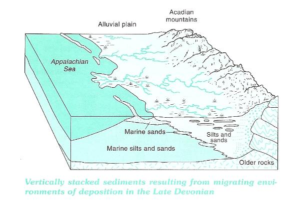
PEEC is within the Glaciated Low Plateau Section of the Appalachian Plateaus Physiographic Province. The bedrock exposed at PEEC is Devonian in age, 365-405 million years old, and is made up of sedimentary rocks such as red and gray sandstone, siltstone, and gray shale.

These rocks represent sediment that was originally deposited by streams in or near an ancient sea. The mountains that provided these sediments, the Acadian Mountains, formed by intense pressure from an earlier collision between the North American and African continental plates, and were located southeast of this ancient sea. Sediments, eroded from these mountains over millions of years, was carried by streams, and deposited, both on the sea bottom as well as along its shoreline. This environment would be similar to the present Mississippi Delta and the Gulf of Mexico. The bedrock at PEEC, part of what is known as the Catskill Formation, represents the sediments that were deposited within that sea and delta.
Jump ahead a few hundred million years to more recent times, about 21,000 years ago. A large sheet of ice, called a glacier, advanced from the north-northeast and moved slowly to the south-southwest covering NE Pennsylvania. Lower elevations may have been covered by ice 1,000 - 3,000 feet thick whereas the higher elevations would have had less. A lot can happen beneath several thousand feet of ice. As a glacier moves across the land, loose sand and rocks of different sizes are frozen in the bottom of the glacier. As the glacier advances, sometimes only a few inches per day, these materials scrape, polish and scratch the rocks beneath to form what are called striations. These well-defined marks run parallel to the direction of glacial movement. Between 18,000 and 15,000 years ago the glaciers melted and retreated back towards the north. As the glaciers melted, the rock and debris contained within the ice settled to the ground to form an unsorted deposit of boulders, gravel, sand, silt and clay. This kind of glacial deposit is called till and it can be found in several locations throughout PEEC.
This earthcache is part of the Seven Wonders of Pike County, a project developed by a team of teachers with the support of the Pike County Conservation District, dedicated to the preservation and appreciation of the great natural and historical sites in Pike County, PA, through education and recreation. There is a limited-time prize available to those who complete all of the Seven Wonders, described on the project's web page.