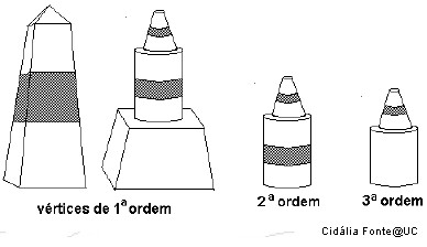
A Rede Geodésica Nacional (RGN) é composta por um conjunto de
pontos coordenados - Vértices Geodésicos - que possibilitam a
referenciação espacial.
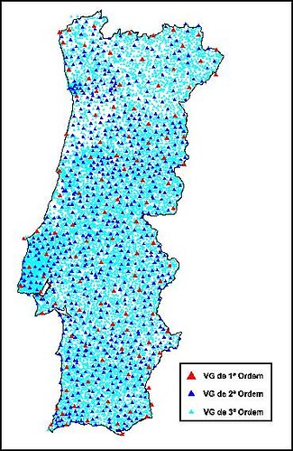
O número de vértices existentes na totalidade do território
(Portugal Continental e Regiões Autónomas) é, actualmente, de cerca
de nove mil, repartidos por vértices de:
Continente: 1ª Ordem (cerca de 120), 2ª Ordem (cerca de 900) e 3ª
Ordem (com uma densidade aproximada de 1 vértice por cada 10 km²)
Arquipélago dos Açores: cerca de 500 Arquipélago da Madeira: cerca
de 150
A RGN é a infra-estrutura básica onde se apoia toda a cartografia
do País, e que serve todos aqueles (empresas, autarquias e outros
organismos públicos e privados) que, por força das suas
actividades, necessitam de referenciar geograficamente os seus
projectos (os Planos Directores Municipais, por exemplo).
Textos retirados de :
http://www.igeo.pt/IGEO/portugues/Frameset-produtos.html
Vista do VG - De um lado pode-se observar a ponte Vasco da gama, o
Cristo Rei, etc. Do outro a vista é todo o Vale de Loures e as
Serras circundantes!
A Cache é de tamanho médio e está recheada de brindes que fui
recolhendo ao longo das minhas "cachadas". Não se admirem se
encontrarem algo conhecido. :)
Ao contrário do que estava previsto, a cache teve de ser do tipo
"Multicache".
Sendo assim,
No Ponto 1 vão encontrar uma data:
_ _ _ _ que correspondem a A B C D
O Ponto 2, e final, está em:
N38º CB.C(D-A)6
W009º A2.ABC
ENGLISH:
The National Geodetic Network (RGN) is composed by a set of
coordinate points - Geodesic Vertex - which allow for spatial
referencing.
The number of vertices exist in the whole country (Portugal
mainland and islands) is now about nine thousand, broken down by
vertices:
Continent: 1st Order (about 120), 2nd order (about 900) and 3rd
Order (with an approximate density of 1 node per 10 square km)
Azores, about 500 Madeira Islands: About 150.
The RGN is the basic infrastructure which supports all mapping
of the country, and serving all those (businesses, municipalities
and other public and private) which, by virtue of their activities,
need to reference geographically their projects (the Municipal
Master Plans, for example).
Texts taken from:
http://www.igeo.pt/IGEO/portugues/Frameset-produtos.html
Vista VG - On one side we can see the Vasco da Gama bridge, Cristo
Rei, etc.. In the other the view is about the entire valley and the
mountains surrounding Loures!
The Cache is medium size and is filled with gifts that I have been
collecting in the last months. Do not be surprised if you find
something you already known/owned. :)
Unlike what I anticipated, the cache had to be a Multicache.
Thus,
At one point they will find a date:
_ _ _ _ corresponding to A B C D
Point 2, and final, are in:
N38 ° CB.C (D-A) 6
W009 º A2.ABC