 [PL]
[PL]
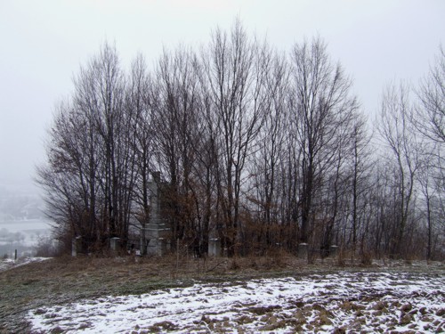
Cmentarz:
W Lowczowie, na stoku wysokiego wzgórza znajduje sie cmentarz wojskowy z I WS. Pochowanych jest tu 8 zolnierzy austro-wegierskich i 16 rosyjskich. Projektantem byl Heinrich Scholz. Pomnik stanowi duzy betonowy krzyz. Wystrój cmentarza jest skromny, jednak polozenie na skraju zagajnika nadaje mu malowniczy wyglad.
Pochowani tutaj zolnierze to glównie polegli podczas próby przelamania frontu austriackiego przez Rosjan.
Parking i dojscie:
Najlepiej pozostawic samochód na parkingu pod wspólrzednymi N 49° 54.713 E 020° 59.197. Stad do miejsca skrzyzowania przy wspólrzednych N 49° 54.724 E 020° 59.090 a nastepnie waska asfaltowa droga w dól w kierunku skrytki. Ostatni fragment przez pola. Wprawdzie mozna ta droga podjechac w poblize skrytki, jednak brak jest dogodnego miejsca do zaparkowania samochodu na bardzo waskiej drodze.
Skrytka:
Pojemnik zawiera logbook i olówek.
 [EN]
[EN]
The cemetery:
n Lowczów, on a slope of a high hill there is a war cemetery from WWI. 8 Austro-Hungarian soldiers and 16 Russian are buried there. Heinrich Scholz was the designer. There is a memorial - a high concrete cross but the decor of the cemetery is modest, however its location on the border of a grove makes it a nice place worth visiting.
The buried soldiers are mostly fallen during an attempt to break Austrian front by Russians.
The car park and access:
The best place to leave your car is at coordinates 49° 54.713 E 020° 59.197. From there go to the crossroads at coordinates N 49° 54.724 E 020° 59.090 and then follow a narrow tarmac road down to the cache. The last part of the way is through a field. You can drive very close to the cache location, but there is no handy place to park your car on the very narrow road.
The cache:
The container includes a logbook and a pencil.