 [PL]
[PL]
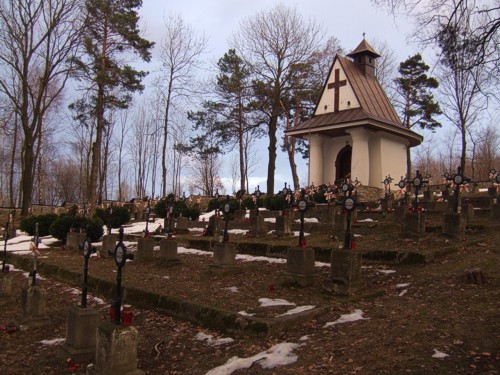
Cmentarz:
W Lowczówku, na stoku wzgórza Kopaliny znajduje
sie cmnetarz wojskowy z I WS. Pochowanych jest tu 272 zolnierzy
austro-wegierskich w tym 113 Polaków sluzacych w Legionach i 239
rosyjskich. Wiekszosc pochowanych tutaj legionistów poleglo podczas
Bitwy pod Lowczówkiem w grudniu 1914 r. W bitwie tej Legiony
poniosly najwieksze straty sposród wszystkich walk w Galicji
zachodniej w jakich braly udzial. Bylo to glównie wynikiem nie
poinformowania legionistów przez Austriaków o wycofaniu
stacjonujacych w sasiedztwie wojsk austro-wegierskich. Cmentarz
zostal zaprojektowany przez Siegfrieda Hallera i Heinricha Scholza,
jednak staraniem polskich dzialaczy udalo sie ulokowac groby
legionistów w przedniej czesci cmentarza przed kaplica ufundowana
przez Lige Kobiet.
Posród pochowanych tam legionistów znajduje sie Józef Lesiecki -
jeden z grupy pierwszych zdobywców Zamarlej Turni poludniowa sciana
w Tarach w 1910 r, która to droga uwazana byla wówczas za
najtrudniejsza w Tatrach. Znajduje sie tu takze mogila generala
Gustawa Dobka odznaczonego krzyzem Virtuti Militari, dowódcy 3
Brygady Strzelców Karpackich - zdobywców Bolonii w 1945 r.
Jest to najwiekszy w Galicji zachodniej cmentarz pod wzgledem
ilosci pochowanych tam zolnierzy Legionów Polskich. Z tego powodu
cmentarz jest zadbany, powszechnie znany w okolicy a na jego
terenie odbywaja sie rokrocznie uroczystosci i imprezy
patriotyczne.
Przy cmentarzu pod wspólrzednymi N 49° 54.412 E 020° 58.121
znajduje sie parking. W poblizu znajduje sie takze wiata
turystyczna ze stolem i lawami oraz miejsce na ognisko.
Etap 1:
Wspólrzedne prowadza do tablicy informacyjnej z
planem i przebiegiem bitwy. Znajdz na niej informacje ilu
legionistów poleglo. Pierwsza cyfre z tej liczby nazwij A,
ostania cyfre tej liczby nazwij B.
Etap 2:
Przy wspólrzednych N 49° 54.429 E 020° 58.019
znajduje sie brama cmentarza a przy niej miedziana tablica. Policz
ilosc liter w drugiej linii tekstu na tablicy i nazwij ja
CD.
Etap 3:
Udaj sie nastepnie na teren cmentarza pod
wspólrzedne N 49° 54.411 E 020° 58.034 gdzie znajduje sie kamien z
zelazna tablica. Ponizej dat na samej górze znajduje sie 2-cyfrowa
liczba. Ostatnia cyfre tej liczby nazwij E.
Etap 4:
Na koniec udaj sie pod wspólrzedne N 49° 54.409
E 020° 58.014 gdzie znajduje sie grób a na nim dwie czarne tablice.
Ostatnia cyfre z dolnej tablicy nazwij F.
Skrytka finalowa:
Skrytka znajduje sie przy wspólrzednych:
N 49° 54.FAB E 020° 58.EDC
Pojemnik zawiera logbook, olówek i kilka przedmiotów na
wymiane.
 [EN]
[EN]
The Cemetery:
In Lowczówek, on a slope of Kopaliny hill there
is a war cemetery from WWI. 272 Austro-Hungarian soldiers including
115 Poles from Polish Legions and 239 Russian are buried there. The
legionaries buried there died mostly during the Battle of Lowczówek
in December 1914. In this battle Polish Legions suffered the
biggest loss among all the battles in western Galicia in which they
took part. It was mainly due to the lack of information from
Austrians about the retreat of Austro-Hungarian army which was
based nearby. The cemetery was designed by Siegfried Haller and
Heinrich Scholz, but Polish activists made efforts to locate the
graves of the legionaries in the front of the cemetery, close to
the chapel established by Women League.
Among the buried legionaries there is Józef Lesiecki - an alpinist
and a member of the group of the 1st conquerors of southern wall of
Zamarla Turnia in the Tatra Mts. in 1910. This alpine route was
considered the hardest in the Tatra Mts. in his times. There is
also a grave of general Gustaw Dobek who was decorated with the
Order Virtuti Militari, commander of the 3rd Carpathian Riflemen
Brigade - who were the conquerors of Bologna in 1945.
It is the biggest cemetery in the western Galicia with the highest
number of buried the Polish legionaries. For that reason the
cemetery is well-kept, well-known in its neighbourhood and on its
ground there are patriotic celebrations and events organized every
year.
Close to the cemetery at coordinates N 49° 54.412 E 020° 58.121
there is a car park. There is a shelter nearby with a table and
benches and a place for camp-fire.
Stage 1:
The listed coordinates lead to an information
sign with a map and description of the battle. There you will find
out how many legionaries have fallen in the battle. Take the 1st
digit of this number and call it A, call the last digit of
this number B.
Stage 2:
At coordinates N 49° 54.429 E 020° 58.019 there
is a gate to the cemetery and a copper plaque nearby. Count the
number of letters in 2nd line of text on the plaque and call it
CD.
Stage 3:
Now go to the grounds of the cemetery at
coordinates N 49° 54.411 E 020° 58.034 where there is a boulder
with an iron plaque. Below dates on the top there is a 2-digit
number. Call the last digit of this number E.
Stage 4:
In the end go to coordinates N 49° 54.409 E 020°
58.014 where there is a grave and two black plaques. Call the last
digit on the bottom plaque F.
The final cache:
The cache is hidden at coordinates:
N 49° 54.FAB E 020° 58.EDC
The container includes a logbook, pencil and items for trade.