O'Donnell's Treasure Traditional Geocache
-
Difficulty:
-

-
Terrain:
-

Size:  (regular)
Please note Use of geocaching.com services is subject to the terms and conditions
in our disclaimer.
This is a 3 hour hike in the Bluestack Mountain range outside of Donegal Town. The terrain is boggy, and can be considered a moderately strenuous walk. It should not be attempted without appropriate hiking gear; boots, waterproof trousers, and plenty of water. Don't forget to obey the mountain code, leave no litter, lock gates behind you, etc.
O'Donnells Treasure
Local legend has it that Red Hugh O'Donnell's treasure is buried on the shore of Lough Belshade. A demon black cat will lead a red-head to it. Ever since I was a child I was on RED ALERT on that mountain, and no sign of the darn cat. So red-headed Murney hid a treasure with Si-fi for you to find.
P.W. Joyce in his "Irish Names of Places" (published 1913) gives a different, and more elaborate version of the tale I listened to many times on the beach at Lough Belshade:
Very curiously there is a lake of this name, now Lough Belshade, at the eastern base of the Croaghgorm or Bluestack mountains, about six miles north east of the town of Donegal. Here the people have a legend in connection with the name. At the bottom of the lake is a castle, in which is a casket of jewels of priceless value, guarded by an enormous demon cat: and in the dungeons of the castle many persons have been for ages held captive by the spells of an enchanter. But at some future time a descendant of the Mac Swynes of Doe Castle is to come to the edge of the lake, bringing a black pig, which he will kill and roast on a rock. The hungry demon cat, allured from his post by the savoury smell of the roasting pork, abandons his post and comes forth from the lake; and while he is devouring the pig, Mac Swyne suddenly falls on him and slays him. This breaks the spell: the lake dries up. the castle stands forth as it stood ages ago, and the captives are all set free.
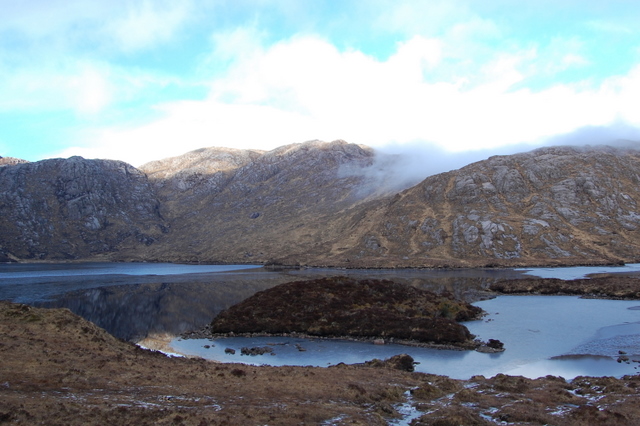
Whatever the true origin of the treasure, the best thing about Lough Belshade is the feeling of solitude you have, standing on the small peninsula at the edge of the lake looking up at the peek of Croaghgorm. It is truly the most peaceful place I have ever been. There is not one man made thing in sight, and the silence is absolute.
Getting there
From Donegal Town take the N56 towards Killybegs. Around 400metres from The Diamond take a right, and follow the signs for Harvey's Point Hotel. Continue past the turn-off for the hotel, and take a left at Edergole. Park at the co-ordinates below, taking care not to block any gates.
The walk
From the parking place, follow the trail as far as the Eas Doonan Waterfall (EDWFALL). The waterfall is stunning, but unfortunately can only be conveniently viewed from above. Don't forget to take a peek! Continue to follow the Corabber River. When the river forks at (LTLEFT) follow the left tributary to Lough Belshade. p.s. The Buttress behind the lake makes for some fantastic rock-climbing: http://www.pete-smith.co.uk/dynamic/guidebook/route_list.php?crag_no=45
Alternate Route
There has been some difficulty with access to this route, and a local farmer has put up a sign discouraging walkers. I am told this is being resolved, but in the meantime here is an alternative:
Just over 2km past the turn off for Harvey's Point, turn left at the sign for the "Bluestack Way." Continue up this rocky road for around 1km, and park at the lay by (ALTPAR). From here, follow the rocky road for one mile, through the forest, and turn right at the second bog road (ALTBOG). Follow the bog road until it peters out. From here it is a straight shot to the lake. Aim first towards the crevice between two heights in front of you. From there you will descend, and climb again, keeping the summit to your left. You will be amazed when Lough Belshade eventually looms large in the valley before you. Unfortunately, from here to the cache is some of the toughest part of the hike. I took a direct route and ended in a scramble. Instead I recommend descending to the lake shore for lunch, and reaching the cache that way.
The alternative route is similar in difficulty, but slightly longer. Allow yourself a minimum of 3.5 hours. If you're feeling particularly adventurous, you could ascend by the alternative route and return via the original route!
The cache
The cache is on a little height on the southern side of the lake. It is a moderate sized lunch box with a log-book, pencil, and a few modest trade items. It should be fairly easy to find from the co-ordinates given. It is hidden in a saucepan left by a careless camper.
Additional Hints
(Decrypt)
Haqre n ovt ebpx