Cedarburg Bog #2 - Building Up the Bog EarthCache
Cedarburg Bog #2 - Building Up the Bog
-
Difficulty:
-

-
Terrain:
-

Size:  (not chosen)
Related Web Page
Please note Use of geocaching.com services is subject to the terms and conditions
in our disclaimer.
An EarthCache adventure is treasure hunting for the caches that the
Earth has stored. EarthCache sites do not use stored containers;
their treasure is the lessons people learn about our planet when
they visit the site. Visitors to EarthCache sites can see how our
planet has been shaped by geological processes, how we manage the
resources and how scientists gather evidence to learn about the
Earth.
Cedarburg Bog is just another example of a typical bog…
Wrong! Despite being called a bog, Cedarburg Bog actually
highlights a number of successional stages of wetland development
from open water to emergent aquatics, sedge meadow, shrub carr and
eventually swamp forest. Additionally, it is an atypical example of
a “string bog”.
“Cedarburg Bog #1 – Laying the Foundation”
discussed the initial formation of the bog by glacial action and
how, over thousands of years, it filled with sediment to within 8
or 9 feet of the current surface of the bog. But what covers those
last few remaining feet?
As the lake basin filled in, the patterns of water movement and
chemistry became more complex than they had been in the open water.
Eventually the lake became shallow enough to support emergent
aquatic plants, whose remains we see today as a layer of organic
peat deposited over the lake sediments.
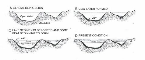
Peat is composed of the partially decayed remains of dead
plants. Peat accumulates in wet areas where the rate of production
of organic material exceeds the rate of decomposition by
microorganisms. As peat accumulates, vegetation changes from
floating to emergent aquatics and then to sedge meadow, shrub carr
and eventually to forest. All of these successional stages from
open water to swamp forest are still present in the Cedarburg Bog
and contribute to its great habitat diversity. In the forested
areas around the Bog perimeter, enough peat has accumulated to
provide almost firm ground. This Bog happens to be the largest peat
land in Southern Wisconsin.
Some of the terms related to the various regions found in the
Cedarburg Bog include:
A bog is a wetland type that accumulates acidic peat, a
deposit of dead plant material. From a hydrologic perspective, true
bogs depend only on rain as their source of water. However, the
Cedarburg Bog actually does have some spring water flowing through
it. From this view, the Cedarburg Bog is a fen, a wetland
with major groundwater inflow influencing its water
chemistry.
A string bog is a bog consisting of slightly elevated ridges
and islands, with woody plants, alternating with flat, wet sedge
mat areas. String bogs occur on slightly sloping surfaces, with the
ridges at right angles to the direction of water flow. Though
several mechanisms have been suggested as contributing to string
formation, no totally convincing explanation is yet available. The
particular string bog is 200 miles south of the next nearest string
bog which are normally restricted to the far north.
Marshes are dominated by herbaceous aquatic plants growing
in shallow water that is seasonal to permanent. Emergent aquatic
plants of shallow marshes include cattails, bulrushes, lake
sedges, arrowheads and bur-reeds. Marshes can be small to very
large, and are found throughout Wisconsin, commonly along lake and
river shorelines.
Sedge meadows are open communities with very dense
herbaceous plant growth and little bare soil. The plants, including
perennial wildflowers, grasses and sedges, grow on saturated soils;
standing water is usually only present during floods and snowmelt.
Sedge meadows often form a transition zone between open water
habitats and uplands. Organic peat/muck soils are commonly present
due to slow decomposition in these saturated soils.
Shrub carrs are swamps dominated by deciduous shrubs and are
common throughout Wisconsin. This plant community can grow on
saturated to seasonally flooded soils that are either organic
(peat/muck) or alluvial floodplain soils.
There are several types of swamp forests. Lowland hardwood
swamps are dominated by deciduous hardwood trees. Soils are
saturated during much of the growing season and may be covered by
standing water. Coniferous swamps are forested wetlands
dominated by lowland conifers. Soils are saturated during much of
the growing season and may be temporarily inundated by as much as a
foot of standing water. Soils are usually organic (peat/muck), but
no continuous sphagnum moss mat is present.
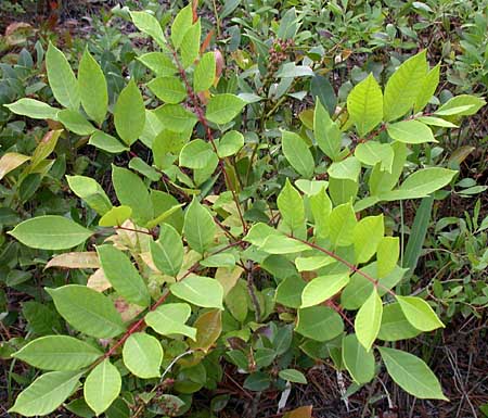
This is a DNR State Natural Area. Please stay on the trail. NO
rock climbing and NO collecting of plants (including fruits, nuts,
or edible plant parts), animals, fungi, rocks, minerals, fossils,
archaeological artifacts, soil, downed wood, or any other natural
material, alive or dead. WATCH OUT FOR THE POISON
SUMAC (see image below).
To get credit for this EarthCache, you must email me the answers
to the following 3 questions (Do NOT post them in your “Found
It” log):
(1) From the parking lot, follow the public trail first west
then south until you come to the “fork in the road”.
Looking at the vegetation around you and using the terminology
presented in the descriptions above, how would you classify this
portion of the Bog?
(2) From the Fork, follow the left trail down to the Dock.
Again, looking at the growing vegetation as your guide, how would
you classify the narrow band of wetland surrounding the perimeter
of Watt’s Lake?
(3) Return to the Fork and then head south down the right
path. No specific GPS coordinates are provided. Go only as far as
you feel comfortable given that the area may become very wet and
muddy at times. You are looking for a distinct change in your
surroundings. It will be a more open area, just west of
Watt’s Lake. Once again, looking at the vegetation, how would
you classify this portion of the Bog?
(4) Scenic pictures with your “Found It” log are
appreciated, but not required.
DISCLAIMER: I am not an Earthcache expert, but I do enjoy
finding and creating Earthcaches. The information I present is not
my own. For this Earthcache, the majority of the information came
from A Guide to the Natural History of the Cedarburg Bog by
James Reinartz of the UWM Field Station (
http://www4.uwm.edu/fieldstation/ ). It was supplemented by
information found on other Internet resources.
Additional Hints
(No hints available.)