PONTA DE SAO LOURENCO (MADEIRA) EarthCache
PONTA DE SAO LOURENCO (MADEIRA)
-
Difficulty:
-

-
Terrain:
-

Size:  (other)
Please note Use of geocaching.com services is subject to the terms and conditions
in our disclaimer.
Ponta de Sao Lourenco
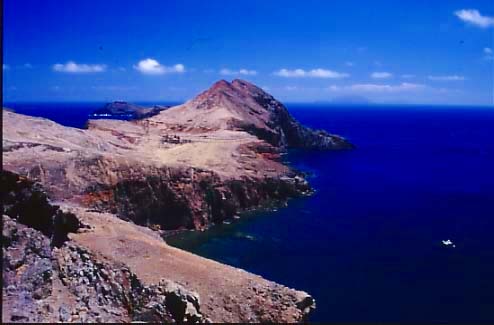
This earthcache guides you to the eastern tip of the island. Especially to a viewpoint called "Pedra furada" (in German „Seepferdchenfelsen“). Along the way there are sweeping Atlantic panoramas, colourful cliffs, bracing sea air and swooping sea birds.
Just drive your car as far east as you can go at the route 109. At the end of the road, there's a circle with a parking area. The walk begins and ends there.
Description of your way
From the parking area take the track leading directly ahead. When the track forks directly after the wooden barrier, take the right fork and head down wooden steps to the north. The wooden protective walkway curves rightwards and climbs back up again with more steps. Follow the path straight ahead until it reaches a crossroads.
Here, the left-hand path leads a short distance to a marvellous lookout point over the sea to the North (Pedra furada, task 1, headkoors), and the right-hand path leads down to a small beach (not part of the cache, but if you have your bathing suit with you…)
Your route (after fulfilling task 1) continues straight ahead eastwards, climbing to a narrow ridgetop stretch with some steep drops on both sides of the path ("estreito", waypoint 1, task 2a)).
To let this earthcache be family-friendly the tasks for this earthcache are ending at this point. If you want to, you can go further behind the Casa da Sardinha to the end of the island (use the given waypoints for orientation).

Geology
Madeira is formed by a set of multiple and varied growing volcanoes. This configuration corresponds to the relief originated in the bottom of the ocean in which the Madeira Island and the Desertas are merely but culminating parts that exceed the sea level.
The volcanic structure shape, the climate and the nature have played important roles in the relief's modelling, as it is known today. In spite of its contrasting relief and its deeply incised valleys, the present aspect of the island, viewed from a certain distance, is the one of a flattened shield dissected by the vertical erosion, of which the edges might have been broken through the billow's erosion.
The Ponta de São Lourenço represents the eastern tip of the Massif Central and corresponds to a narrow, irregular and curved peninsula, which the marine erosion is destroying intensively. It distinguishes itself from the rest of the island due to its smooth and low altitude, which is responsible for the scarce vegetation, contrarily to the remaining zones of the island.
If the sea level would lower 100 m, the Ponta de São Lourenço would extend significantly, towards the Desertas, and would be only 4,5 km away from the Ilhéu Chão. This fact shows that these islands, apparently separated from Madeira, are actually part of the same volcanic structure, of which the Madeira Island is the most important immersed part.
In prolongation of the peninsula Ponta de Sao Lourenco there are two islets (called Ilheu de Agostinho and São Lourenço (or Ilheu do Farol)), located in the easternmost zone.
Your tasks:
1.) Take a picture of you at the viewpoint (headkoors) and upload it with your log (this task is re-allowed by GC since June 2019).
2.) E-mail me the awnser to the next two tasks:
a) Meassure with your GPSr the altitude of the ridge (waypoint one, not at the Seepferdchen-viewpoint).
b) Explain (in one sentence) the genesis of the two islets Agostinho and Sao Lourenco after the volcanic period ended and the island Madeira was born (keyword will suffice).
Logs without the required e-mail will be deleted! Due to "administration" of the log-permissions it is nessecary that every team send an e-mail by itsself even if you were there together. Do not wait for log-permission, just log your found directly after sending the mail; we will contact you if there is something wrong.
Quelle:
http://www.madeiranature.com/index/cms/page/-/page/nature_geography_geology/lang/en/articleId/373/articleTitle/morphology (for the description of geology)
http://activityworkshop.net/hiking/madeira/pontasaolourenco.html (for the description of the path)

Additional Hints
(No hints available.)