Trent Aegir - A natural phenomena
 Tide waves (bores) like the Trent Aegir, one of the nation's most interesting and unusual natural phenomena, naturally occur on rivers with large tidal ranges. There are only two rivers in England that have a tidal wave. The 'bore' on the River Severn is well-known, the Trent's 'Aegir' is less well-known, yet the tidal wave can travel as far as 50 miles upstream from Hull to Gainsborough. This natural phenomenon occurs in the lower reaches of a only a few rivers throughout the world during very high tides. This photo above was taken at West Stockwith and shows the Aegir diminishing having travelled almost 40 miles, and below a photo near Gainsborough sees the Aegir wave even smaller as its another 10 miles upstream.
 A bore is formed when the tide rises in a converging channel with a rising riverbed formed in a funnel shape. The name ‘bore’ as applied to the tidal phenomenon appears to be derived from the Scandinavian or Icelandic ‘bara’ meaning wave, swell or billow. The Trent Aegir, is named after the god of the seashore or ocean in Norse mythology and, like the Scandinavian sailors in the myths, river people would fear the Aegir as it is very unpredictable and would sometimes surface to destroy ships. Sometimes the tide merely changes the flow of the river but, at its best, the wave breaks with fury as it passes by and causes damage to boats on the moorings or in its wake. It is said that when King Canute tried to hold back the tide at Gainsborough. He was recorded in history, due to his failure, and most likely, he was trying to hold back the Aegir.
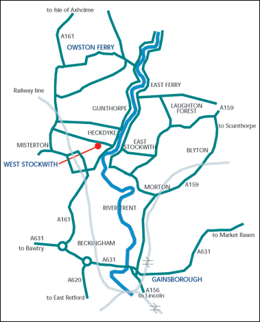 Photo, shows route of the Trent Aegir flow
At certain times of the year, the lower tidal reaches of the Trent experience a moderately large tidal bore (up to five feet (1.5m) high). The Aegir occurs when a high spring tide meets the downstream flow of the river. The funnel shape of the river mouth exaggerates this effect, causing a large wave to travel upstream as far as Gainsborough, Lincolnshire, and sometimes beyond. The Aegir cannot travel much beyond Gainsborough as the shape of the river reduces the Aegir to little more than a ripple, and weirs north of Newark-on-Trent, Nottinghamshire stop its path completely. The Trent Aegir can without notice appear up to 30 minutes before or after the stated time on the above link. Don't be late!
This earth cache may be claimed from any of the recommended positions along the River Trent. Please see the Waypoints attached for the following locations, Owston Ferry, East & West Stockwith, Morton and Gainsborough. These waypoints have additional info for parking & access.
To log this Earth Cache, you must complete, the following 4 requirements. Failure to do so, will sadly result in the deletion of your claim. Claimants will be allowed one clear day to upload photos only. If your unable to do so, maybe due to being on holiday, then please claim the cache when you get home by posting your claim on the correct date, and just inform me it's a post dated claim and why.
1)Take at least one photograph with the Aegir passing by your location (it would be nice if you could be in the photo and this could also help you in calculating the wave height) or take a photograph of the opposite bank, followed by a second photo of the same position as the Aegir passes by. Compare the two photographs and estimate the height of the wave. Please post your log with your photograph's but email me with your height estimate.
I would suggest you get a helper to take the pictures, as the wave, will pass you very quickly, however this is optional.
To estimated height of the Aegir. This should be quite easy to do. First examine both the bank sides for a focal point. A branch, or a tuft of grass for example. When the Aegir passes by, you should be able to guess the difference between the normal flow of water and the heightened Aegir level using your focal point as reference. This might be a good time to take your second photo, so you can enlarge your image at home and check your answer.
2) At what time did the Tidal Aegir pass you and what were your coordinates? Please post this info into your log.
3) Email me, what speed do you think the Aegir passed you? It maybe helpful to walk a small section prior to the event. A distance of 1/10th mile is suffice for a true calculation. Time the wave from your start mark to your end mark. Calculate the time from the distance travelled and hey presto!
4) Email me. Was the bore early, on time or late, and "in your opinion" why do you think this was so.
Please remember to release your email address for us to contact you with acknowledgement you have passed the criteria of this Earth Cache. Thank you.
THIS EARTH CACHE CAN ONLY BE CLAIMED IN DAYLIGHT HOURS.
THE AEGIR DOES NOT HAPPEN OFTEN, SO YOU WILL HAVE TO PLAN WHEN YOU WILL VISIT THIS LOCATION.
RESEARCH IS NECESSARY THATS WHY ITS A 4.5 STAR CACHE !
***This link will take you to the Environment Agency Tide Tables for Owston Ferry***
The coordinates above only for reference and parking here is recommended at the Public House over the road by the Chesterfield Canal Bridge.
It would not be possible to do the necessary calculations and observations at night time, so hence, Night time photos will not be accepted. Sorry!
Difficulty is set, due to timings required. Not only do you need to be there on a specific date, but also at least 30 minutes early as the Aegir can occur basically, when it likes. Be ready.
Water is dangerous, please take care and keep children supervised at all times. Cache owner will not accept responsibility for any injury whatsoever.

The Imp is a Platinum Earthcache Master.