Fluß aus Granit EarthCache
-
Difficulty:
-

-
Terrain:
-
Size:  (other)
Please note Use of geocaching.com services is subject to the terms and conditions
in our disclaimer.
D e r D o o s t
- F l u ß a u s G r a n i t -

 />
/>
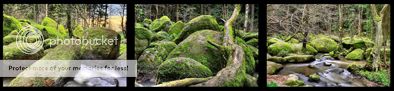
Ihr bewegt Euch im ältesten Naturschutzgebiet der Oberpfalz!
Wie von Riesenhand geschaffen, liegen auf einer Länge von rund 500 Metern
rundliche Granitfelsen über- und nebeneinander getürmt.
Der Doost ist mit seiner geologischen Geschichte ein einmaliges erdgeschichtliches Zeugnis.
Dies hat ihm schon früh, seit dem 14. Oktober 1937, den Schutzstatus eingebracht.
Unter Schutz steht auch die besondere Vegetation in diesem Gebiet. Dazu gehören unter anderem die Moose, Flechten und Farne, die die Granitblöcke besiedeln. Diese zu schützen, bedarf es daher des uneingeschränkten Einhaltens des Wegegebotes.

Granit wird stets von zahlreichen, natürlich entstandenen horizontalen und vertikalen Spalten und Rissen durchsetzt (= Klüfte). Sind diese Klüfte in der Tiefe meist noch geschlossen, vergrößern sie sich nahe der Oberfläche durch die Einwirkung von Verwitterungslösungen. Dabei werden die Kanten und Ecken der von den Klüften begrenzten Granitquader mehr und mehr gerundet - es bilden sich die bekannten rundlichen Wollsackformen des Granits. Besonders unter den feuchtwarmen Klimabedingungen des Tertiärs wurde der Granit entlang seines Kluftsystems oberflächennah regelrecht aufgelöst - übrig blieb ein oft viele 10 Meter, manchmal sogar über 100 Meter dicker Verwitterungsmantel aus Resten mehr oder weniger großer Granitblöcke. Diese schwammen meist isoliert in der Verwitterungsdecke.

Im Quartär (in den letzten rund 2 Millionen Jahren) tieften sich unsere Flüsse und Bäche in das flache Relief ein - vornehmlich in die Bereiche mit den tiefgründigen Verwitterungsdecken. Die wenig verwitterten Felsformationen im Boden werden oft freigelegt - nicht selten nur die obersten Partien.
Auch der Girnitzbach tiefte sich im Quartär ein und trug einen großen Teil des Verwitterungsmantel mit sich fort. Es entstand ein flaches Tal. Der Girnitzbach schaffte es jedoch nicht, die aus dem Verwitterungsmantel zunehmend freigespülten Granitblöcke zu transportieren. Diese bis mehrere Meter großen Blöcke konnten während der Eiszeit allerdings durch häufigen Frosthub und langsames Bodenfließen mehrere Millimeter bis wenige Zentimeter pro Jahr hangabwärts befördert werden. Sie sammelten sich im Bereich des heutigen Baches, wenngleich auch höher als heute.

Fortwährende Eintiefung und Abtransport des feinkörnigen Verwitterungsmaterials zwischen den Granitblöcken durch den Girnitzbach führte zur Anhäufung des heutigen Phänomens. Der zwischen den Blöcken vorhandene Porenraum reicht aus, das Wasser des Baches aufzunehmen. Es fließt daher durch bzw. unter den Steinen hindurch.

Tosende Wasser
Sagen und Geschichten um den Doost gibt es reichlich.
Ebenso vielfältig sind die Deutungen seines Namens. Wahrscheinlich leitet er sich jedoch von dem gleichen Wortstamm wie das Wort "tosen" ab. Besonders im Frühjahr zur Schneeschmelze ist die Bedeutung dieses Wortes sehr gut hörbar.
Doch nun zum Loggen :
1. Erstellt bitte eine Aufnahme von Euch und Eurem Emfangsgerät vor den Granitblöcken!
2. Was schuf das Wasser im Laufe der Jahrtausende ?
3. Wie nennt man den eingebrannten Fußabdruck ?
Berichte ohne Bildupload oder ohne das die Antworten an mein Account gesendet wurden, wandern ins Archiv! Es darf gleich geloggt werden - bei Problemen hört ihr ein „Hallo“ von mir...;)
Ein herzliches Dankeschön schon mal vorab das ihr diesen Earthcache besucht habt.
Ich hoffe Ihr hattet eine gute Zeit dort draußen und genießt das tolle Rauschen.


The Doost
You are walking in the oldest nature reserve of Upper Palatinate! As from gigantic hand created, on a length of about 500 metres plump granite rocks lie side by side piled up.
The Doost is a unique geological report of the geologic history. Under protection stands also the special vegetation of the block stream., Among the rest, the mosses, lichens and ferns which settle the granite blocks belong to it. Please stay on path to protect this unique landscape.
Granite always becomes from numerous, of course resulted horizontal and vertical columns and tears puts through (= gaps). If these gaps are mostly still closed in the depth, they grow near the surface by the effect of decomposition solutions. Besides, the edges and corners of the granite ashlars restricted by the gaps are rounded more and more - there form the known plump woollen bag forms of the granite. Particularly under the humid climate terms of the Tertiärs the granite was properly dissolved along his gap system near to surface - for the rest, even more than 100-metre-thick decomposition coat from rests of more or less big granite blocks remained often many 10 metres, sometimes. These swam mostly in isolation in the decomposition cover.
At the Quartär (in the last about 2 million years) rivers and brooks sink more and more in the level relief - particularly in the areas with the profound decomposition covers. The little weather-beaten rock formations in the ground are often exposed - not seldom only the uppermost parts.
Also the brook Girnitz sink itself in the Quartär one and carried away a large part of the decomposition coat with itself. There originated a level valley. Nevertheless, the brook Girnitz did not get to transport the granite blocks increasingly free-rinsed from the decomposition coat. These blocks several metres to could be carried during the ice age, however, by frequent frost heave and slow ground flowing several millimetres to few centimetres per year down. They gathered in the area of the today's brook, although also higher than today.
Perpetual deepening and evacuation of the fine-grained decomposition material between the granite blocks by the brook Girnitz led to the accumulation of the today's block stream.
The pore space available between the blocks manages on taking up the water of the brook. Hence, it flows in or under the block stream through.
Blustering waters
There are legends and stories around the Doost richly. The interpretations of his name are as varied. Nevertheless, probably he is derived from the same stem of the word like the word "roar". Particularly in the spring to the thaw the meaning of this word is very well audible.
Your tasks for log-authorisation:
1. Take a picture of you and your GPS in front of the block stream!
2. What created the water in the course of the millenniums?
3. How does one call the branded footprint?
Reports without uploading the picture or without the answers were sent to my account - i can’t accept! you may log immediately! there are some problems ? - I will say hello to you ;) ...
A hearty thank-you for visiting this Earthcache. I hope you had a good time there.
Additional Hints
(No hints available.)