
Picacho de Calera and Picacho Gemelo are the names of twin peaks
located northwest of Tucson in the Marana/Rillito area. Twin peaks
are not unique, but are rather unusual enough to be recognized by
having a nearby road named “Twin Peaks Road.” The name
“Picacho de Calera” means “peak of the limestone
mine,” and “Picacho Gemelo” means “twin
peak.” These are Spanish names that were given to the twin
peaks when the area was part of the Spanish Empire in the
1500-1600’s. Picacho de Calera was known to be a major
deposit of limestone for centuries. The figure below shows a cross
section of the two peaks.

The different types of rock appear vertical now, but originally,
many millions of years ago, were horizontal. These are
sedimentary-type rocks that were laid down over years beginning
with the Precambrian schist, with the Cambrian quartzite being
added on top. The other layers were added over time (going from
left to right in the chart), with the Pennsylvanian Naco limestone
being the last and top layer. Subsequently, during the formation of
the current landscape, the horizontal sedimentary layers were moved
to the near vertical orientation and the subsequent modern twin
peak formation. (Because the limestone was formed as sediment at
the bottom of a prehistoric lake, there are also a number of
fossils of ancient creatures contained within the sediments.)
Limestone is the main component used in making Portland cement.
Joseph Aspdin received an English patent for the process in 1824
and named the product “Portland cement” because it
resembled stone from the Isle of Portland, off the coast of
England. Today, Portland cement is a generic name and does not
refer to Portland, Maine or Oregon.
In the late 1940’s, Arizona Portland Cement established a
Portland cement manufacturing facility in Rillito and began to mine
the limestone at Picacho de Calera. There are three types of
limestone in Picacho de Calera – Martin, Escabrosa, and Naco.
Each of the limestone deposits has slightly different compositions.
None of them is pure calcium carbonate, but contain different
impurities, some which are useful in the manufacture of portland
cement and some which are not.
Over the years, Picacho de Calera has been completely mined and
is no longer there. There is now a pit in its place where the
limestone is still being removed for use in making Portland
cement.
The coordinates will take you to the western side of Picacho
Gemelo. It is still standing and will not be mined, since it
contains no minerals useful to the cement-making operation. By
looking closely at the pictures and maps below, you can estimate
the size of Picacho de Calera.
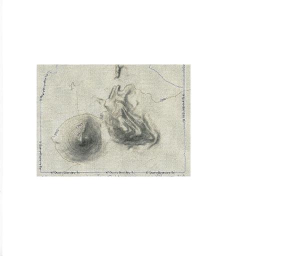
Assume that Picacho Gemelo (which you can see directly in front
of you by facing east) is a cone. Its height, from ground level
(2200) to its peak (2765) is 565 ft. The diameter of its base is
about 1700 feet. The formula for determining the volume of a cone
is:

Where V is the volume of the cone, r is the radius of the base
(one-half of the diameter) and h is the height of the cone. Using
the information provided above, calculate the approximate volume of
Picacho Gemelo in cubic feet. (You can determine the volume in
cubic yards (cy) by dividing by 27.) To give some perspective, a
small dump truck holds five cubic yards of material.
Looking at the pictures and the maps, it appears that Picacho de
Calera has a volume about twice that of Picacho Gemelo. It is a
sizeable amount of material that has been mined in fifty years to
manufacture Portland cement. (Please note that not all of the
material in Picacho de Calera has been used. You can easily see the
unusable material that has been placed around the boundary of the
quarry.)
Now, please continue to the second set of coordinates (N 32
24.737, W 111 08.891) which will take you to the entry of Arizona
Portland Cement Company. The easiest way to get there is to
continue north on Sandario Road to Twin Peaks (!) Road. Turn right,
heading east and continue until you reach the freeway frontage
road, which will take you to the second set of coordinates.
The limestone and other materials are conveyed on a overland
conveyor built in 1972, (which, when built, was the longest
conveyor of its kind in the world.) from the Picacho de Calera
quarry to the cement plant, about 3.8 miles. At the manufacturing
plant the limestone and other materials are ground into a fine
powder and mixed with other chemicals to form the cement raw mix.
Simplistically, the materials used to manufacture Portland cement
include limestone, clay, iron ore, and bauxite. The exact
composition of these raw materials is varied depending upon the
type of Portland cement desired. These raw materials are finely
ground (0.074mm or 0.0029in. particle size) and then heated in a
rotating kiln to more than 1400ºC. During the temperature
changes in the rotating kiln there are a succession of complex
chemical reactions that occur eventually resulting in small nodules
called “clinker.” The clinker is then mixed with small
amounts of raw limestone and gypsum and then ground into a fine
powder – Portland cement.
The bulk of the resulting Portland cement is then combined with
aggregate (gravel), sand, and water to form concrete, a very common
material widely used in modern construction. Most all of the
concrete used in construction in southern Arizona is made from
Portland cement manufactured at the Arizona Portland Cement
Company.
To log this earthcache, you must do the following:
1. Calculate the approximate volume of Picacho Gemelo in cubic
yards, using the information and formula provided above. Then
estimate the approximate volume of Picacho de Calera as it existed
prior to mining.
2. At the second set of coordinates, measure the size of the large
block of limestone that appears at the entrance to Arizona Portland
Cement Co.
3. What are the colors of the two large logos at appear at either
side of the entrance to the plant?
DO NOT POST the answers to these questions in the earthcache
log. Instead, please email me the answers.