We may think that before there was GPS people navigated by the
stars, using only a compass and sextant. In fact, there was a
system to allow navigation using terrestrial radio signals to
determine one's position. Unlike GPS, this ancient system was not
global. The low frequency radio signal could only travel so far,
but it has the property of propagating via groundwaves that follow
the surface of the Earth, so the signal did travel over the
horizon.
Transmission stations were placed hundreds of miles apart and
organized into chains that consisted of a master station and two or
more secondary stations. The master station would send a series of
pulses followed, in turn, by pulses sent from each secondary
station in the chain. The shape of the individual pulses as well as
the the pattern of the entire pulse sequence is shown in Figure
1.
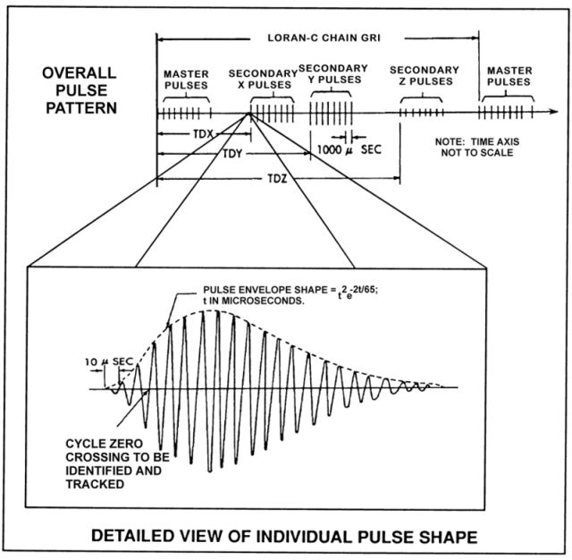
Figure 1.
The spacing between the master signal and each of the secondary
signals was governed by several parameters. The general idea was
that the signals from each station cleared the entire chain
coverage area before the next signal was transmitted, so that no
signal could be received out of order. The time required for the
master signal to travel to the secondary station is the average
baseline travel time (BTT). An additional delay referred as the
secondary coding delay (SCD), or sometimes just as coding delay
(CD), was added at each secondary station. The total of these two
delays, termed the emission delay (ED), is the exact time interval
between the transmission of the master signal and the transmission
of the secondary signal. Each secondary station has its own ED and
these were selected to guarantee that the signals arrive at the
receiver in order.
Once the last secondary station transmitted, the sequence
repeated. The rate at which this repeats was unique for each chain
and is called the group repetition interval (GRI). The chains were
usually referred to by their GRI.
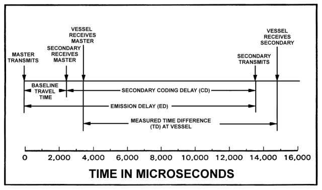
Figure 2.
Additional signals were transmitted as part of the pulse group
to help remove skywave contamination from the groundwave signal and
to indicate the suitablity of using certain secondary stations.
Once a receiver would lock on to the sequence of pulses from a
chain of stations, it would take precise measurements of the time
difference (TD) between the reception of the master station pulses
and the pulses from each of two secondary stations. The locations
that have a specific TD value between the master and a secondary
station form a line of position (LOP). These LOPs are actually
hyperbolas. (See Figure 3). With two TDs, the intersection of the
LOPs could be calculated or read off a chart.
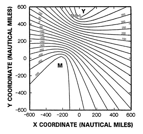
Figure 3.
The outline above assumes that the signals propagate at the
speed of light in free space. In reality the speed at which the
signal propagated was reduced by the atmosphere and the type of
conductive surface the groundwave passed over. The reduction in
propagation speed due to the atmosphere was corrected by the
primary phase factor (PF). Similarly, a secondary phase factor (SF)
accounts for the reduced propagation when the signal travel over
seawater. Because land surfaces have lower conductivity than
seawater, the signal propagation is further reduced by an
additional secondary factor (ASF). This is somewhat difficult to
calculate as there is variability as the signal passes over
different kinds of terrain.
When I hid this cache, I used a piece of ancient equipment that
gave me the following reading:
GRI 9940
TD XRAY 28221.26 microseconds
TD YANKEE 41115.29 microseconds
In addition I found this table on the Internet
| U.S. WEST COAST CHAIN - GRI 9940 |
| Station |
Latitude (N) |
Longitude (W) |
ED (μSecs) |
CD (μSecs) |
Power (kW) |
| Fallon, NV (Master) |
39° 33' 06.740" |
118° 49' 55.816" |
|
400 |
| George, WA (WHISKEY) |
47° 03' 48.096" |
119° 44' 38.976" |
13796.78 |
11000 |
1400 |
| Middletown. CA (XRAY) |
38° 46' 57.110" |
122° 29' 43.976" |
28094.60 |
27000 |
400 |
| Searchlight, NV (YANKEE) |
35° 19' 18.305" |
114° 48' 16.881" |
41967.30 |
40000 |
540 |
If you were thinking of pulling out your old equipment and using
it to find the cache, you're out of luck. Effective at 2000Z time
on February 8, 2010, the U.S. Coast Guard terminated the
transmission of all U.S. signals in accordance with the Department
of Homeland Security Appropriations Act. As of that time, the U.S.
LORAN-C signal is unusable and permanently discontinued.
While there are programs out there that allow the conversion of
TDs to latitude and longitude, I would caution against using them.
In order to make this puzzle at least somewhat solvable, I have
simplified the PF, SF, and ASF. Instead assume that the signals
propagate at the speed of 299,550,062 meters/second along the
surface of a WGS-84 ellipsoid. Depending on the method you use to
solve this, you may be off 150 feet or more. (One reason why
geocaching wasn't invented in the LORAN era.) I've included a
spoiler pic hoping that at least you'll get to the right area and
be able to spot the two bushes. Head between the bushes and look
for an ammo can in the eastern one.