Weisse Hohl bei Nussloch (Rhein-Neckar-Kreis)

Das Einsinken des Buntsandsteins von Heidelberg aus in südlicher Richtung nach Wiesloch hin wird geologisch als Beginn der Kraichgauer Senke definiert. Es ist somit auch der Anfang der größten flächenhaften Auflage von Löss in Baden-Württemberg.
Die Mächtigkeit der quartär-zeitlichen Lössablagerungen zeigt sich am deutlichsten in der Ausprägung der durch die Menschen enstandenen Hohlwege. Ein charakteristisches Beispiel ist die bekannte "Weiße Hohle" bei Nussloch, am westlichen Rand des Kraichgau. Im Kernbereich des Geotops erreichen die steilen Lößwände stellenweise eine Höhe bis zu 6 Meter. In welchem zeitgeschichtlichen Abschnitt dieser Hohlweg entstanden ist, ist unklar. Möglicherweise geht die Enstehung bis auf die Römer zurück, die bereits im 1. Jh nach Chr. hier siedelten und Bergbau betrieben
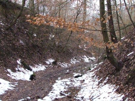
Die Weiße Hohle am Ortsrand von Nussloch (Rhein-Neckar-Kreis) stellt einen ca. 4 bis 8 m tief eingeschnittenen Lößhohlweg dar, der heute nicht mehr als direkte Ortsverbindung Nussloch - Maisbach genutzt wird. An den Lößwänden ist stellenweise der Übergang von Lößlehm zu Löß mit eingelagerten Lößkindeln (Karbonatkonkretionen) gut zu erkennen.

Der Hohlweg und die angrenzenden Waldflächen sind eingebettet in das 2005 ausgewiesene Landschaftsschutzgebiet Bergstraße-Süd (Größe ca. 2.716 ha).
Achtung ! Neue Logbedingungen:
Beantwortet folgende Fragen:
1.) Bis zu wievielen Metern dick können hier im Kraichgau die Lößdecken werden ?
2.) Wieviele verschiedene Eiszeiten bildeten dieses mit Lößpaketen reich gegliederte Profil ?
Die neuen Guidelines von Earthcache.org schreiben vor, die Beantwortung der Fragen sollen den Hauptbeweis für den Besuch der Cacher vor Ort darstellen !
Deswegen:
Links am Einstieg zur Weißen Hohle befindet sich ein weißes Schild:
3.) Wie heißt das längste Wort ?
Aus den Antworten stellt nun die Lösungsemail zusammen:
Antwort1Antwort2Antwort3@haliju.de (zB 707Landkreis@haliju.de)
Bei richtiger EMailAdresse erhaltet ihr direkt die Logfreigabe-Mail.
Bitte keine Antworten in den Log schreiben, das führt direkt zur Löschung des Logs.
Ein Foto von Euch mit eurem GPSr und/oder der Weißen Hohl im Hintergrund wäre nett.
Logs ohne Freigabe werden gelöscht !!!
{english}
Sinking the new red sandstone from Heidelberg in southern direction to Wiesloch is defined geologically as a beginning of the Kraichgauer dip. It is therefore also the beginning of the biggest surface-like edition of loess in Baden-Wurttemberg.
The thickness of the quaternary timed loess depositions appears most clearly in the stamping of the hollow ways evolved by the people. A typical example is the known "white hollow" near Nussloch, in the western edge of the Kraichgau. In the core area of the geotop the precipitous loess walls reach here and there a height up to 6 metres. In which time-historical segment this hollow way has originated, is unclear. Possibly the formation pointed up to the Romans, already in 1. Jh to Chr. here settled andpursued mining.
The white hollow in the local edge of Nussloch (rhine neckar distrikt) shows a cut from approx. 4 to 8 m deeply loess hollow way, the no more than direct local connection today Nussloch - Maisbach is used. On the loess walls the crossing of loess loam to loess with stored Lößkindeln (carbonate concrete ions) feels well here and there to recognise.
Attention: New Requirements for logging
Before logging this EarthCache you must answer the following questions:
1.) Up to how many metres the loess covers can become thick here in the Kraichgau ?
2.) How many different ice ages form this profile richly jointed with loess packages ?
The new Guidelines of Earthcache.org prescribe, the answer of the questions should show the main proof of the visit of the Cacher on site!
For this reason:
On the left in the entrance to the white hollow there is a white signboard:
3.) Search for the longest word !
Put the Answers together to an EMail-Adress:
Answer1Answer2Answer3@haliju.de (e.g. 707Landkreis@haliju.de)
If your Answer-Email is correct, you got a Clearance-EMail.
A picture with you and/or your GPS with the white hole in the background would be nice.
Do not post any answers in the log or post pictures showing the information table.
Logs without clearance will be deleted.