Begebt Euch zu den angegebenen Koordinaten. Parken könnt Ihr bei:
N 50 41.340 E 006 28.706
Der Buntsandstein ist die untere lithostratigraphische Gruppe der Germanischen Trias in der Geologie. Der Begriff Buntsandstein ist etwas verwirrend; er bezeichnet keinen bestimmten Gesteinstyp (also ein buntgefärbter Sandstein), sondern eine meist mehrere hundert Meter mächtige Gesteinseinheit, die überwiegend aus Sandsteinen aufgebaut ist. Früher wurde der Buntsandstein (und auch der Muschelkalk) zum Teil auch als Untertrias bezeichnet. Die Entstehung des Buntsandstein setzte zu unterschiedlichen Zeiten ein und kann somit nicht zur Unterteilung des Trias genutzt werden. Daher darf der Buntsandstein heute nur noch als Gesteinseinheit (= Einheit der Lithostratigraphie) aufgefasst werden.
Petrographische Beschreibung:
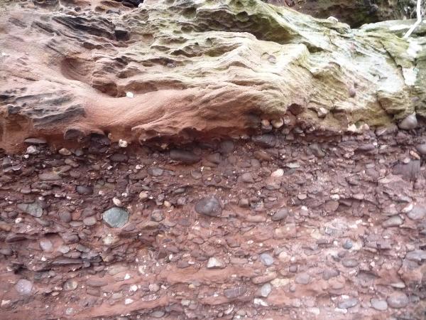
Mittelsandiger und fein- bis mittelporiger Sandstein. Schräggeschichtet, bisweilen auch kreuzgeschichtet. Konglomeratische Lagen mit Geröllgrößen bis 8 cm treten gelegentlich auf.
Mineralbestand:
Komponenten 80 %, Bindemittel 4 %, sichtbarer Porenraum 16 %.
Komponenten:
Quarz 86 %, Gesteinsbruchstücke 13 %, opakes Erz und Schwerminerale 1 %.
Bindemittel:
fast ausschließlich kieselig, geringer toniger Anteil, zum Teil eisenschüssig.
Der Buntsandstein ist im Rurtal besonders stark verfestigt, so dass hier der Sandstein über der Rur bei Nideggen bis zu 50 Meter hohe senkrechte Felsklippen, türme und -wände bildet. Durch die Verfestigung ist der Buntsandsandstein im Rurtal außerordentlich standfest und für den Klettersport in besonderer Weise geeignet. Diese Region erfordert einen eigenen Kletterstil. An den kompakten, grob strukturierten Felsen werden in der Regel die durch die Verwitterung herauspräparierten Gerölle als Griffe und Tritte genutzt. Dies erfordert besonders in höheren Schwierigkeitsgraden - eine hohe Maximalkraft und Kraftausdauer der Finger. Die notwendigen Techniken stellen eine Mischung aus Griff-, Tritt- und Reibungskletterei dar. Auch Risstechniken müssen beherrscht werden. Abgespeckte Routen gibt es kaum. Nach Regen können innerhalb kürzester Zeit alle frei stehenden Routen wieder begangen werden. In schattigen, bewaldeten Bereichen kann sich allerdings - besonders nach längeren Regenperioden - die Feuchtigkeit recht lange halten. Vergleichbare Klettergebiete existieren nur in Spanien (Montserrat) und Griechenland (Meteora). Reglementierungen Das Klettern an den Buntsandsteinfelsen des Rurtales ist gegenwärtig nur an einigen wenigen Felsen in der Form des sog. reglementierten Kletterns erlaubt.Der Sandstein war zum Teil sehr brüchig und viele der „eingebackenen“ Kiesel hielten ob der fragilen Verbindung keiner größeren Belastung stand. Mittlerweile hat sich das geändert und in den meisten Routen ist der Fels ausreichend fest. Die aus dem Sandstein hervortretenden Kiesel bilden zu 90 Prozent die erforderlichen Griffe und Tritte. Deren Vielzahl täuscht eine große Auswahl vor. In Wirklichkeit sind nur wenige brauchbar. Durch die meist runde Form und glatte Oberfläche der Kiesel muss beim Klettern sehr viel Fingerkraft eingesetzt werden. Ein großer Vorteil des Gesteins: Es wird auch bei häufiger Benutzung nicht schmierig.
Macht bitte optional ein Foto von euch ODER eurem GPS (mit sichtbaren Koordinaten) und fügt es eurem Log-Eintrag hinzu.
Außerdem schickt mir eine Mail mit folgenden Angaben :
1.) Betrachte die Wand am Aussichtspunkt. Ist sie homogen aufgebaut oder gibt es Unterschiede in ihrer Struktur ?
2.)Warum glaubst du, ist das so?
3.)Im Bereich des verschlossenen Höhleneingang ist der Buntsandstein sehr grob. Untersuche die Festigkeit.
Danach könnt Ihr sofort loggen. Wenn irgend etwas nicht in Ordnung sein sollte, melden wir uns.
Also in English:
Castle wall Nideggen
Now go to the given coordinates.
Parking at: N 50 41.340 E 006 28.706
Lithostratigraphy is a sub-discipline of stratigraphy, the geological science associated with the study of strata or rock layers. Major focuses include geochronology, comparative geology. The term new red sandstone is confusing something; it does not mean a certain type of rock (this is a multicolored-colored sandstone), but usually a several hundred meters powerful rock unit, which is composed of sandstones predominantly. In former times the new red sandstone (and also the shelly limestone) partially called as Untertrias. The origin of red sandstone began in several times and cannot be used to classify the Triassic. Therefore the new red sandstone may be only understood today as rock unit (= unit of the Lithostratigraphie).
Petrographic description:
Size of sand is in the middle and fine to centralporous sandstone. Diagonal-laminated, sometimes also cross-laminated. Konglomerati situations with rubble sizes to 8 cm arise occasionally.
Mineral constituent:
Components 80%, cement 4%, visible pore area 16%.
Components:
Quartz 86%, rock fragments 13%, opakes ore and heavy minerals 1%.
Cement:
almost pebble stone, small clay portion, partially iron mineral including.
The colored sandstone is very strongly solidified in the Rurtal, so that here the sandstone in top of the Rur near Nideggen has formed rock cliffs, towers and walls up to 50m vertically. On the basis of this solidification the colored sandstone is extraordinarily stable and for the climbing sport in special way suitably in the Rurtal. These region requires its own climbing style. Usually the compactly, rough structured rock is used by footsteps and grips that have been build by erosion. Especially in higher levels of difficulty and terrain you need a high maximum strength of grips and force perseverance of the fingers. The necessary techniques represent a mixture from seizing, stepping and climbing by friction. Also tear techniques must be controlled. At least there are less simple routes. After raining showers all freely standing routes can be used again within shortest time. Especially after longer rain periods humidity might last a longer time in shady and woody areas. There are just assimilable climbing areas in Spain (Montserrat) and Greece (Meteora). Environmental codes of conduction / Codes of behaviour: At present climbing to new red sandstone rock of the Rurtal is permitted only to some few rocks. This is the so-called officialized climbing. Partially the sandstone was very fragile and many adhered flintstones where not able to stay in an entire structure and compound even when they where under short time pressure. Meanwhile things have changed and the structure of the rocks is compact enough for climbing . 90 % of the necessary grips and footsteps are given by the naturally flintstones that show out of the sandstones. The flintstones multiplicity pretends a large selection of possibilities. In fact only few are useful. By those usually round form and smooth surface of the flints very much finger strength must be used when climbing. A huge pro of the rock: It does not become smudgy even when its frequently used.
I would be very happy for a picture of you at this location. But this is of course not mandatory. To log this cache successfully, please answer the following questions and mail the answers to us. After that you can give your log directly. If anything is not ok, we will contact you.
1.) Look at the wall on the lookout. Is it a homogeneous structure or are there differences in their structure ?
2.)Why do you think that is?
3.)In the area of the sealed cave entrance the red sandstone is very coarse. Examine the strength.
After that you can give your log directly. If anything is not ok, we will conntact you.